MyTopo
Stanwood Washington US Topo Map
Couldn't load pickup availability
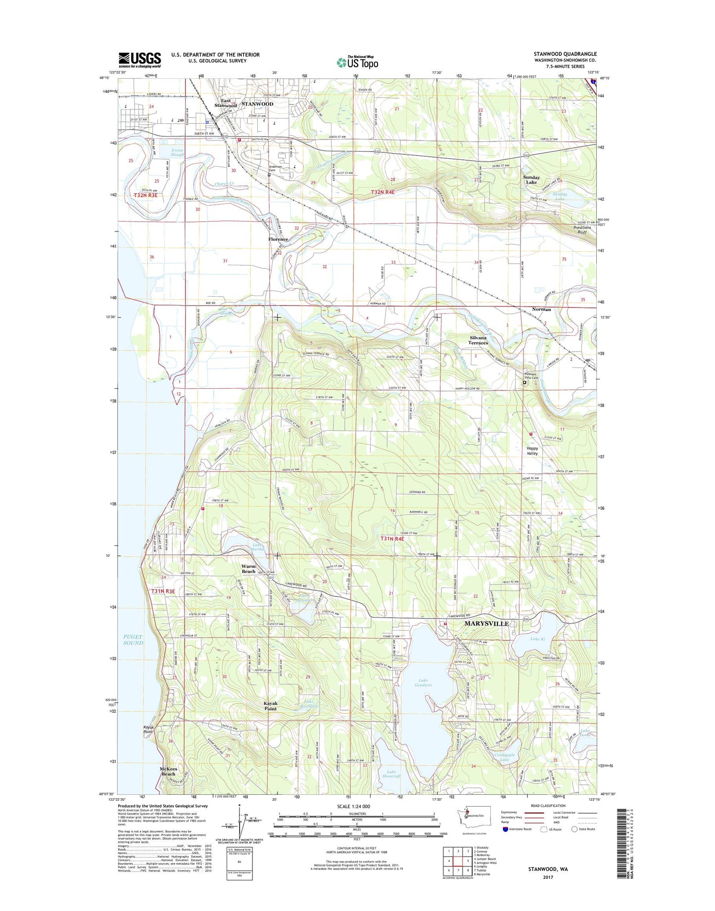
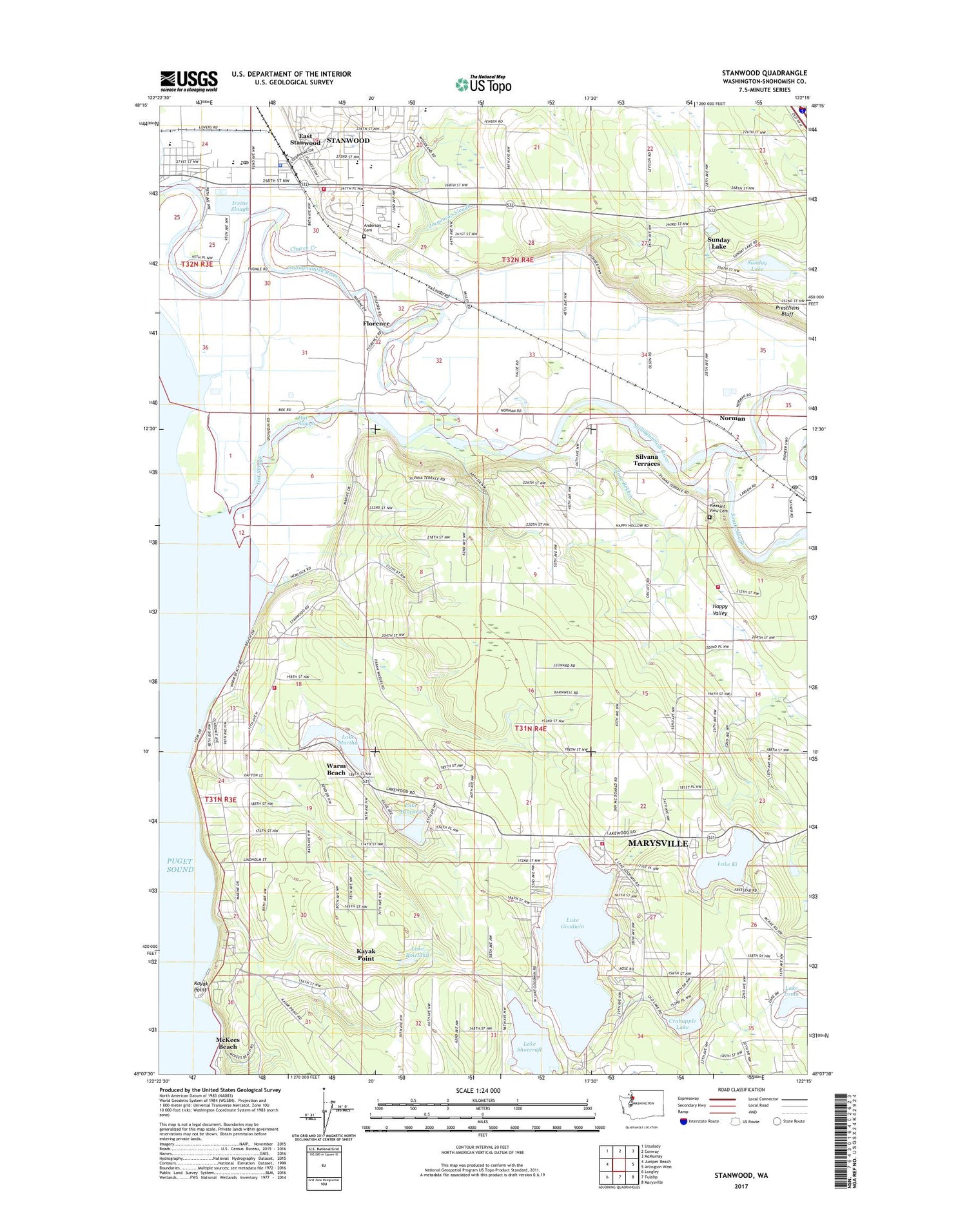
2020 topographic map quadrangle Stanwood in the state of Washington. Scale: 1:24000. Based on the newly updated USGS 7.5' US Topo map series, this map is in the following counties: Snohomish. The map contains contour data, water features, and other items you are used to seeing on USGS maps, but also has updated roads and other features. This is the next generation of topographic maps. Printed on high-quality waterproof paper with UV fade-resistant inks.
Quads adjacent to this one:
West: Juniper Beach
Northwest: Utsalady
North: Conway
Northeast: McMurray
East: Arlington West
Southeast: Marysville
South: Tulalip
Southwest: Langley
Contains the following named places: Anderson Cemetery, Camano Vu Dairy, Camp Killoqua, Cedarhome Elementary School, Church Creek, Church Creek Elementary School, City of Stanwood, Cliffhaven Jersey Farm, Country Koi Farm, Crabapple Lake, Eagle Tree Farm, East Stanwood, Ellingsen Farm, Florence, Florence Island, Free Methodist Christian Church of Warm Beach, Glade Bekken, Green Acres Daycare Center, Green Wood Grange, Happy Valley, Hat Slough, Hillside Farm, Irvine Slough, Jorgenson Slough, Josephine Sunset Home Nursing Home, Kayak Point, Kayak Point Census Designated Place, Kayak Point Golf Course, Kingdom Hall of Jehovahs Witnesses, Kwant Dairy, Lake Goodwin, Lake Goodwin Census Designated Place, Lake Goodwin Substation, Lake Howard, Lake Ki, Lake Ki Mobile Home Park, Lake Loma, Lake Martha, Lake Rowland, Lake Shoecraft, Lake Shoecraft Outlet Dam, Lighthouse Christian Fellowship Church, Lincoln Academy Middle School, Lincoln High School, Lincoln Hill High School, Marysville Fire District Station 65 - Lake Goodwin, Marysville Rifle Club, McKees Beach, Merrill Gardens at Stanwood, New View Church, No Vu Dairy, Norman, Normanna Farm, North County Fire / Emergency Medical Services Station 97 Warm Beach, North County Fire / Emergency Medical Services Station 99 City of Stanwood - Headquarters, North Stanwood Substation, Nysether Dam, Our Saviour's Lutheran Church, Our Saviour's Lutheran Church Cemetery, Port Susan Middle School, Prestliens Bluff, Saint Cecilia Catholic Church, Saratoga School Family Learning Center, Seven Lakes Baptist Church, Seven Lakes Mobile Home Park, Sildahl Farms, Silvana, Silvana Post Office, Silvana Terraces, Silwood Dairy Farms, Snohomish County Fire District 19 Station 94, South Slough, Stalkfleet Farm, Stangeland Farms, Stanwood, Stanwood - Camano School District Office, Stanwood Camino Village Shopping Center, Stanwood City Hall, Stanwood Division, Stanwood Early Learning Center, Stanwood Elementary School, Stanwood Foursquare Church, Stanwood High School, Stanwood II Park and Ride, Stanwood Library, Stanwood Middle School, Stanwood Police Department, Stanwood Post Office, Stanwood Sewage Treatment Plant, Stanwood United Methodist Church, Stillaguamish Grange, Struiksma Dairy, Summit Academy, Sunday Lake, Sunday Lake Census Designated Place, Talbot Tree Farm, Twin City Elementary School, Twin City High School, Valley View Cemetery, Warm Beach, Warm Beach Census Designated Place, Warm Beach Christian Conference Center, Warm Beach Community Church, Warm Beach Estates Mobile Home Park, Warm Beach Health Care Center, Warm Beach Recreational Vehicle Park, Wenberg State Park, Williams Farms, Youngren Farms, ZIP Code: 98292