MyTopo
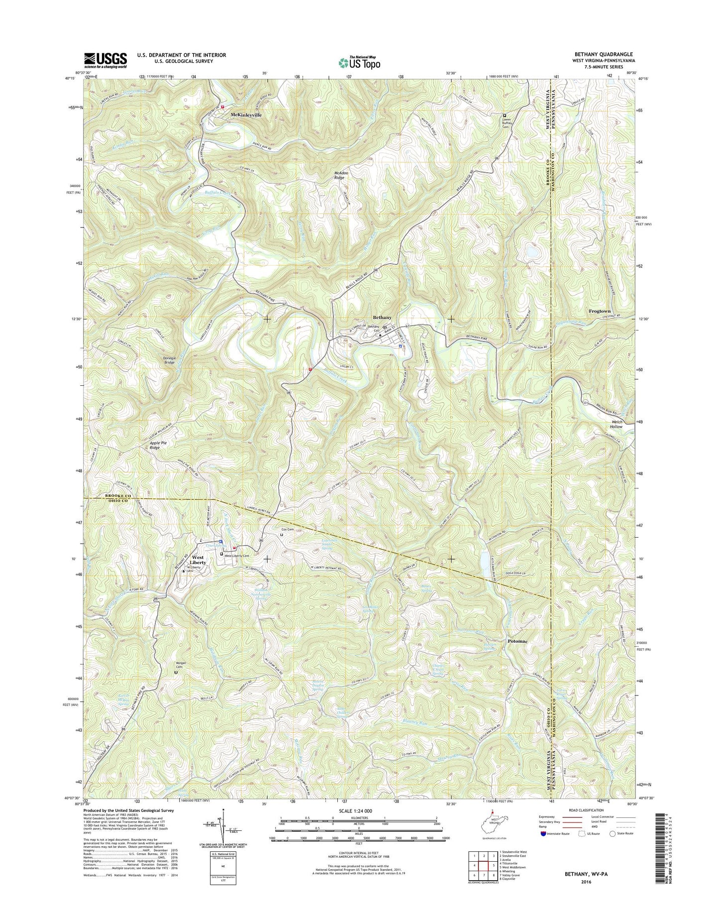
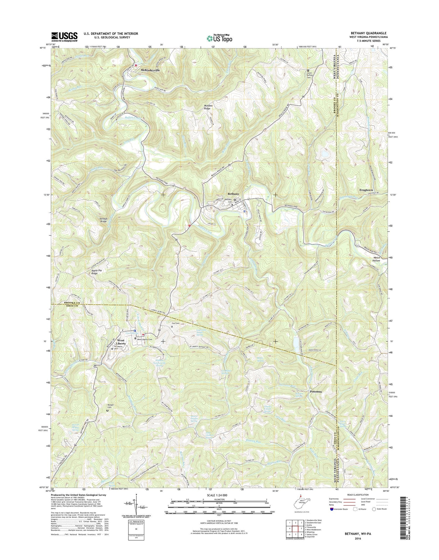
Bethany West Virginia US Topo Map
Couldn't load pickup availability
2019 topographic map quadrangle Bethany in the states of West Virginia, Pennsylvania. Scale: 1:24000. Based on the newly updated USGS 7.5' US Topo map series, this map is in the following counties: Brooke, Ohio, Washington. The map contains contour data, water features, and other items you are used to seeing on USGS maps, but also has updated roads and other features. This is the next generation of topographic maps. Printed on high-quality waterproof paper with UV fade-resistant inks.
Quads adjacent to this one:
West: Tiltonsville
Northwest: Steubenville West
Northeast: Avella
East: West Middletown
Southeast: Claysville
South: Valley Grove
Southwest: Wheeling
Contains the following named places: Alexander Campbell Mansion, Apple Pie Ridge, Asher Childers Spring, Bauer Spring, Bellview Campground, Bethany, Bethany College, Bethany Police Department, Bethany Post Office, Bethany Primary School, Bethany Volunteer Fire Department Station 20, Blayney Run, Borough of West Alexander, Boyd, Brashears Run, Buffalo District, Camp Run, Cascade Run, Castleman Run, Castleman Run Church, Castleman Run Wildlife Management Area, Castlemans Run Lake Dam, Charles E Hunt Spring, Church of Christ, Court Spring, Cox Cemetery, Crupe Run, Curtis Run, Dog Run, Donegal Bridge, Dunsfort, Earl D McKay Spring, Ferry Run, Fred Foster Spring, Frogtown, Garrison Run, Gist School, Grog Run, Harden Spring, Herbert Minch Spring, Hogtan Run, Howard Bachman Spring, Hukill Run, Hunt Spring, Irwin Roger Spring, James Loew Spring, Kimlin Run, Lawrence Sonda Spring, Leffler School, Leo Miller Spring, Logan Run, Longs Run, Lower Buffalo Cemetery, McAdoo Ridge, McKinleyville, McKinleyville School, McKinleyville Volunteer Fire Department, Melvin Dayton Spring, Mingo Run, Morgan Cemetery, Murray Run, North Prong, Old Bethany Church, Old Main, Palmer School, Pierce Run, Potomac, Rices Run, Sanford Midcap Spring, Stone Chapel Church, Stotts Run, Sugarcamp Run, Titt Run, Town of Bethany, Town of West Liberty, Weidman Run, Welch Hollow, Welch Run, Wellsburg District, West Liberty, West Liberty Cemetery, West Liberty Elementary School, West Liberty Police Department, West Liberty Presbyterian Church, West Liberty University, West Liberty Volunteer Fire Department, WGLZ-FM (West Liberty), William Summerville Spring, WVBC-FM (Bethany), WVNP-FM (Wheeling), ZIP Codes: 26032, 26074