MyTopo
Steubenville West Ohio US Topo Map
Couldn't load pickup availability
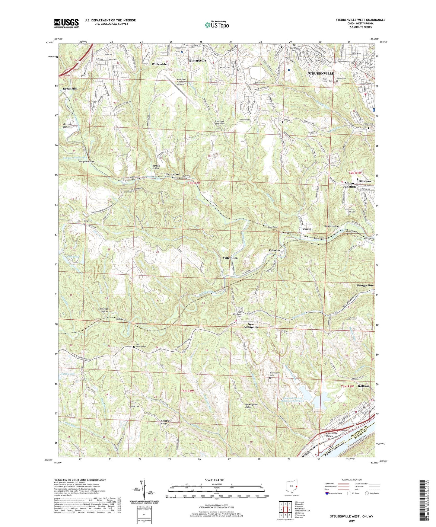
2023 topographic map quadrangle Steubenville West in the state of Ohio. Scale: 1:24000. Based on the newly updated USGS 7.5' US Topo map series, this map is in the following counties: Jefferson, Brooke. The map contains contour data, water features, and other items you are used to seeing on USGS maps, but also has updated roads and other features. This is the next generation of topographic maps. Printed on high-quality waterproof paper with UV fade-resistant inks.
Quads adjacent to this one:
West: Smithfield
Northwest: Richmond
North: Knoxville
Northeast: Weirton
Southeast: Bethany
South: Tiltonsville
Southwest: Dillonvale
Contains the following named places: Acuity Specialty Hospital - Ohio Valley at Steubenville, Adams Tunnel, Ambulance Service, Bantam Ridge Elementary School, Barbers Hollow, Barbers Run, Beatty Park Number 1, Becker Highlands, Blockhouse Hollow, Blockhouse Run, Bnai Israel Cemetery, Brady Estates, Brentwood Estates, Brilliant, Brilliant Census Designated Place, Brilliant Elementary School, Brilliant Post Office, Brilliant Volunteer Fire Department, Buckingham Cemetery, Buckingham Ridge, Buckingham Ridge Church, Cardinal Fly Ash Retention Dam, Cardinal Fly Ash Retention Reservoir, Cardinal Power Plant, Cedar Lick Run, Central High School, Chestnut Ridge, Church of the United Brethren in Christ, City of Steubenville, Cross Creek Presbyterian Cemetery, Dogtown, Dry Fork, East View, Erwin Hollow, Fells, Fells Post Office, Fernwood, Fernwood Post Office, Fernwood State Forest, First Baptist Church of Steubenville, First Church of the Nazarene, Fishersville, Forest View, Fort Steuben Mall Shopping Center, Georges Run, Georges Run Post Office, Georges Run School, Glendwell, Gospel Hall Church, Gould, Gould Post Office, Gould Tunnel, Grace Evangelical Lutheran Church, Green Acres, Gungeon Hollow Run, Gunyon Hollow, Harding Middle School, Harding Stadium, Harts Shopping Center, Hill Cemetery, Hillndale Volunteer Fire Department, Hills Elementary School, Hillsboro, Hollywood Addition, Hollywood Shopping Center, Holy Rosary Catholic Church, Holy Rosary School, Hunter Tunnel, Jefferson County Airpark, Jefferson Heights, Kolmont, Kolmont Community Church, La Belle View Church of Christ, La Belle View United Methodist Church, Lake Betsy, Life Line Hospital, Lincoln Heights, Lincoln School Number 1, Lincoln School Number 2, Little Salt Run, Long Cemetery, Long Run, Long Run School, Malabu Lake, Malabu Lake Dam, McCollough Childrens Home, McIntyre Creek, McKinley Elementary School, Mingo Sportsmens Club Lake Number, Mount Calvary Cemetery, New Alexandria, New Alexandria Cemetery, New Alexandria Elementary School, New Alexandria Post Office, New Alexandria Volunteer Fire Department, Ohio State Highway Patrol - Steubenville Patrol Post, Oliver Cemetery, Oliver Tunnel, Pleasant Heights, Plum Run, Polecat Hollow, Possum Hollow Run, Raynes Church, Reeds Mill, Reeds Mills Post Office, Riddles Run, Roosevelt School, Saint John Community Arena, Saint John Medical Center Heliport, Saint Pius the Tenth School, Schiappa Memorial Library, Slab Run, Slabcamp Creek, Spahns Addition, Stark School, Starkdale Presbyterian Church, Steubenville, Steubenville Country Club, Steubenville Fire Department Pleasant Heights Station 3, Steubenville Seventh Day Adventist Church, Stuart Manor, Sunshine Park, Swickards Addition, Tent Church Cemetery, Township of Cross Creek, Township of Steubenville, Township of Wells, Trinity Medical Center East, Trinity Medical Center West, Union Cemetery, Valley Glen, Village of New Alexandria, Wells Run, Winterdale, Wintersville Baptist Temple, Wintersville Elementary School, Wintersville United Methodist Church, Wintersville Wastewater Treatment Plant, ZIP Codes: 43913, 43938, 43953