MyTopo
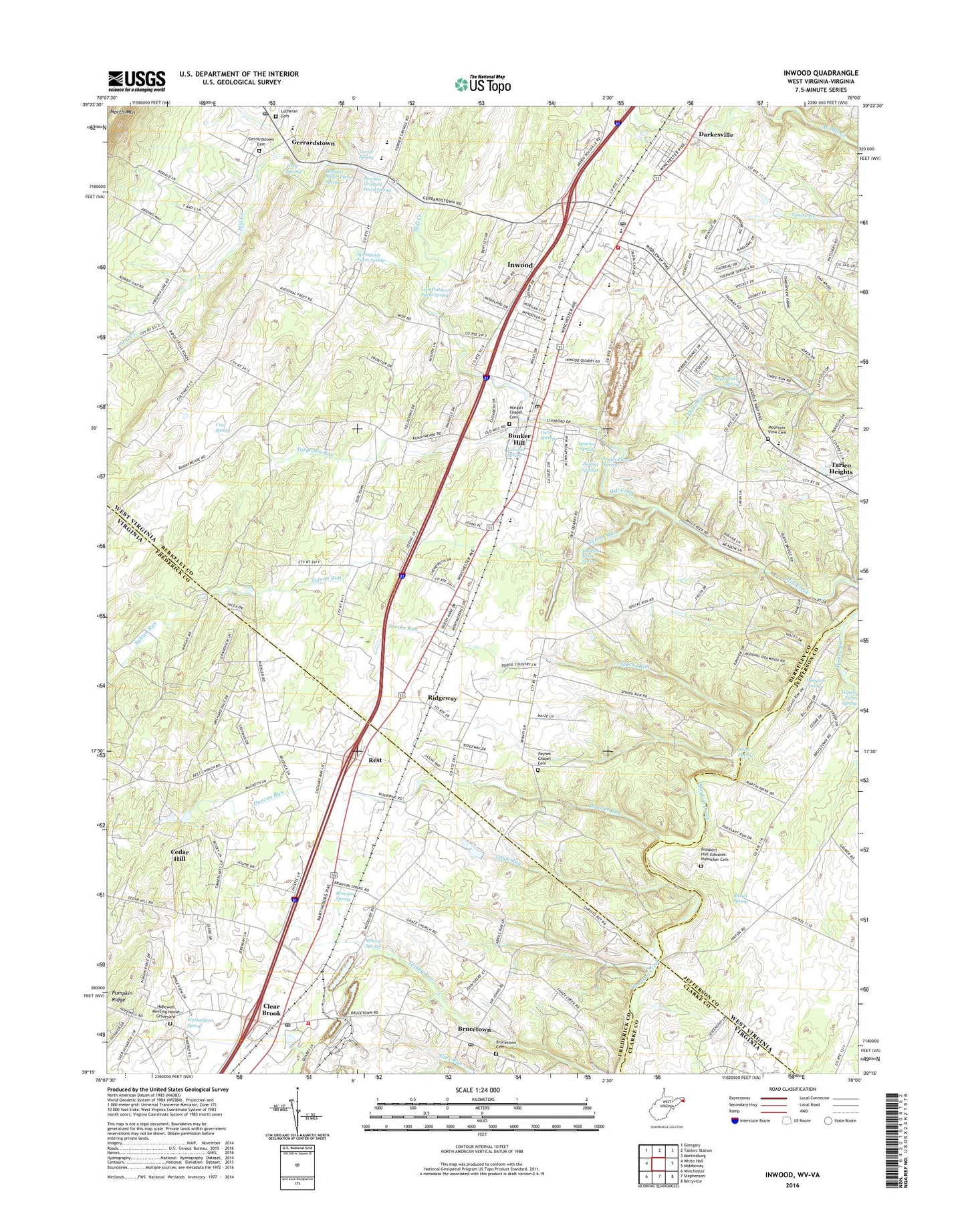
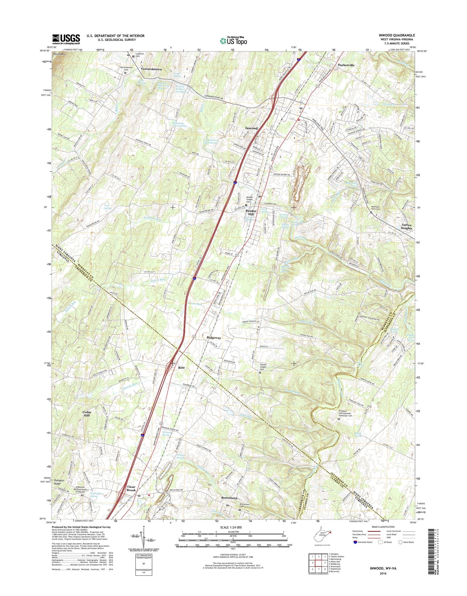
Inwood West Virginia US Topo Map
Couldn't load pickup availability
2019 topographic map quadrangle Inwood in the states of West Virginia, Virginia. Scale: 1:24000. Based on the newly updated USGS 7.5' US Topo map series, this map is in the following counties: Berkeley, Frederick, Jefferson, Clarke. The map contains contour data, water features, and other items you are used to seeing on USGS maps, but also has updated roads and other features. This is the next generation of topographic maps. Printed on high-quality waterproof paper with UV fade-resistant inks.
Quads adjacent to this one:
West: White Hall
Northwest: Glengary
North: Tablers Station
Northeast: Martinsburg
East: Middleway
Southeast: Berryville
South: Stephenson
Southwest: Winchester
Contains the following named places: Apple View Estates, Berkeley County Emergency Ambulance Authority South Station Unit 98, Boiling Springs, Boyer Farm Spring, Branson Spring, Bransons School, Brucetown, Brucetown Cemetery, Brucetown Census Designated Place, Brucetown Post Office, Brucetown School, Brucetown United Methodist Church, Bunker Hill, Bunker Hill Elementary School, Bunker Hill Historic District, Bunker Hill Post Office, Bunker Hill Presbyterian Church, Carter Ford, Carter Spring, Cedar Hill, Cedar Hill School, Charles Crim Spring, Christ Episcopal Church, Clear Brook, Clear Brook Post Office, Clearbrook Park, Clearbrook Presbyterian Church, Cool Spring, Coyle Run, Darkesville, Darkesville Historic District, Douglas Miller Farm Spring, Duncan Run, Eastern Panhandle Christian Academy, Edgewood Manor, First Baptist Church, Frederick County Fire and Rescue Department Station 13 - Clear Brook Volunteer Fire and Rescue, Gerrardstown, Gerrardstown Cemetery, Gerrardstown Elementary School, Gerrardstown Post Office, Gerrardstown Presbyterian Church, Gordondale, Grace Church, Grade School, Grey Spring, Gum Spring, Hopewell Meeting House Graveyard, Hopewell Meetinghouse, Inwood, Inwood Census Designated Place, Inwood Post Office, Inwood Primary School, Lee Whitacore Farm Spring, LeFevre Spring, Lemons Spring, Lutheran Cemetery, Mill Creek Historic District, Mill Creek Intermediate School, Morgan Chapel, Morgan Chapel Cemetery, Mount Olive Church, Mount Tabor Church, Mountain Ridge Intermediate School, Mountain View Cemetery, Mountain View Church, Musselman High School, Musselman Middle School, Opequon Spring, Payne Chapel, Paynes Chapel Cemetery, Peach Orchard Inn Farms, Peerless Orchard Farm Spring, Phoenix Mill, Pine Orchard School, Porter Farm Spring, Prospect Hall-Edwards-Hunsicker Cemetery, Pumpkin Ridge, Reese Mill, Rest, Rest United Methodist Church, Ridge School, Ridgeway, Ridgeway School, Russel Spring, Saint Johns Church, Shaulls Ford, Shenandoah District, Silver Spring, South Berkeley Volunteer Fire Department, Specks Run, Springvale Farm Spring, Sylvan Retreat School, Sylvan Run, Tarico Heights, Taylors Airport, Torytown Run, Turkey Run, Walkers School, Washington Spring, Wesley Church, West Virginia Division of Forestry Berkeley County Field Office, Whetzel Spring, Woodbine Church, Woodbine School, ZIP Codes: 22624, 25413