MyTopo
Berryville Virginia US Topo Map
Couldn't load pickup availability
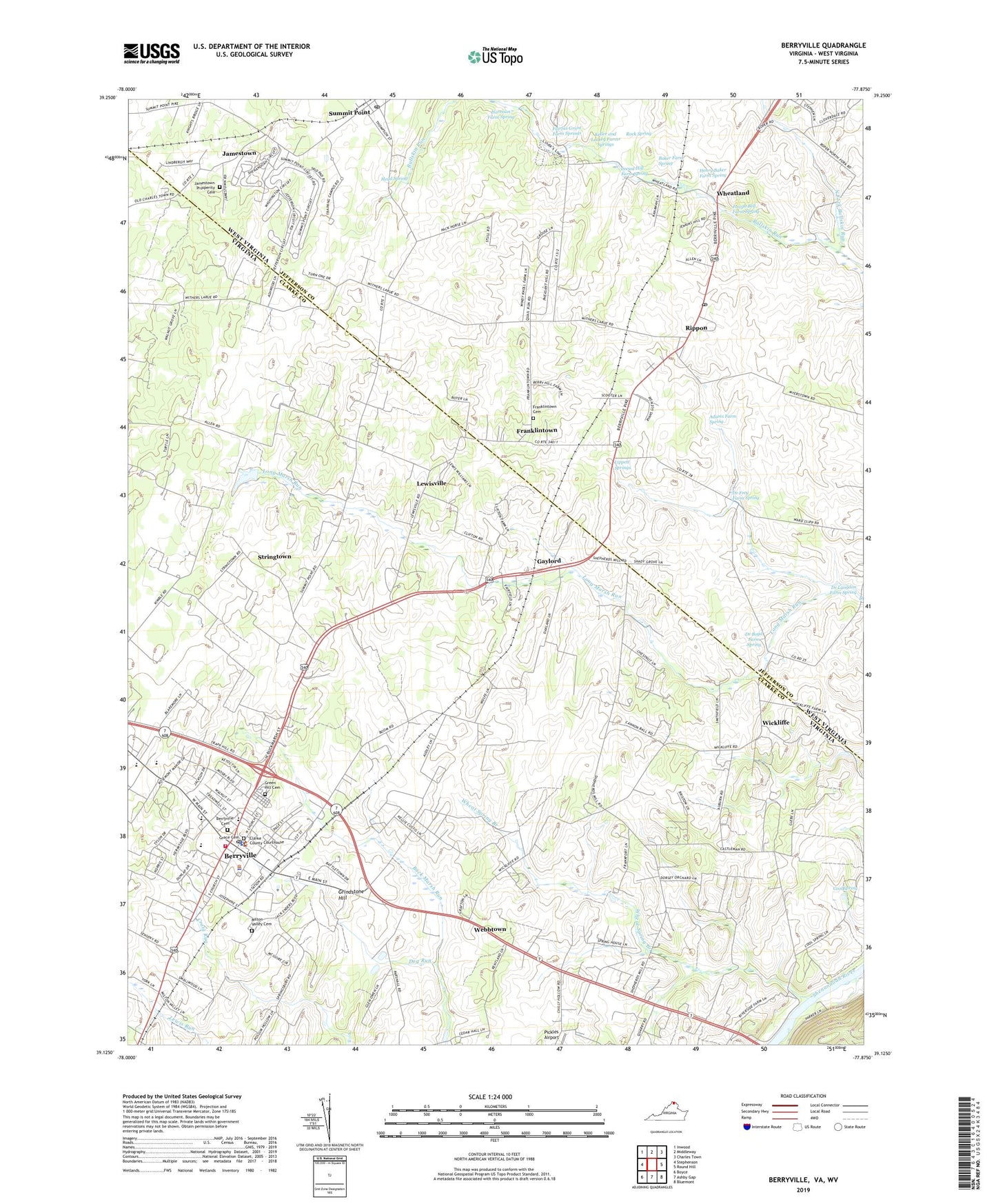
2022 topographic map quadrangle Berryville in the states of Virginia, West Virginia. Scale: 1:24000. Based on the newly updated USGS 7.5' US Topo map series, this map is in the following counties: Clarke, Jefferson. The map contains contour data, water features, and other items you are used to seeing on USGS maps, but also has updated roads and other features. This is the next generation of topographic maps. Printed on high-quality waterproof paper with UV fade-resistant inks.
Quads adjacent to this one:
West: Stephenson
Northwest: Inwood
North: Middleway
Northeast: Charles Town
Southeast: Bluemont
South: Ashby Gap
Southwest: Boyce
Contains the following named places: Adams Farm Spring, Anchorage Estate, Apple Glen, Arcadia Farm, Auburn Farms, Audley Estate, Baker Farm Spring, Balclutha Estate, Battletown, Berryville, Berryville Baptist Church, Berryville Cemetery, Berryville District, Berryville Historic District, Berryville Police Department, Berryville Post Office, Berryville Presbyterian Church, Berryville Primary School, Berryville Town Hall, Berryville-Clarke County Industrial Park, Bethel Church, Beulah Church, Bloomfield Estate, Blue Ridge Estates, Bradfield, Buck Marsh Church, Buck Marsh Run, Buckmarsh District, Cedar Grove Estate, Clarke County Courthouse, Clarke County Emergency Services, Clarke County Fairgrounds, Clarke County High School, Clarke County Library, Clarke County Sheriff's Office, Clermont Estate, Clifton Estate, Cool Spring, Crown Estates, D G Cooley Elementary School, Dr Boyd Farm Spring, Dr Frey Farm Spring, Dr Langdon Farm Spring, Duncan Memorial Methodist Church, Elmington Estate, Fairfax Grant Farm Springs, Fairfield, Fairfield Estate, Franklintown, Franklintown Cemetery, Frosts Mill Estate, Gaylord, Gaylord Post Office, Grace Cemetery, Grace Episcopal Church, Grafton School, Green Hill Cemetery, Green Hill Estate, Grindstone Hill, Harrison Farm Spring, Head Spring, Henry Baker Farm Spring, Holy Cross Monastery, Jamestown, Jamestown Prosperity Cemetery, John H Enders Volunteer Fire Company and Rescue Squad, Johnson - Williams Middle School, Johnson-Williams Middle School, Joseph Bell Farm Spring, Kabletown District, Keller and Lackey Farms Springs, Kinfield Estates, Lang Syne Estate, Lewisville, Lippett Springs, Locust Hill Farm Spring, Longmarsh Acres, Mannsfield Estate, Mantua Estate, Marvin Chapel, Melrose Estate, Middle Farm Estate, Milton Valley Cemetery, Monterey Estate, Morgan Spring Estate, Mosby Museum, Mount Airy Church, North Fork Bullskin Run, Norwood, Pigeon Hill, Poplimento Estate, Prospect Hill Estate, Prosperity Church, Rippon, Rippon Post Office, Riverside Estate, Rixey Moore Memorial Park, Rock Spring, Rockcroft, Rose Hill Nursing Home, Rosemont Estate, Runnymede Estate, Saint Johns Church, Saint Johns Episcopal Church, Saint Lukes Baptist Church, Saint Marys Episcopal Church, Saint Peters Baptist Church, Smithfield Estate, Soldiers Rest, South Jefferson Public Library, Stringtown, Summit Point, Summit Point Post Office, Summit Point Raceway Ambulance, Supreme Council of the House of Jacob, Town of Berryville, Trapp Hill, Treadwell, Villa Larue Estate, Vista Estates, Webbtown, Weehaw Estate, Wheat Spring Branch, Wheatland, Wickliffe, Wickliffe Church, Wilson, Zion Church, ZIP Codes: 22611, 25446