MyTopo
Lewisburg West Virginia US Topo Map
Couldn't load pickup availability
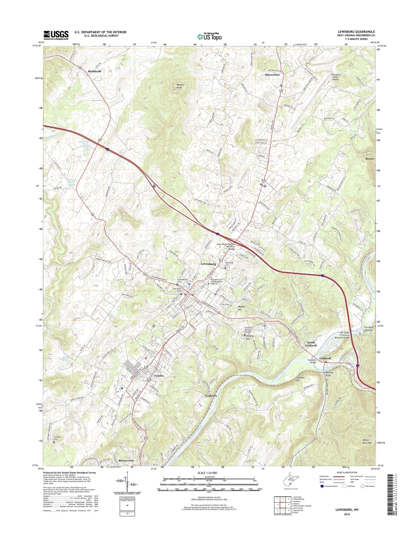
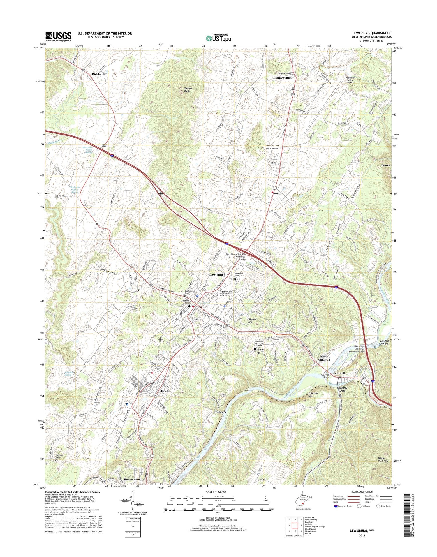
2019 topographic map quadrangle Lewisburg in the state of West Virginia. Scale: 1:24000. Based on the newly updated USGS 7.5' US Topo map series, this map is in the following counties: Greenbrier. The map contains contour data, water features, and other items you are used to seeing on USGS maps, but also has updated roads and other features. This is the next generation of topographic maps. Printed on high-quality waterproof paper with UV fade-resistant inks.
Quads adjacent to this one:
West: Asbury
Northwest: Cornstalk
North: Williamsburg
Northeast: Anthony
East: White Sulphur Springs
Southeast: Glace
South: Ronceverte
Southwest: Fort Spring
Contains the following named places: Arbuckle School, Balm of Gilead School, Bowling Elementary School, Bowling High School, Buckingham Acres, Caldwell, Caldwell Bridge, Caldwell Post Office, Calvary Baptist Church, Calvary United Methodist Church, Cat Rock Hollow, Cedar Knoll Trailer Park, Central District, Central School, Church of Christ, City of Lewisburg, City of Ronceverte, Coalbank School, Coffman Cemetery, Coffman Hill, Coffman Hill Chapel, Community Church, Confederate Cemetery, Crowfields, Dogwood Heights, Eastern Greenbrier Middle School, Edgewood Chapel, Edgewood School, Elmhurst, Fair Oaks Trailer Park, Fairlea, Fairlea Census Designated Place, Fairlea Volunteer Fire Department, Fairview School, Fort Union, Free Church, Fuller Trailer Park, Gary Wayne Martini Memorial Bridge, George School, Greenbrier College for Women, Greenbrier County Courthouse, Greenbrier County Emergency Ambulance, Greenbrier County Library, Greenbrier County Sheriffs Office, Greenbrier East High School, Greenbrier Episcopal School, Greenbrier Memorial Gardens, Greenbrier Military Academy, Greenbrier Training Center, Greenbrier Valley Airport, Greenbrier Valley Fairground, Greenbrier Valley Mall Shopping Center, Greenbrier Valley Medical Center, Greenbrier Valley School, Hilltop Baptist Church, Holliday School, Holliday-Lewis School, Hominy Hill, Howard Creek, Humana Hospital-Greenbrier Valley, John Weslty United Methodist Church, Johnson Spring, Lewis Spring, Lewis Theatre, Lewisburg, Lewisburg Baptist Acadamy, Lewisburg Elementary School, Lewisburg Elks Country Club Golf Course, Lewisburg High School, Lewisburg Historic District, Lewisburg Maternity Hospital, Lewisburg Police Department, Lewisburg Post Office, Lewisburg United Methodist Church, Lewisburg Volunteer Fire Department Headquarters, Lewisburg Volunteer Fire Department Station 1, Lewisburg Volunteer Fire Department Station 2, Liberty Baptist Church, Little Country Church, Livesay School, Maple Street Historic District, Marquee Cinemas - Seneca Showcase, Mathews Ford, Maxwelton, Maxwelton Post Office, McClain Church, Milligan Creek, Monroe Draft, Monroe Draft School, Morlunda, Morlunda Farms Spring, Mount Tabor Baptist Church, Mountain View Estates, New Covenant Sanctuary Church of God, North Caldwell, Old Stone Cemetery, Old Stone Presbyterian Church, PFC Ralph E Pomeroy Memorial Bridge, Pratt Mining Heliport, Red Oaks Shopping Center, Richlands, Rolling Hills, Ronceverte Elementary School, Rosewood Cemetery, Saint James Episcopal Church, Savannah Mills, Shuck Memorial Baptist Church, Solomon Springs School, South Church Street Historic District, Teaberry, Trillium Performing Arts Collective, Underwood Estates, Wagner Hill, Walnut Hills, Weaver Knob, West Virginia School of Osteopathic Medicine, West Virginia State Police Troop 6 - Lewisburg Detachment, Whitcomb, White School, WRON-AM (Ronceverte), ZIP Code: 24901