MyTopo
Looneyville West Virginia US Topo Map
Couldn't load pickup availability
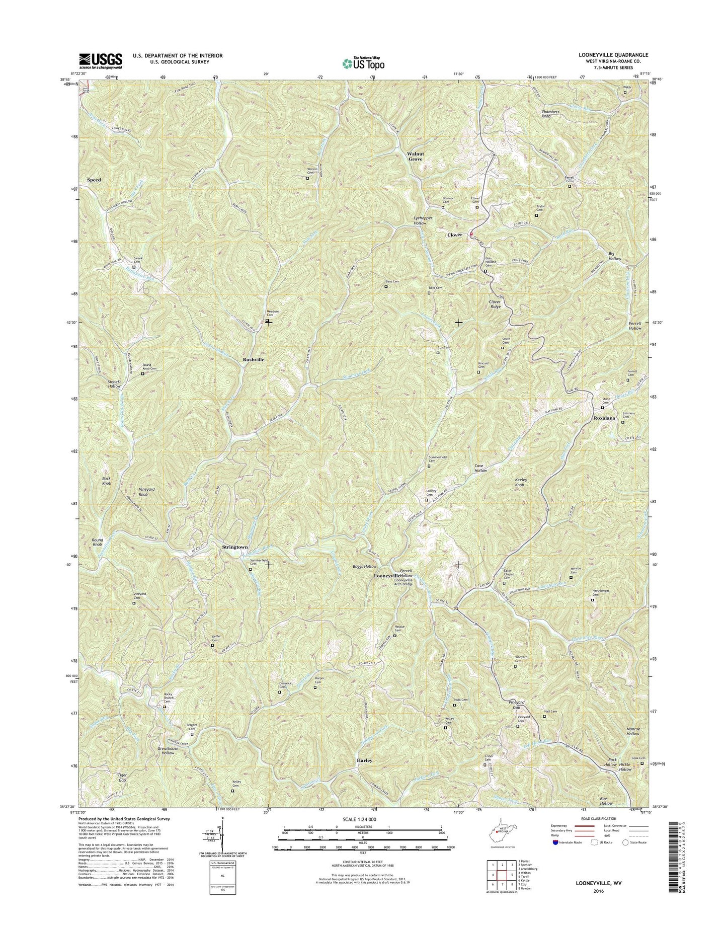
2023 topographic map quadrangle Looneyville in the state of West Virginia. Scale: 1:24000. Based on the newly updated USGS 7.5' US Topo map series, this map is in the following counties: Roane. The map contains contour data, water features, and other items you are used to seeing on USGS maps, but also has updated roads and other features. This is the next generation of topographic maps. Printed on high-quality waterproof paper with UV fade-resistant inks.
Quads adjacent to this one:
West: Walton
Northwest: Peniel
North: Spencer
Northeast: Arnoldsburg
East: Tariff
Southeast: Newton
South: Clio
Southwest: Kettle
This map covers the same area as the classic USGS quad with code o38081f3.
Contains the following named places: Banner Church, Banner School, Bays Cemetery, Bay's Chapel United Methodist Church, Beelick Run, Big Hollow, Boggs Hollow, Brannon Cemetery, Buck Knob, Buffalolick, Cave Hollow, Chambers Fork, Chambers Knob, Chambers School, Clarkson Fork, Claylick Run, Clover, Clover - Roane Volunteer Fire Department, Clover Cemetery, Clover Post Office, Clover Ridge, Clover Ridge Oil Field, Coal Lick Run, Coalstone Run, Coe - Holland Cemetery, Cook Cemetery, Cox Cemetery, Cranesnest Run, Criner Cemetery, Dalton Chapel, Deverick Cemetery, Dry Fork, Eastern District, Eplin Chapel Cemetery, Epling Chapel, Fairview School, Ferrell Cemetery, Ferrell Hollow, Flat Fork, Flat Fork Church, Greathouse Hollow, Hall Cemetery, Harley, Harper Cemetery, Hascue Cemetery, Hershberger Cemetery, Hickle Hollow, Hollywood Fork, Hundley Chapel, Jack Fork, Jackson Fork, Johnson Creek School, Keeley Knob, Keffer Cemetery, Kelley Cemetery, Kincaid Cemetery, Laurel Fork, Laurel Run, Lawsons Farm Lake Dam, Liberty Church, Looney Cemetery, Looneyville, Looneyville Arch Bridge, Looneyville Post Office, Lyehopper Hollow, Maldon Run, Meadows Cemetery, Millstone Run, Millstone School, Monroe Cemetery, Monroe Hollow, Mud Fork, Nida Cemetery, Oak Hill School, Oldham Lake Dam, Pad, Pad Fork, Red Knob Church, Roane County, Rock Hollow, Rocky Branch, Rocky Branch Cemetery, Rocky Branch Church, Roe Hollow, Round Knob, Round Knob Cemetery, Round Knob Run, Round Knob School, Roxalana, Rush Creek, Rush Creek Church, Rushville, Sergent Cemetery, Shad, Shamblings Mills, Shammon Branch, Showens Run, Simmons Cemetery, Sinnett Hollow, Slab Fork, Slab Fork Church, Smith Cemetery, Smith Run, Stalnaker School, Stone Cemetery, Stringtown, Stringtown Oil Field, Sugar Run, Summerfield Cemetery, Summers Fork, Swank Cemetery, Taylor Cemetery, Tiger Gap, Vineyard Cemetery, Vineyard Gap, Vineyard Knob, Vineyard Run, Walnut Grove, Watson Cemetery, Webb Cemetery, ZIP Code: 25259