MyTopo
Pond Creek West Virginia US Topo Map
Couldn't load pickup availability
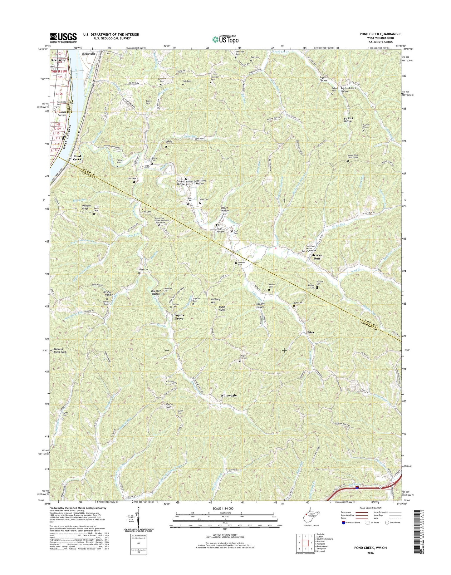
2023 topographic map quadrangle Pond Creek in the states of West Virginia, Ohio. Scale: 1:24000. Based on the newly updated USGS 7.5' US Topo map series, this map is in the following counties: Jackson, Wood, Meigs. The map contains contour data, water features, and other items you are used to seeing on USGS maps, but also has updated roads and other features. This is the next generation of topographic maps. Printed on high-quality waterproof paper with UV fade-resistant inks.
Quads adjacent to this one:
West: Portland
Northwest: Coolville
North: Lubeck
Northeast: South Parkersburg
East: Rockport
Southeast: Liverpool
South: Sandyville
Southwest: Ravenswood
This map covers the same area as the classic USGS quad with code o39081a6.
Contains the following named places: Alexander Cemetery, Anderson Cemetery, Anthony Hill, Armstrong Hollow, Bailey Run, Bear Run, Beatysville, Beatysville School, Bee Run, Bee Tree Hollow, Belleville, Belleville Lock and Dam, Belleville Locks and Dam, Big Rock Hollow, Boord Hollow, Boso Cemetery, Braham Cemetery, Brown Cemetery, Browning, Buckley Cemetery, Buzzard Roost Knob, Cabin Fork, Center Star School, Chapel Hill Cemetery, Chapel Hill Church, Cherry Grove School, Congrove Cemetery, Cove Run, Crooks Cemetery, DeLong Hollow, Dutch Ridge, Ebenezer Church, Elk Run, Fairfax Hollow, Flinn, Flinn Cemetery, Flinn Hollow, Flinn School, Ford, Ford Cemetery, Ford Church, Gunneltree Run, Hall Cemetery, Hogtrail Run, Isabelle Flinn Cemetery, Jerrys Run, Jerrys Run School, Jesse Run, Jordan Cemetery, Kirkhart Hollow, Lamps Cemetery, Lamps Run, Laurel Run, Left Fork Jesse Run, Left Fork Wolf Run, Liberty School, Little Pond Creek, Logston Cemetery, Logston Run, Lone Cedar School, Lone Star School, Long Run, Low Gap, Manganese, Mills Cemetery, Mount Olive Church, Mount Olive Church Cemetery, Mount Zion Church, Mount Zion United Methodist Church Cemetery, Mountain Flower School, Mozelle, Mud Lick, Oak Grove School, Olive Township Volunteer Fire Department and Emergency Medical Services Department, Ona School, Otter Run, Pennike Run, Phillips Cemetery, Pleasant Hill School, Pond Creek, Pond Creek Baptist Church, Pond Creek Baptist Church Cemetery, Pond Creek Volunteer Fire Department, Poplar School Hollow, Poplecat Hollow, Powers, Ralston School, Rawson Cemetery, Reedsville, Reedsville Cemetery, Reedsville Post Office, Right Fork Jesse Run, Right Fork Wolf Run, Rush Cemetery, Rush Run, Seebaugh Cemetery, Sellers Cemetery, Shafer Cemetery, Shafer Knob, Shafer School, Short Run, Simpson Church, Simpson United Methodist Church Cemetery, Slate Run, Slaven Branch, Smith Cemetery, Staats Cemetery, Sugarcamp Run, Sunshine School, Swain Cemetery, Temperance Chapel, The Slough, Thomas Run, Thomas Run School, Topins Grove, Twomery School, Twomey Cemetery, Utica, Valley Star School, Vanhorn Cemetery, Wade Cemetery, Whetstone School, White Cemetery, Willow Run, Willow Run School, Willowdale, Wolf Run, WRZZ-FM (Ravenswood), ZIP Codes: 26133, 26164