MyTopo
Sissonville West Virginia US Topo Map
Couldn't load pickup availability
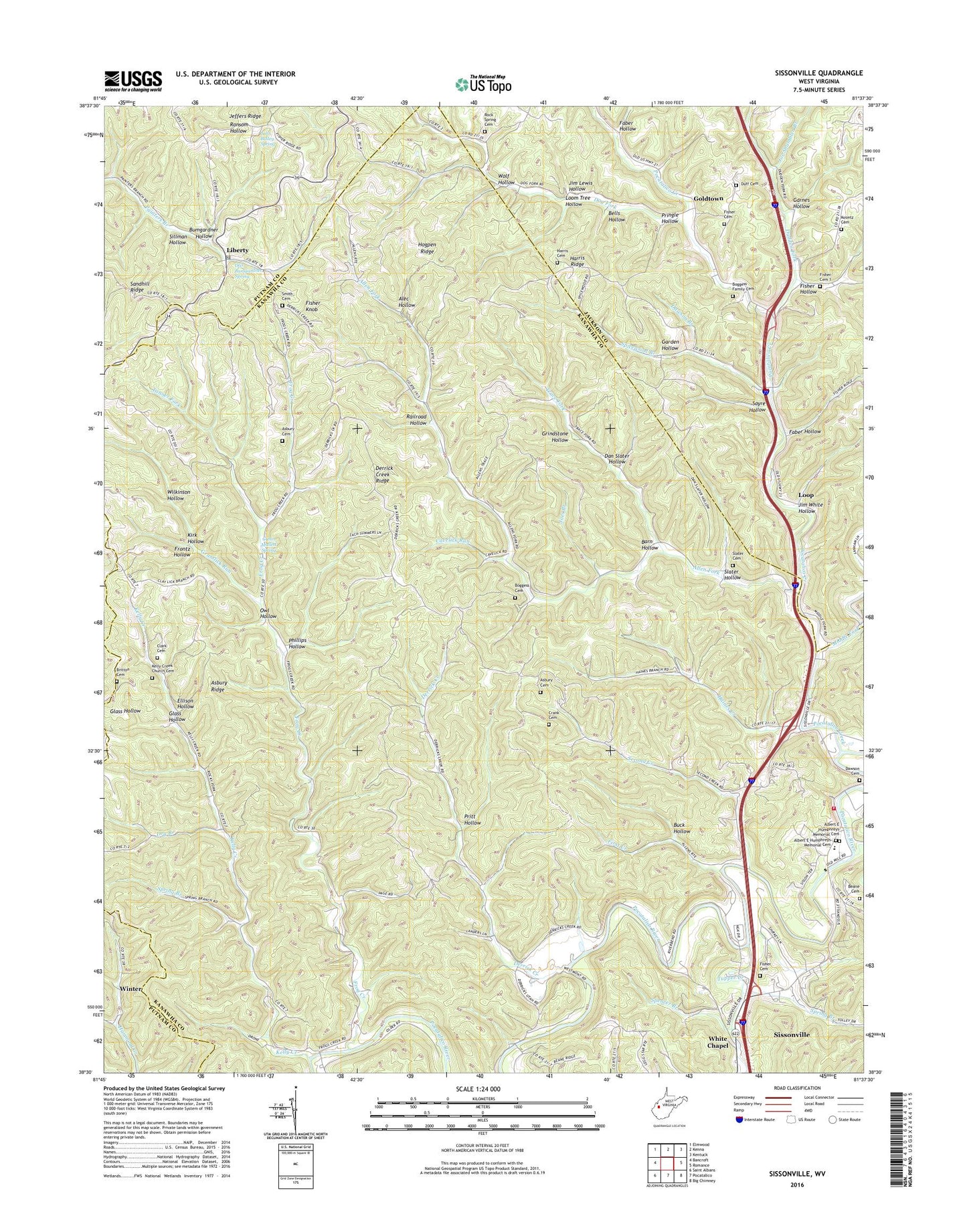
2023 topographic map quadrangle Sissonville in the state of West Virginia. Scale: 1:24000. Based on the newly updated USGS 7.5' US Topo map series, this map is in the following counties: Kanawha, Jackson, Putnam. The map contains contour data, water features, and other items you are used to seeing on USGS maps, but also has updated roads and other features. This is the next generation of topographic maps. Printed on high-quality waterproof paper with UV fade-resistant inks.
Quads adjacent to this one:
West: Bancroft
Northwest: Elmwood
North: Kenna
Northeast: Kentuck
East: Romance
Southeast: Big Chimney
South: Pocatalico
Southwest: Saint Albans
This map covers the same area as the classic USGS quad with code o38081e6.
Contains the following named places: Albert E Humphreys Memorial Cemetery, Albert E Humphreys Memorial Church, Alec Hollow, Allen Fork, Allens Chapel, Asbury Cemetery, Asbury Ridge, Asbury School, Barn Hollow, Bells Hollow, Betty L School, Boggess Cemetery, Boggess Family Cemetery, Bonham Chapel, Britton Cemetery, Buck Hollow, Bumgardner Hollow, Cavelick Run, Clark Cemetery, Crank Cemetery, Dan Slater Hollow, Dawson Branch, Dawson Cemetery, Derrick Creek, Derrick Creek Ridge, Dog Fork, Dry Branch, Dudden Fork, Duff Cemetery, Edgewood Country Club Golf Course, Ellison Hollow, Faber Hollow, First Creek, Fisher Cemetery, Fisher Chapel, Fisher Hollow, Fisher Hollow Cemetery, Fisher Knob, Fishers Church, Frog Creek, Frontz Hollow, Garden Hollow, Garnes Hollow, Glass Hollow, Glenn Mallett Spring, Goldtown, Grapevine Creek, Grasslick Run, Grindstone Hollow, Guiding Light Church, Haines Creek, Harris Cemetery, Harris Ridge, Hogpen Ridge, Jeffers Ridge, Jim Lewis Hollow, Jim White Hollow, Joe Shamblen Branch, Joes Branch, John Bailey Spring, John Beane Cemetery, Kelly Creek, Kelly Creek Church, Kelly Creek Church Cemetery, Kirk Hollow, Koontz Cemetery, Liberty, Liberty Post Office, Liberty School, Lonesome Low School, Loom Tree Hollow, Loop, Middle Fork, Millertown, Oak Grove Church, Otis Bumgardner Spring, Owl Hollow, Phillips Hollow, Pocatalico Creek, Point Harmony School, Pringle Hollow, Pritt Hollow, Railroad Hollow, Rock Spring Cemetery, Rock Spring Church, Sayre Hollow, Sayre School, Second Creek, Sillman Hollow, Sissonville, Sissonville Census Designated Place, Sissonville Elementary School, Sissonville Millertown Pocatalico and Guthrie Volunteer Fire Department Goff Station, Slater Cemetery, Slater Hollow, Smith Cemetery, Spencer Branch, Spicewood Branch, Spring Branch, Sugar Grove School, Tanner Fork, Trace Fork, Trace Fork Church, Tupper Creek, Unexpected School, White Chapel, Wilkinson Hollow, Winter, Wolf Hollow, ZIP Code: 25320