MyTopo
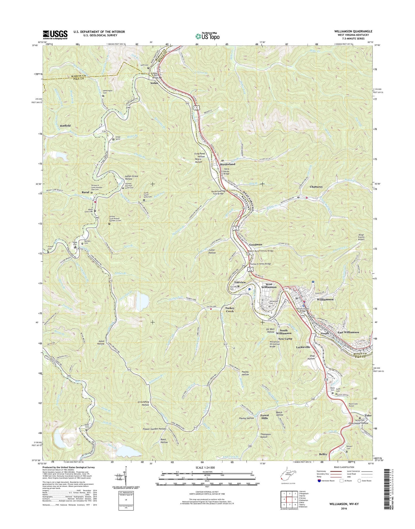
Williamson West Virginia US Topo Map
Couldn't load pickup availability
2023 topographic map quadrangle Williamson in the states of Kentucky, West Virginia. Scale: 1:24000. Based on the newly updated USGS 7.5' US Topo map series, this map is in the following counties: Mingo, Pike, Martin. The map contains contour data, water features, and other items you are used to seeing on USGS maps, but also has updated roads and other features. This is the next generation of topographic maps. Printed on high-quality waterproof paper with UV fade-resistant inks.
Quads adjacent to this one:
West: Varney
Northwest: Kermit
North: Naugatuck
Northeast: Myrtle
East: Delbarton
Southeast: Matewan
South: Belfry
Southwest: Meta
This map covers the same area as the classic USGS quad with code o37082f3.
Contains the following named places: Alley Branch, Appalachian First Response EMS, Becket Branch, Beech Hollow, Bent Branch, Bent Branch School, Big Canoe Branch, Big Creek, Big Creek Church, Black Cemetery, Blackberry Fork, Bnai Israel Temple, Borderland, Borderland Post Office, Borderland School, Borderland Tug Fork Bridge, Buckhorn Branch, Buffalo Creek, Burgett Branch, Burris Post Office, Cain Fork, Calvary Baptist Church, Caney Fork, Chaffin Branch, Chattaroy, Chattaroy Census Designated Place, Chattaroy Elementary School, Chattaroy Post Office, Chattaroy Volunteer Fire Department, Church of Christ, Churchouse Hollow, City of Williamson, Cold Fork, Coleman Branch, Cow Branch, Dans Branch, Dick Fork, Dubois Public School, East End Public School, East Williamson, East Williamson Baptist Church, Fairview, Fairview Cemetery, First Baptist Church, First Christian Church, First Mount Zion Baptist Church, First Presbyterian Church, First United Methodist Church, Flower Garden Hollow, Forest Hills, Forest Hills Post Office, Fraley Cemetery, Frog Pond Hollow, Goff Branch, Goff Cemetery, Goodman, Goody, Goody Post Office, Groundhog Hollow, Happy Valley Camp, Hatfield, Hatfield Post Office, Hatfield Railroad Station, Hatfield Volunteer Fire Department, Hayes Lowe Cemetery, Hurricane Branch, Indian Grave Hollow, Johns Hollow, Julius Branch, Kate Camp Branch, Leckieville, Left Fork Lick Branch, Left Fork Miller Creek, Left Fork Spring Branch, Lick Branch, Little Rosie Church, Long Fork, Low Gap Fork, Lowe Branch, Lowe School, Lower Lick Branch, May Branch, McCoy Branch, Meetinghouse Branch, Mill Fork, Millstone Branch, Mingo County Airport, Mingo County Courthouse, Mingo County Jail, Mingo County Sheriff's Office, Mingo Memorial Building, Money Branch, Mouth of Long Fork, Mouth of Pond Post Office, Murphy Branch, Negro Hollow, New Camp, Nolan, Nolan Elementary School, Nolan Post Office, Nolan Toll Bridge, Nosben Branch, Nosben Fork, Oil Well Hollow, Old Field Branch, Old Pond Church, Oranoco Mine, Orrison Lowe Branch Number 2 Cemetery, Orrison R Lowe Number One Cemetery, Parker Fork, Pauley Hollow, Peg Fork, Pilgrim Holiness Church, Point Truth Church, Pond Creek, Pond Creek Tunnel, Rank Fork, Rattlesnake Fork, Reed Hollow, Right Fork Lick Branch, Road Fork, Road Fork School, Robert Byrd Freeway Bridge, Rogers Park, Rogers Park / Turkey Creek Volunteer Fire Department, Rogers Park Church, Romans Cemetery, Rough Fork, Runyon Cemetery, Runyon Post Office, Rural, Rural Post Office, Sacred Heart Catholic School, Sacred Heart Roman Catholic Church, Saint James African Methodist Episcopal Church, Saint Pauls Episcopal Church, Salter Branch School, Sand Lick, Scott Branch, Scott Cemetery, Shiloh Church, Shop Hollow, Sidney Division, Slater Branch, Slatter Branch, South Fork Buffalo Creek, South Side Mall Shopping Center, South Williams School, South Williamson, South Williamson Census Designated Place, Southern West Virginia Community / Technical College - Williamson Campus, Spring Branch, Stat Ambulance Service, Stepp - Vance Cemetery, Stepp Branch, Stepp Cemetery, Steve Hardin Bridge, Sugartree Creek, Sukey Branch, Sukey Fork, Swinge Camp Branch, Tandy Sester Alley Cemetery, Taylor Fork, Thomas H Farley Bridge, Thomas Shermon Lowe Cemetery, Thompson Hollow, Toler, Toler Census Designated Place, Triumph Baptist Church, Tug Valley Appalachian Regional Medical Center, Turkey Branch School, Turkey Creek, Turkey Creek Consolidated School, Turkey Creek Post Office, Turkey Creek School, Upper Lick Branch, Varney Cemetery, Varney School, Victoria Court, Vinson Street Bridge, WBTH-AM (Williamson), Weddington Cemetery, West Virginia State Police Troop 5 - Williamson Detachment, West Williamson, West Williamson Elementary School, White Post Office, Whitepost School, Williamson, Williamson 4th Avenue Bridge, Williamson Branch, Williamson Cemetery, Williamson Christian School, Williamson City Hall, Williamson Creek, Williamson District, Williamson Fire Department, Williamson High School, Williamson Memorial Hospital, Williamson Middle School, Williamson PK - 8 School, Williamson Police Department, Williamson Post Office, Williamson Public Library, Williamson Terrace, WXCC-FM (Williamson), ZIP Codes: 25661, 41503, 41514, 41527