MyTopo
Winfield West Virginia US Topo Map
Couldn't load pickup availability
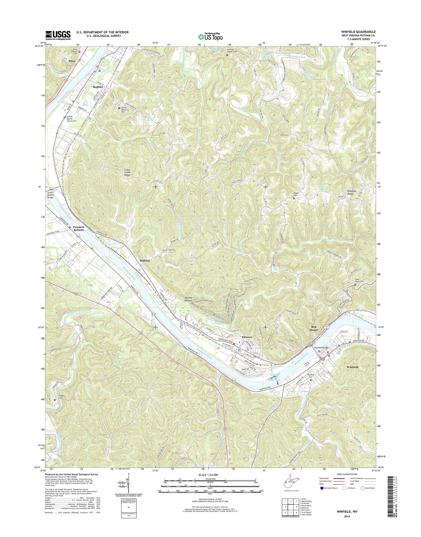
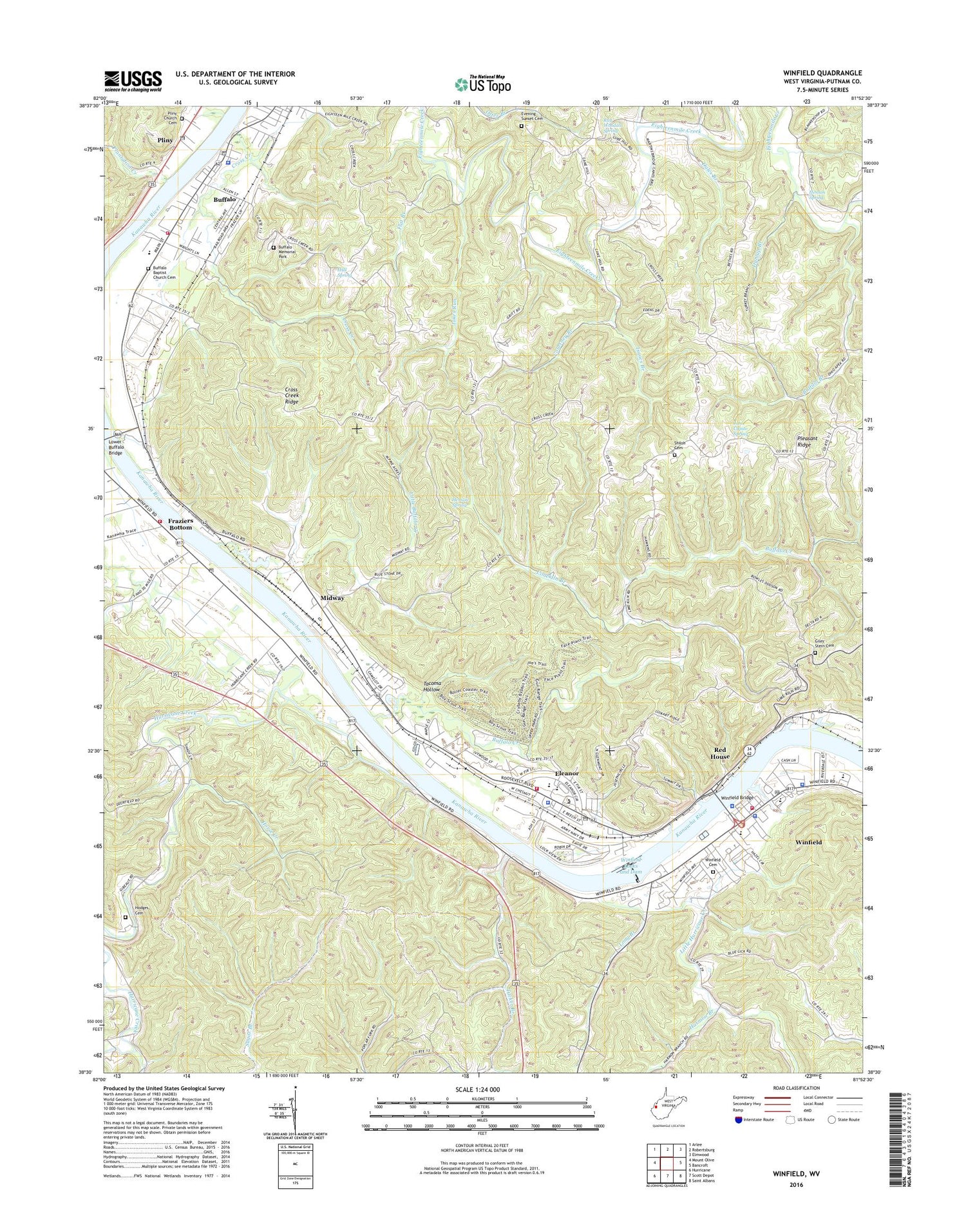
2019 topographic map quadrangle Winfield in the state of West Virginia. Scale: 1:24000. Based on the newly updated USGS 7.5' US Topo map series, this map is in the following counties: Putnam. The map contains contour data, water features, and other items you are used to seeing on USGS maps, but also has updated roads and other features. This is the next generation of topographic maps. Printed on high-quality waterproof paper with UV fade-resistant inks.
Quads adjacent to this one:
West: Mount Olive
Northwest: Arlee
North: Robertsburg
Northeast: Elmwood
East: Bancroft
Southeast: Saint Albans
South: Scott Depot
Southwest: Hurricane
Contains the following named places: Adda Church, Bear Branch, Buffalo, Buffalo Academy, Buffalo Baptist Cemetery, Buffalo Branch, Buffalo Branch Putnam County Library, Buffalo Creek, Buffalo Elementary School, Buffalo High School, Buffalo Memorial Park, Buffalo Police Department, Buffalo Post Office, Buffalo Presbyterian Church, Buffalo Town Hall, Buffalo Volunteer Fire Department, Buffalo-Union District, Camelot Village Mobile Home Park, Camp Buffalo, Courtney Branch, Cross Creek, Cross Creek Church, Cross Creek Ridge, Cross Creek School, Dales Branch, Dunlap Branch, Dunlap Chapel, Eleanor, Eleanor Branch Putnam County Library, Eleanor Industrial Park, Eleanor Plaza Shopping Center, Eleanor Police Department, Eleanor Post Office, Eleanor Town Hall, Eleanor Volunteer Fire Department, Evening Sunset Cemetery, First Baptist Church of Eleanor, Flat Branch, Fraziers Bottom, Fraziers Bottom Post Office, George Washington Elementary School, George Washington Middle School, Giles - Stern Cemetery, Harmon Branch, Henson Spring, Hodges School, Horse Creek, Hull Spring, Hurricane Creek, Indian Village, Isaacs Branch, Jakes Run, John Capito Spring, Limekiln Branch, Little Buffalo Creek, Little Hurricane Creek, Long Branch, Lower Buffalo Bridge, Lukes Branch, Meadowland Golf Course, Midway, Oak Ridge Church, Otter Branch Church, Peter Hodges Cemetery, Plantation Creek, Pleasant Ridge, Pleasant Valley Estates, Pliny, Pliny Church, Pliny Church Cemetery, Pliny Post Office, Poplar Fork, Putnam Career and Technical Center, Putnam County, Putnam County Courthouse, Putnam County Emergency Medical Services, Putnam County Sheriff's Office, Ray Woodall Spring, Red House, Riverdale Estates, Riverside Church, Robinson School, Roush Spring, Shiloh Cemetery, Shiloh Church, Tacoma Hollow, Town of Buffalo, Town of Eleanor, Town of Winfield, Tucker Branch, West Virginia State Police Troop 5 - Winfield Detachment, Westland Estates, Westvaco Sportsmans Club Lake Dam, White Star School, Winfield, Winfield Acres, Winfield Bridge, Winfield Cemetery, Winfield Elementary School, Winfield High School, Winfield Lock Dam Number 1, Winfield Locks and Dam, Winfield Middle School, Winfield Mobile Home Park, Winfield Police Department, Winfield Post Office, Winfield Public Water Supply Dam, Winfield Volunteer Fire Department Frazier Bottom Substation, Winfield Volunteer Fire Department Station 1, Woodbend Cove, ZIP Codes: 25033, 25070, 25168, 25213