MyTopo
Scott Depot West Virginia US Topo Map
Couldn't load pickup availability
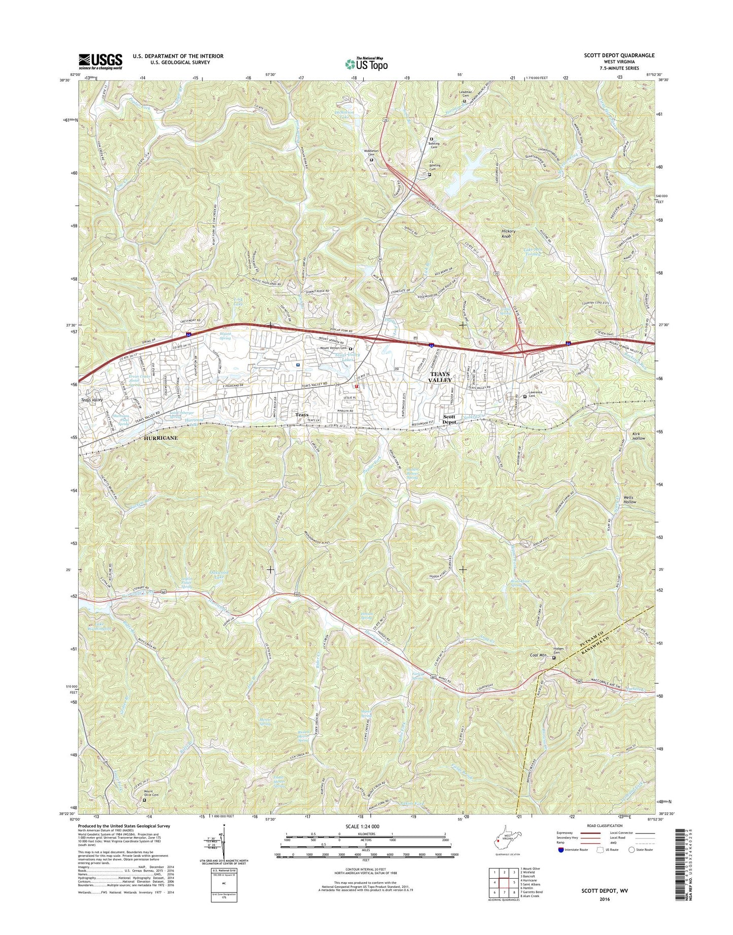
2023 topographic map quadrangle Scott Depot in the state of West Virginia. Scale: 1:24000. Based on the newly updated USGS 7.5' US Topo map series, this map is in the following counties: Putnam, Kanawha. The map contains contour data, water features, and other items you are used to seeing on USGS maps, but also has updated roads and other features. This is the next generation of topographic maps. Printed on high-quality waterproof paper with UV fade-resistant inks.
Quads adjacent to this one:
West: Hurricane
Northwest: Mount Olive
North: Winfield
Northeast: Bancroft
East: Saint Albans
Southeast: Alum Creek
South: Garretts Bend
Southwest: Hamlin
This map covers the same area as the classic USGS quad with code o38081d8.
Contains the following named places: Autumn Wynds, Belle Acres, Big Scary School, Black Lick Estates, Black Lick School, Bowling Cemetery, Bruce Hunt Spring, Buffs Branch, Calvary Baptist Academy, Camp Happy Valley, Candlewyck Place, Catholic Church of the Ascension, Charleston Area Medical Center Teays Valley Hospital, Cherry Grove, Cheyenne Valley, Coal Mountain, Colonial Gardens, Cottle Spring, Country Villas, Cow Creek, Crooked Creek, Dickinson Lake, District 2, Dogwood Estates, Englewood Estates, Ensell Mercer Spring, Ervan Coiner Junior Spring, Fairview, Fairway Gardens, Farley Spring, Fields Brook, Good Shepherd Southern Baptist Church, Grobes Branch, Heavens Gateway Cemetery, Henson Spring, Hickory Hill, Hickory Knob, Hidden Valley Estates, Hodges Cemetery, Hubert Beaver Spring, Hurricane City Park, Hurricane Lake, Hurricane Water Supply Reservoir Dam, I-64 Lake, Joes Branch, Johnsotons Church, Kanawha County Emergency Ambulance Authority Station 542, Kenmar Trailer Park, Kirk Hollow, Lake Ann Tormey, Lake Oakwood Dam, Lawrence Cemetery, Leadman Cemetery, Lexington Estates, Leyton Fisher Spring, Liberty Square Shopping Center, Lick Branch, Lois Umberger Spring, Long Branch, Mercer Spring, Middleton Cemetery, Mill Creek, Morrison Fork, Mount Olive Cemetery, Mount Olive Church, Mount Salem Church, Mount Vernon Cemetery, Mount Vernon Church, Mount Vernon Meadows, Mountain View Elementary School, Mynes Spring, Oakwood Estates, Oakwood Lake, Pentecostal Church of Christ, Peoples Baptist Church, Pine Grove Church, Pleasant View Church, Providence Church, Putnam Christian Church, Putnam County Convention & Visitors Bureau, Putnam County Public Library, Putnam General Hospital, Putnam Village Shopping Center, Ranch Lake Estates, Rider Creek, Rider Creek School, Rolling Meadows, Russell Mercer Spring, Saint Timothy in the Valley Episcopal Church, Sams Fork, Saunders Addition, Scott Depot, Scott Depot Post Office, Scott District, Scott Teays Elementary School, Scott Village, Shermans Place Spring, Sleepy Hollow Golf Club Reservoir Dam, Sleepy Hollow Golf Course, Sleepy Hollow Township, Snag Creek, Spring Creek Church, Springdale Estates, Sugar Branch, Sun Valley Estates, Tackett Branch, Teays, Teays District, Teays Farm, Teays Meadow, Teays Post Office, Teays Valley, Teays Valley Census Designated Place, Teays Valley Christian School, Teays Valley Estates, Teays Valley Industrial Park, Teays Valley Lakes, Teays Valley Meadows, Teays Valley Presbyterian Church, Teays Valley Volunteer Fire Department Station 1, Teays Villa, Teays Village, The Ridge Estates, Valley View Estates, WCHS-TV (Charleston), Wells Hollow, West Teays Elementary School, Winsor Court, WKLC-FM (Saint Albans), WKRP-TV (Charleston), Woodcliffe Chase, Woods and Irons, Woods and Irons East, Woods and Irons South, WVAH-TV (Charleston), Wyant Spring, ZIP Codes: 25526, 25560