MyTopo
Richland Center Wisconsin US Topo Map
Couldn't load pickup availability
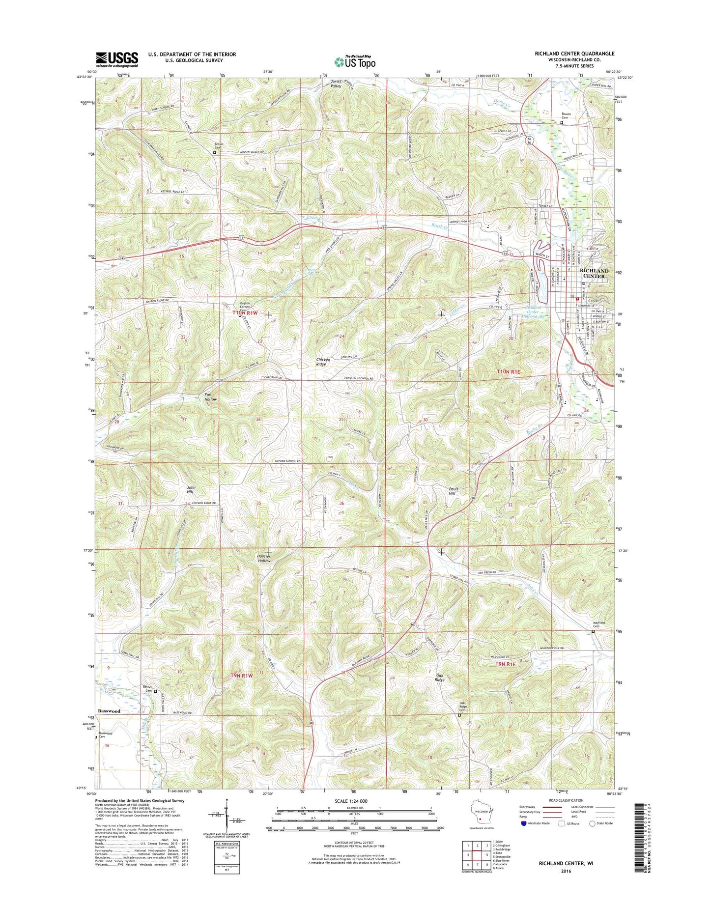
2018 topographic map quadrangle Richland Center in the state of Wisconsin. Scale: 1:24000. Based on the newly updated USGS 7.5' US Topo map series, this map is in the following counties: Richland. The map contains contour data, water features, and other items you are used to seeing on USGS maps, but also has updated roads and other features. This is the next generation of topographic maps. Printed on high-quality waterproof paper with UV fade-resistant inks.
Quads adjacent to this one:
West: Boaz
Northwest: Sabin
North: Gillingham
Northeast: Rockbridge
East: Sextonville
Southeast: Avoca
South: Muscoda
Southwest: Blue River
Contains the following named places: 1 Reservoir, 53581, Apostolic Faith Church, Ash Creek Farm, Ash Maple Farm, Ashford, Basswood, Basswood Cemetery, Bee Hive Farm, Berger School, Bethel Cemetery, Bethel School, Bethke Quarry, Bible Baptist Church, Bowen Cemetery, Breezy Hill Farm, Brewer Public Library, Brown Cemetery, Brush Creek, Brush Creek School, Castle Rock Farm, Center Creek, Chicken Ridge, Christ Gospel Church, Church of Christ in Christian Union, Church of the Nazarene, City of Richland Center, City Side Farm, City View Farm, Clearview Stock Farm, Colaton Stock Farm, Cold Spring Farm, Collins Dairy and Stock Farm, Cozy Nook Farm, Crow Hill School, Dayton Corners Cemetery, Dayton Corners Church, Doudna Elementary School, Eagle School, Elm Grove Place, Evergreen Place, First Assembly of God Church, First Baptist Church, Fox Hollow School, Free Methodist Church, Grand Orchard Fruit Farm, Grand View Holstein Farm, Homestead Farm, Hoosier Hollow School, Horse Creek, Huth School, Idlewild Farm, Jarvis Valley, Jefferson Elementary School, John Hill, John Hill Creek, Landencroft Farm, Lime Rock Hill Farm, Lincoln Elementary School, Lower Horse Creek School, Mapledale Farm, Mayfield Cemetery, Melvill Hall, Mill Creek 1b D-31.11 Dam, Miller Memorial Library, Oak Ridge, Oak Ridge Cemetery, Oak Ridge Holstein Farm, Oak View Farm, Oakland Farm, Oakview Stock Farm, Orchard Lawn Farm, Orchard Lawn Holstein Farm, Oxford School, Parfrey Dam, Park Street Christian Church, Pauls Hill, Pauls School, Peace United Methodist Church, Pier Spring, Pier Spring Creek, Pineglen Farm, Pleasant Hill Dairy Farm, Pleasant Valley Farm, Pleasant Valley Stock Farm, Richland Baptist Temple, Richland Center, Richland Center Cemetery, Richland Center Fire Department, Richland Center High School, Richland Center Millpond 189, Richland Center Police Department, Richland Center Post Office, Richland Center Wastewater Treatment Facility, Richland Christian Academy, Richland Community Building, Richland Country Club, Richland County Ambulance Service, Richland County Courthouse, Richland County Jail, Richland County Sheriff's Office, Richland Hospital, Richland Medical Center, Richland Middle School, Roadrunner Gymnasium, Rocky Branch, Rocky Branch School, Ruby Farm, Russells Stock Farm, Saint Barnabas Episcopal Church, Saint Johns Lutheran Church, Saint Lukes Lutheran Church, Saint Marys Catholic Church, Saint Marys School, School Number 4, Shady Nook Farm, Silvery Brook Dairy Farm, Sky View Farm, Spring Branch Farm, Spring Brook Farm, Story Field, Sunny Brook Stock Farm, Sunny Hill Farm, Sunny Side Stock Farm, Symons Recreation Complex, Tappes Homestead, Town and Country Presbyterian Church, Town of Dayton, Trinity United Methodist Church, Twin Springs Farm, University of Wisconsin Center-Richland, Valley Junction Stock Farm, Wallace Student Center, White Elm Farm, Willow Springs Farm, Woodside Farm, Woodside Stock and Sheep Farm, WRCO-AM (Richland Center), WRCO-FM (Richland Center)