MyTopo
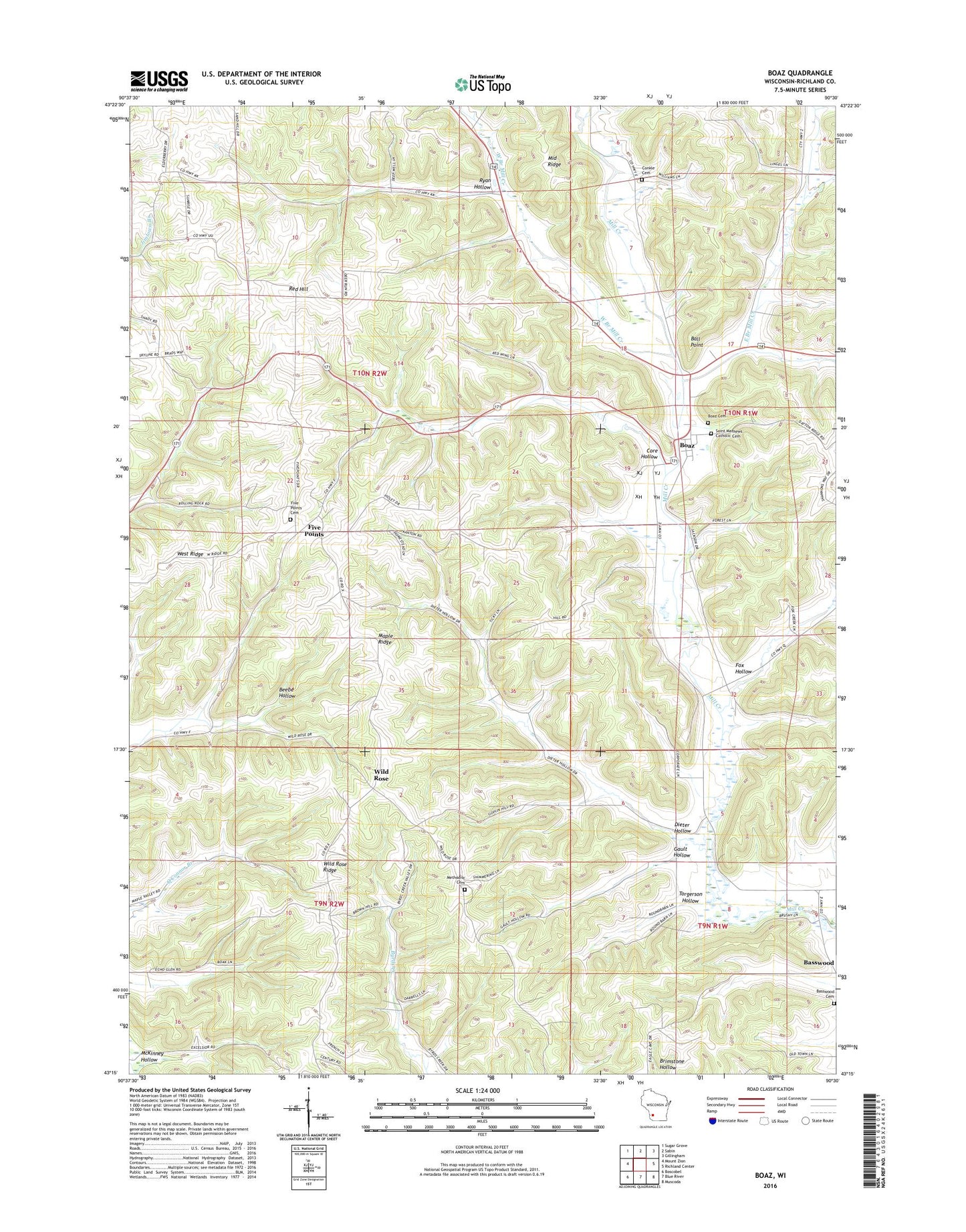
Boaz Wisconsin US Topo Map
Couldn't load pickup availability
2022 topographic map quadrangle Boaz in the state of Wisconsin. Scale: 1:24000. Based on the newly updated USGS 7.5' US Topo map series, this map is in the following counties: Richland. The map contains contour data, water features, and other items you are used to seeing on USGS maps, but also has updated roads and other features. This is the next generation of topographic maps. Printed on high-quality waterproof paper with UV fade-resistant inks.
Quads adjacent to this one:
West: Mount Zion
Northwest: Sugar Grove
North: Sabin
Northeast: Gillingham
East: Richland Center
Southeast: Muscoda
South: Blue River
Southwest: Boscobel
This map covers the same area as the classic USGS quad with code o43090c5.
Contains the following named places: 2 Reservoir, Akan Central Elementary School, Akan Township Quarry, Ball Point, Beaumont Homestead, Boaz, Boaz Cemetery, Conkle Cemetery, Conkle School, Core Hollow, Core Hollow School, Crystal Spring Farm, Dieter Hollow, Dieter Hollow Church, Dieter School, Eagle Valley Farm, East Branch Mill Creek, Echo Glen Stock Farm, Elm Tree Farm, Festina Farm, Five Points, Five Points Cemetery, Forest Home Farm, Fox Branch, Fox Hollow, Fox Hollow Church, Gault Hollow, Gault Hollow School, Glendale Farm, Hanson School, Hansons Homestead Stock and Grain Farm, Hardy Stock Farm, Harmony Church, Homestead Farm, Huleth Orchard Farm, Indian Hollow Farms, Johnson School, Larsons Homestead, Lyndale Farm, Maple Ridge, Maple Spring Stock and Grain Farm, Maple Valley Stock Farm, McKinney Hollow, Mill Creek 3 D-31.11 Dam, Mill Creek Farm, Mill Creek Valley Farm, Miller Branch, Neugarts Stock Dairy and Grain Farm, Nevels Corners, Oakwood Farm, Pleasant Hill Farm, Pleasant Ridge Church, Poplar Grove Farm, Red Hill, Red Hill Stock Dairy and Fruit Farm, Richland Church, Richwood Methodist Cemetery, Ridgewood Farm, Ridgewood Stock Dairy and Grain Farm, Rock View Farm, Round Barn Stock Farm, Ryan Hollow, Ryan School, Saint Martin Cemetery, Silver Leaf Farm, Silver Maple Dairy Farm, Spring Brook Farm, Springdale Stock and Dairy Farm, Sunny Ridge Farm, Torgerson Hollow, Torgerson School, Town of Akan, Valley Spring Farm, Village of Boaz, West Branch Mill Creek, West Branch School, West Ridge, Wild Rose, Wild Rose Ridge, Willow Corners Stock and Grain Farm, Willow Grove Farm, Willow Spring Stock and Dairy Farm