MyTopo
Sheboygan Falls Wisconsin US Topo Map
Couldn't load pickup availability
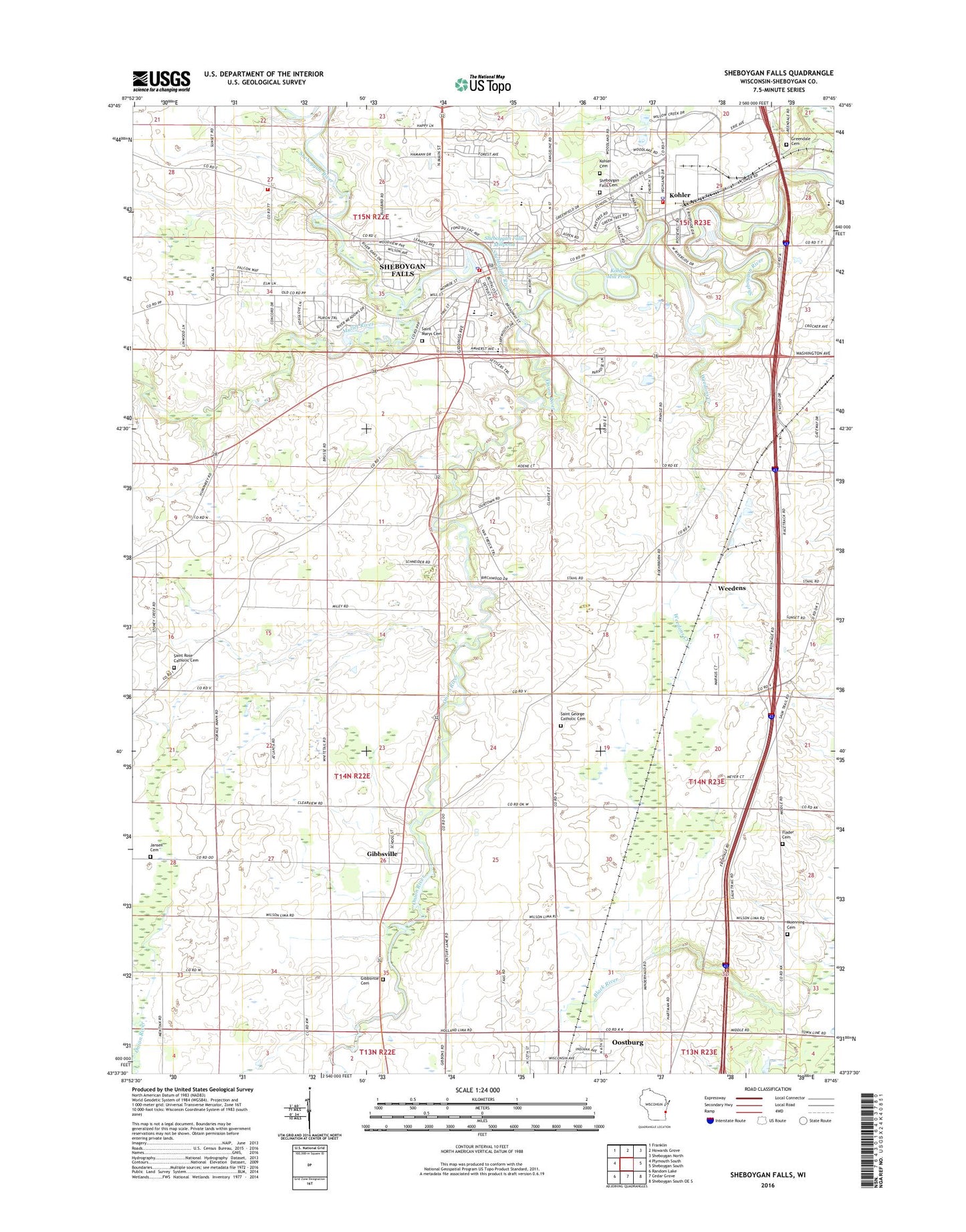
2018 topographic map quadrangle Sheboygan Falls in the state of Wisconsin. Scale: 1:24000. Based on the newly updated USGS 7.5' US Topo map series, this map is in the following counties: Sheboygan. The map contains contour data, water features, and other items you are used to seeing on USGS maps, but also has updated roads and other features. This is the next generation of topographic maps. Printed on high-quality waterproof paper with UV fade-resistant inks.
Quads adjacent to this one:
West: Plymouth South
Northwest: Franklin
North: Howards Grove
Northeast: Sheboygan North
East: Sheboygan South
Southeast: Sheboygan South OE S
South: Cedar Grove
Southwest: Random Lake
Contains the following named places: 85 Reservoir, Acacia Falls Mobile Home Court, Batting Memorial Library, Bethany Lutheran Church, Blessed Trinity Parish Cemetery, City of Sheboygan Falls, Cole Historic District, Dassow Milling Company Dam, Downtown Historic District, Faith United Methodist Church, Falls Community Church, First Baptist Church, First Pentecostal Church, First Reformed Church, Flader Cemetery, Gibbsville, Gibbsville Cemetery, Gibbsville Census Designated Place, Gibbsville Orchard, Grace United Church of Christ, Greendale Cemetery, Hilbes Airport, Hillcrest School, Jansen Cemetery, Kennedys Corners, Kohler, Kohler Cemetery, Kohler Elementary School, Kohler Fire Department, Kohler High School, Kohler Mill Pond, Kohler Police Department, Kohler Post Office, Landmark Christian Care Academy, Lightfoot Elementary School, Lima Center School, Madison School, Mann School, Moening Mueller Cemetery, Mullet River, Onion River, Orange Cross Ambulance, Ourtown, Richardson Dam, River Bend, River Park, Rochester Park, Saint George Catholic Cemetery, Saint George Church, Saint George Parish Rectory, Saint George School, Saint Johns Church, Saint Mary Catholic School, Saint Marys Catholic Church, Saint Mary's Cemetery, Saint Pauls Lutheran Church, Saint Peters Episcopal Church, Saint Rose Church, School Number Five, Sheboygan County Historical Research Center Library, Sheboygan Falls, Sheboygan Falls Cemetery, Sheboygan Falls City Hall, Sheboygan Falls Elementary School, Sheboygan Falls Fire Department, Sheboygan Falls High School, Sheboygan Falls Memorial Library, Sheboygan Falls Middle School, Sheboygan Falls Millpond 312, Sheboygan Falls Police Department, Sheboygan Falls Post Office, Sheboygan Lutheran High School, Sheboygan Speedway, Stoney Creek, Town of Lima, Town of Wilson, Trinity Lutheran Church, University of Wisconsin-Sheboygan County Campus, Village of Kohler, Waelderhaus, Weedens, Weedens School, Weedons Creek, WKTS-AM (Sheboygan), Word of Grace Community Church, ZIP Codes: 53044, 53085