MyTopo
Franklin Wisconsin US Topo Map
Couldn't load pickup availability
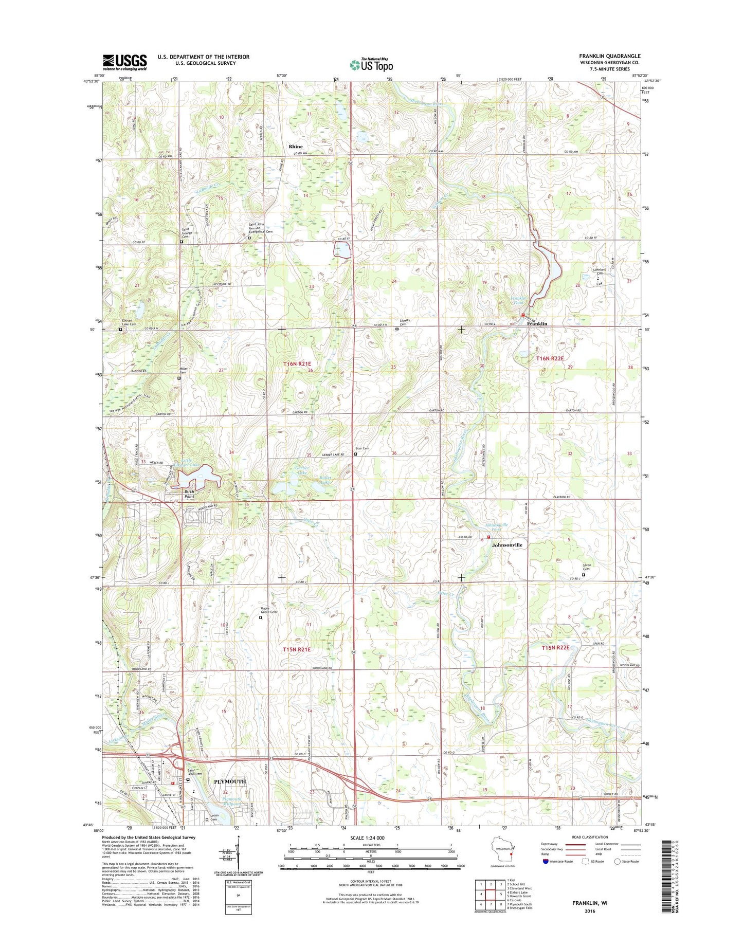
2022 topographic map quadrangle Franklin in the state of Wisconsin. Scale: 1:24000. Based on the newly updated USGS 7.5' US Topo map series, this map is in the following counties: Sheboygan. The map contains contour data, water features, and other items you are used to seeing on USGS maps, but also has updated roads and other features. This is the next generation of topographic maps. Printed on high-quality waterproof paper with UV fade-resistant inks.
Quads adjacent to this one:
West: Elkhart Lake
Northwest: Kiel
North: School Hill
Northeast: Cleveland West
East: Howards Grove
Southeast: Sheboygan Falls
South: Plymouth South
Southwest: Cascade
This map covers the same area as the classic USGS quad with code o43087g8.
Contains the following named places: A M Krueger Hall, Acorn School, Arnhoelter Dairy, Birch Point, Bradley Building, Bullet Lake, Camp Anokijig, Cen Mer Dairy Farm, Chase Center, Cleveland School, Doar Church, Dollar Lake, Elkhart Lake Cemetery, Esch Library, Fairview Elementary School, Faith Christian Academy, Feldmann Field, First Evangelical United Brethren Church, Franklin, Franklin Dam, Franklin Pond 170, Franklin School, Franklin Volunteer Fire Department, Friedli Hall, Gerber Lake, Grant School, Grether Natural Laboratory, Grosshuesch Hall, Hofer Hall, Immanuel United Church of Christ, Jackson Creek, Johnsonville, Johnsonville Fire Department, Johnsonville Pond, Lakeland College, Laun Center, Ley Chapel, Liberty Cemetery, Little Elkhart Lake, Little Elkhart Lake School, Maeuser Farm, Maple Grove Cemetery, Mill Pond, Miller Cemetery, Muelhmeier Hall, Nash Center, North Industrial Park, Old Main Hall, Otter Creek, Parkview Elementary School, Pinehurst School, Plymouth Millpond 58.6, Plymouth Volunteer Fire Department Station 2, Rhine, Rhine Boarder Farm, Rhine Center Bog State Natural Area, Rhinestone Farms, Riverview Middle School, Road America Raceway, Rocky Knoll Sanatorium, Romar Farms, Saint George Cemetery, Saint John Cemetery, Saint John Church, Saint Peter Evangelical Cemetery, Salem Evangelical and Reformed Church, Saron Cemetery, Saron Church, Schuett Creek, Sheboygan County Fairgrounds, Taylor Field, Town of Plymouth, Town of Rhine, Turner Hall, Union Cemetery, Victory School, Vorhulst Hall, W A Krueger Hall, Wehr Center, Zoar Salem Cemetery, ZIP Code: 53073