
MyTopo
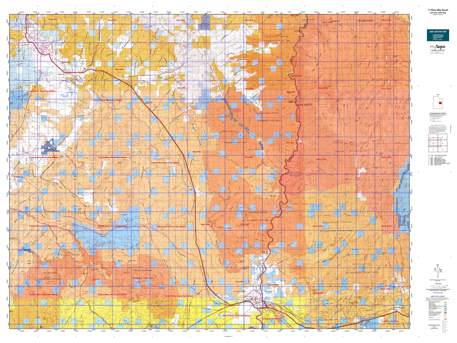
Utah Deer GMU 11 Nine Mile South Map
Couldn't load pickup availability
Hunting unit map of Utah Game Management Unit D-11-S with topographic lines and unit boundaries. This topo map features UTM / MGRS and Latitude/Longitude grids, plus public land ownership. It comes folded on waterproof paper. Be fully prepared for your hunt with a MyTopo GMU map!.
This map contains the following named places: 84501,84518,84520,84521,84525,84539,84542,Aldys Hole,Assembly Hall Peak,Battleship Butte,Bear Creek,Bear Trap Knoll,Big Hill,Big Hole,Big Hole Pond,Big Hole Wash,Big Horn Benches,Big Horn Mountain,Big Spring Ranch,Black Hills,Blue Castle,Blue Castle Butte,Blue Pond,Blue Slate Hills,Bluebell Creek,Bob Hill Knoll,Bottleneck Peak,Boulder Mesa,Browns Wash,Buckhorn Corral,Buckhorn Reservoir,Buffalo Bench,Bull Hollow Corral,C C C Pond,Calf Mesa,Camp Vinero,Carbonville,Castle Dale-Huntington Division,Cat Pond,Cedar,Cedar Mountain,Cedar Mountain Campground,Cedar Mountain Knoll,Cedar Mountain Recreation Area,Chalk Hills,Chandler Point,Chicken Fork,Chimney Rock,Chimney Rock Flat,City of East Carbon,City of East Carbon-Sunnyside,City of Green River,City of Price,City of Sunnyside,City of Wellington,Clark Valley,Cleveland,Cleveland Lloyd Dinosaur Quarry,Cleveland-Lloyd Dinosaur Quarry Campground,Cloyds Pond,Coal Canyon Bench,Coal Creek,Columbia,Columbia Junction,Cottonwood Creek,Cow Flat Reservoir,Crescent Butte,Crescent Wash Reservoir,Cub Valley,Daly,Deadman Creek,Desert,Desert Lake,Desert Lake Waterfowl Management Area,Devils Hole,Dog Ponds,Dragerton,Drought Relief Reservoir,Drowned Hole,Dry Fork,Dry Mesa,Dry Pond,Dugout Creek,Dugway Reservoir,East Carbon City,El Rancho Motel and RV Campground,Elgin,Elliott Mesa,Elmo,Emery County,Favorite Hills,Ferron Creek,Flat Top,Flattop Mountain,Florence Creek,Fox Point,Gaylord Siding,Goodwater Reservoir,Gordon Creek,Grassy,Grassy Trail Creek,Green River,Green River Campground,Green River State Recreation Area,Gunnison Butte,Gunnison Valley,Guymon Pond,Hadden Hills,Hadden Pit,Hadden Reservoir,Harris Fork,Hill Creek Ranger Station,Hill Creek Youth Camp,Hillview RV Park Campground,Horse Canyon,Horse Creek,Horse Heaven,Horse Mesa,Huntington Creek,Icelander Creek,J J Reservoir,Jacks Rock,Jim Wilson Reservoir,Job Corps Pond,Joe Hole Wash,Joe Hutch Creek,Joes Holes,Johansen Pond,Jorgensen Pond,Kiahtipes Reservoir,Left Fork Rock Creek,Lews Hole,Little Blue Pond,Little Cedar Mountain,Little Elliott Mesa,Little Holes,Lynns Pond,Mamies Garden,McPherson Ranch,Merrials Pond,Mexican Mountain,Middle Mountain,Midway Reservoir,Miller Creek,Moonshine Waterhole,Moonwater Point,Mounds,Mounds Reservoir,Mount Elliott,No Mans Land Point,No Mans Mountain,North Point,Nutters Hole,Old Ramage Pond,Olsen Reservoir,Orsons Pond,Pace Creek,Patmos Head,Petes Hole,Pierson Ranch,Pilling Pond,Pilling Ranch,Pinnacle Mesa,Pinnacle Peak,Pinnacle Wash,Post Canyon Point,Price,Price Division,Price Game Farm,Price River,Range Creek,Range Valley Mountain,Red Knoll,Red Point,Rock Creek,Rock Creek Ranch,Russel Pond,Saleratus Reservoir,San Rafael Bridge Campground,Sand Pond,Serviceberry Creek,Sids Mountain,Sids Reservoir,Silvagni Ranch,Slough Canyon Point,Smith Cabin,Smith Pond,Soldier Creek,South Reservoir,Southeast Mounds Reservoir,Sphinx,Spider Reservoir,Stevens Cabin,Sugarloaf,Suluar Mesa,Summerville Point,Summit Pond,Sunnydale,Sunnyside,Sunnyside Junction,Sunrise Dugway,Swazy Hole,The Basin,The Nipple,The Peaks,The Rocks,The Wedge Overlook,Three Coves Reservoir,Three Golden Stairs,Tom Farrer Valley,Town of Cleveland,Town of Elmo,Tusher Wash,Twin Peaks,U S Steel Corp Storage Reservoir,Uintah and Ouray Division,Upper Sunnyside,Verde,Victor,Walker Point,Wedge Overlook,Wedge Pond Number 1,Wedge Pond Number 2,Wedge Pond Number 4,Wellington,West Fork Hill Creek,West Point,Wilcox Ranch,Wild Horse Basin,Willow Spring Cow Camp,Wimmer Knoll,Window Blind Peak,Wood Hill,Woodside,Xmas Mountain


