MyTopo
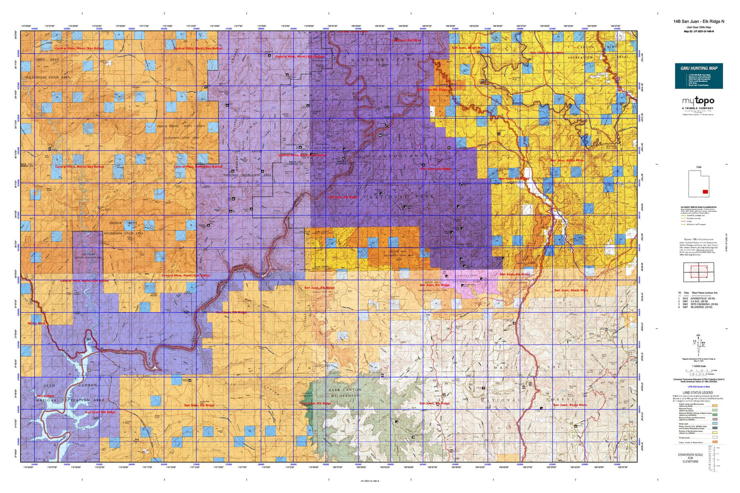
Utah Deer GMU 14B San Juan - Elk Ridge N Map
Couldn't load pickup availability
Hunting unit map of Utah Game Management Unit D-14B-N with topographic lines and unit boundaries. This topo map features UTM / MGRS and Latitude/Longitude grids, plus public land ownership. It comes folded on waterproof paper. Be fully prepared for your hunt with a MyTopo GMU map!.
This map contains the following named places: Avalanche Mine,Bagpipe Butte,Bagpipe Butte Overlook,Bayles Cabin,Bayles Ranch,Beef Basin,Beef Basin Wash,Bert Mesa,Best Inscription-1891,Betty Mine,Big Drop Rapids,Big Pocket,Big Spring Canyon Overlook,Big Water Canyon,Black Bean Mine,Black Jump,Black Ledge,Black Point,Black Steer Point,Blue Creek,Blue Creek Cabin,Blue Creek Point,Blue Creek Reservoir,Bobbys Hole,Bogus Pocket,Boundary Butte,Bowdie Canyon,Bowdie Point,Bridger Jack,Bridger Jack Mesa,Bridger Jack Mesa Outstanding Natural Area,Bright Angel Trail,Brimhall Point,Brown Betty Rapids,Browns Bottom,Browns Rim,Buckacre Point,Bull Canyon,Bull Valley,Burr Point,Butler Wash,Calamity Mesa,Calf Canyon,Canyonlands National Park,Canyonlands Resort,Cataract Canyon,Cathedral Butte,Cathedral Point,Cave Cliff,Cave Spring Trail,Cedar Mesa,Cedar Point,Chesler Canyon,Chimney Rock,Chippean Ridge,Chippean Rocks,Chocolate Drops,Clearwater Canyon,Colorado River Overlook,Confluence Overlook,Cooper Reservoir,Copper Point,Corral Pocket,Cove Canyon,Cow Canyon,Cross Canyon,Cyclone Canyon,D Julien Inscription-1836,Dandy Crossing,Dark Canyon Plateau,Dark Canyon Primitive Area,Dark Canyon Rapids,Davis Canyon,Davis Pocket,Deadman Point,Devils Lane,Devils Pocket,Dirty Devil River,Dry Basin,Dry Mesa,Duck Lake,Duck Lake Point of Interest,Dugout Dam,Dugout Ranch,Dugout Reservoir,East Fork Salt Creek,East Fork Twin Canyon,Eddy Inscription-1927,Elaterite Basin,Elaterite Butte,Elephant Canyon,Elephant Hill,Ernies Country,Farley Canyon,Fault Point,Fiddler Butte,Fiddler Cove,Fiddler Cove Canyon,Flint Cove,Flint Trail,Flint Trail Overlook,Freddies Cistern,French Spring Fork,Gibex Point,Gilex,Glencove,Gooseberry Ranger Station,Grainery Rock,Green River,Gunsight Butte,Gypsum Canyon,Hans Flats Ranger Station,Happy Canyon,Harts Point,Hatch Canyon,Hite,Hite Crossing,Hite Marina,Hite Marina Campground,Hop Creek,Horse Canyon,Horse Mountain,House Park Butte,Imperial Valley,Joint Trail,Kirk Cabin,Kirk Fence,Kolb Inscription-1911,Lake Powell Overlook,Land of Standing Rocks,Lands End,Lavender Creek,Lavender Point,Lean-To Point,Lens Canyon,Little Dry Mesa,Lizard Rock,Lost Canyon Point,Lower Jump,Lower Red Lake Canyon,Maverick Point,Maverick Point Overlook,Maverick Visitor Information Site,Maze Overlook,Middle Point,Mile Long Rapids,Mille Crag Bend,Mormon Pasture Mountain,Mormon Pasture Point,Natural Arch Point of Interest,Needles Outpost Campground,Nevills Inscription,North Block,North Cottonwood Creek,North Cottonwood Guard Station,North Elk Ridge,North Long Point,North Point,North Sixshooter Peak,North Trail,North Wash,Observation Rock,Ocean Point,Pappys Pasture,Petes Mesa,Plateau Region,Pothole Point,Red Benches,Red Cove,Red Monument,Red Point,Reef of Rocks,Rim View,Round Mountain,S.O.B. Hill,Salt Creek,Salt Creek Mesa,Salt Creek Pocket,Sams Mesa,Seven Sisters Buttes,Silver Stairs,Sin-av-to-weap,Skull and Crossbones Point of Interest,Skull and Crossbones Summit,South Block,South Sixshooter Peak,Spanish Bottom,Squaw and Papoose Rock,Squaw Butte,Squaw Flat Campground,Squaw Trail,Standing Rock,Starvation Point,Sweet Alice Canyon,Sweet Alice Hills,Tapestry Slab,Tar Cliff,Teapot Canyon,Teapot Rock,The Big Ridge,The Block,The Button,The Causeway,The Confluence,The Cove,The Doll House,The Fins,The Golden Stairs,The Grabens,The Hat,The Island,The Loop,The Maze,The Mother and Child,The Needles,The Needles Country,The Needles Ranger Station,The Pinnacle,The Pinnacles,The Plug,The Sewing Machine,The Wall,The Wilderness,Thirteen Faces,Trachyte Creek,Trachyte Point,Twin Valleys,Upper Jump,Vega Creek,West Fork Lavender Creek,West Fork Salt Creek,White Canyon,White Canyon Creek,Wild Cow Point,Wilson Ranch