MyTopo
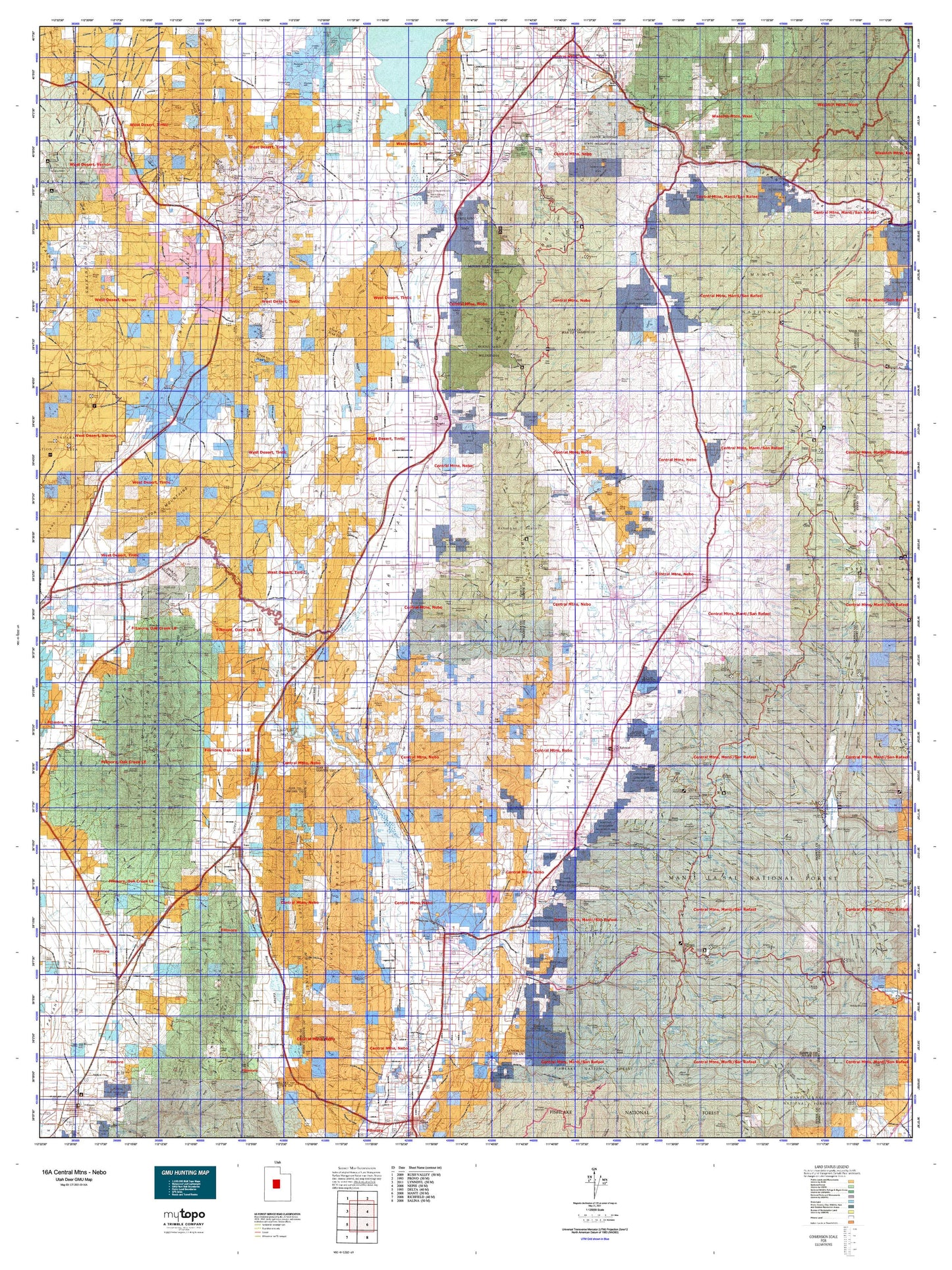
Utah Deer GMU 16A Central Mtns - Nebo Map
Couldn't load pickup availability
Hunting unit map of Utah Game Management Unit D-16A with topographic lines and unit boundaries. This topo map features UTM / MGRS and Latitude/Longitude grids, plus public land ownership. It comes folded on waterproof paper. Be fully prepared for your hunt with a MyTopo GMU map!.
This map contains the following named places: Andys Pond,Axtell,Bald Mountain,Beaver Dams Summer Homes Area,Benjamin,Big Baldy,Big Hill,Big Mountain,Billies Mountain,Birch Spring Point,Birdseye,Bismark Peak,Black Hawk,Black Hill,Black Knob,Black Mountain,Block Mountain,Blue Mountain,Bone Yard,Boulter Peak,Boulter Summit,Browns Peak,Buck Peak,Buckhorn Mountain,Burnt Hill,Castilla,Cedar Hill,Cedar Hills,Cedar Knoll,Cedar Knolls,Cedar Mountain,Centerfield,Chalk Hill,Champlin Peak,Chester,Christianburg,Coffee Peak,Cove Mountain,Covered Bridge Canyon,Cox Knoll,Dairy Knoll,Dairy Point,Danish Knoll,Davis Hill,Dennis,Devils Peak,Diamond,Dividend,Dominguez Hill,Dry Mountain,Dusterburgs Hill,Elk Ridge,Elks Knoll,Ephraim,Eureka,Eureka Peak,Fairview,Fayette,Ferron Mountain,Flagstaff Peak,Fool Creek Peak,Fountain Green,Freedom,Gal Hill,Genola,Godiva Mountain,Gomex,Goshen,Goshen Hill,Guard Knoll,Gunnison,Gypsum Mill,Hannifin Peak,Harmonica Point,Harris Knoll,Haystack Hill,Haystack Mountain,Heliotrope Mountain,Heliotrope Point,High Peak,High Top,Hill Top,Hillside,Holden,Homansville,Horse Heaven Mountain,Horse Mountain,Horseshoe Hill,Horseshoe Mountain,Indian Knoll,Indianola,Jericho,Jerusalem,John Jones Hill,Josephite Point,Juab,Keigley,Knight,Knightville,Knob Mountain,Lake Mountain,Lant,Leamington,Leland,Levan,Levan Peak,Lewis,Lime Peak,Little Hill,Little Mountain,Little Nelson Mountain,Little Red Hill,Loafer Mountain,Long Knoll,Long Point,Low Hills,Lowry Top,Mahogany Hill,Mammoth,Mammoth Junction,Mammoth Peak,Manti,Manti Canyon Summer Homes,Manti Mountain,Marble Hill,Marys Nipple,Mayfield,McIntyre,Middle Mountain,Milburn,Mill Fork,Mill Hill,Mills,Mineral Hill,Moark Junction,Mollies Nipple,Mona,Moroni,Moroni Hill,Mount Baldy,Mount Nebo,Mount Pleasant,Nelson Mountain,Nephi,Nielson Knoll,Noon Rock Peak,North Hill,North Peak,North Tent Mountain,Oak Creek,Old Baldy,Order Mountain,Packard Peak,Parley,Partridge Mountain,Patrick Place,Payson,Petty Peak,Pigeon Hollow Junction,Pine Crown Peak,Pines,Pinyon Peak,Pollys Peak,Porcupine Knoll,Rattlesnake Peak,Red Point,Reynold Point,Rio,River Knoll,Rocky Point,Rocky Ridge,Round Hill,Round Hills,Round Knoll,Salem,Salt Creek Peak,Santaquin,Santaquin Peak,Scipio,Sharp,Sheepherder Hill,Silver City,Sioux Peak,Skinner Peaks,Sky High,Slick Hill,Soma,South Apex Hill,South Hills,South Mountain,South Tent Mountain,Spanish Fork Peak,Spearmint,Spring City,Spring Hill,Spring Lake,Starr,Steamboat Point,Sterling,Sugarloaf,Sunrise Peak,Sutro,Swedish Knoll,Teat Mountain,Temple Hill,Tenmile Hill,The Buckskin,The Summit,Thistle,Three Forks,Three Knolls,Tintic Junction,Tintic Mountain,Tithing Mountain,Towhead,Townsend,Trail Mountain,Treasure Hill,Twin Knolls,Uisco,Wales,Wanlass Hill,Warm Springs Mountain,West Ephraim,West Hills,West Mountain,White Hill,White Knoll,Wild Horse Peak,Williams Peak,Windy Point,Witches Knoll,Woodland Hills,Woodtick Point,Wrigley Hill