MyTopo
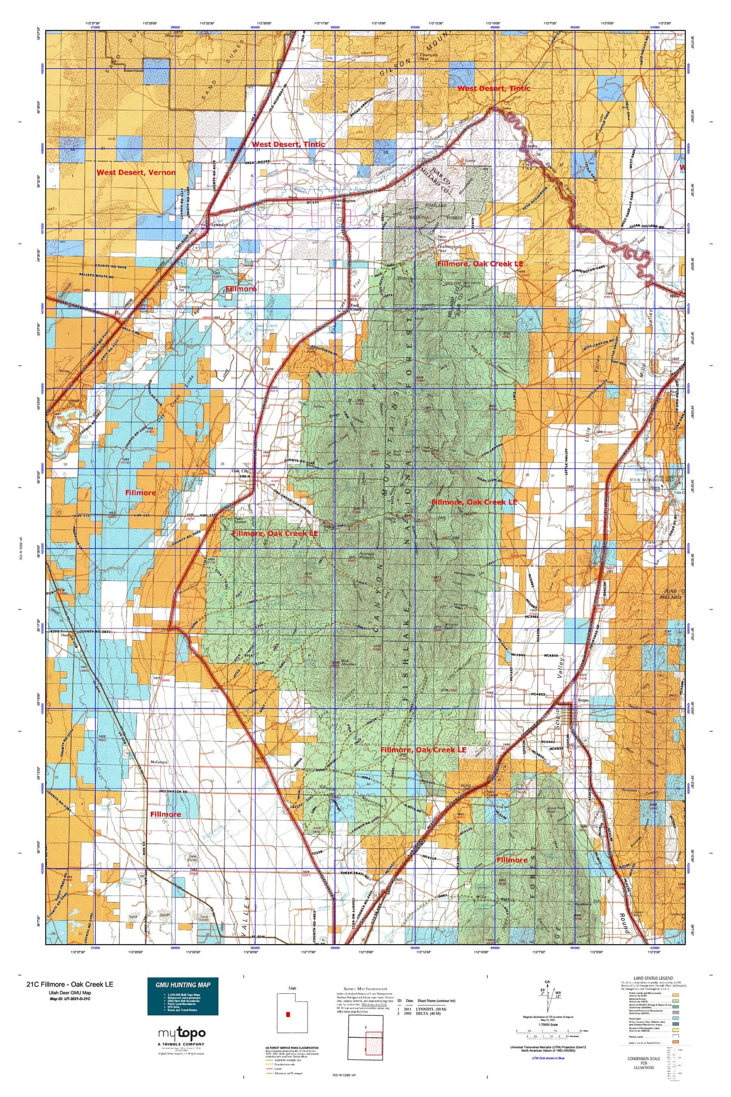
Utah Deer GMU 21C Fillmore - Oak Creek LE Map
Couldn't load pickup availability
Hunting unit map of Utah Game Management Unit D-21C with topographic lines and unit boundaries. This topo map features UTM / MGRS and Latitude/Longitude grids, plus public land ownership. It comes folded on waterproof paper. Be fully prepared for your hunt with a MyTopo GMU map!.
This map contains the following named places: 84638,84640,84649,Antelope Spring,Arrowhead Mine,Basin Canyon,Basin Hollow,Bear Hollow,Big Gully,Big Hollow,Big Spring,Black Willow Spring,Blue Mountain,Blue Springs,Bowens Canyon,Box Canyon,Bridge Canyon,Broad Canyon,Buck Hollow,Buck Peak,Canyon Mountains,Cascade Creek,Cascade Spring,Cedar Ridge Spring,Central Utah Canal,Charley Johnson Canyon,Church Mountains,Church Spring,Clay Spring Wash,Cold Spring,Cow Canyon,Cow Canyon Spring,Coyote Spring,Crooked Canyon,Davison Canyon,Devil Canyon,Devils Canyon,Devils Den,Devils Twist,Dog Valley Wash,Dry Creek,Dry Fork,Duggins Creek,East Fork Eightmile Creek,Eightmile Canyon,Enoch Point,First Spring,Fishers Spring,Flat Canyon,Fool Creek,Fool Creek Flat,Fool Creek Number One Dam,Fool Creek Number Two Dam,Fool Creek Number Two Reservoir,Fool Creek Peak,Fool Creek Point,Fool Creek Reservoir Number 1,Gilson Wash,Graball Canyon,Hardscrabble Canyon,Hatch Cabin,Horse Hollow,Jack Hill,Jakes Canyon,Jim Wills Canyon,John Williams Canyon,Klondike Canyon,Knoll Hollow,Leamington,Leamington Canal,Leamington Canyon,Leamington Cemetery,Leamington Pass,Leamington Volunteer Fire Department,Limekiln Canyon,Little Creek,Little Creek Campground,Little Long Canyon,Little Oak Canyon,Little Oak Creek,Little Pole Canyon,Little Sage Valley,Little Valley,Little Wild Horse Canyon,Long Canyon,Long Knoll,Lovell Hollow,Low Hills,Lower Clay Spring,Lyman Canyon,Lynndyl,Lynndyl Cemetery,Lynndyl Fire Department,Lynndyl Post Office,Mack,Macks Ditch,Mahogany Hollow,Maple Spring,Mayparty Spring,McCornick,McCornick Cemetery,McIntyre Canal,Middle Canyon,Mill Canyon,Mills Cemetery,Mine Hollow,Molten Spring,Mourning Dove Spring,Mud Spring,Murrays Canyon,Netties Canyon,Noon Rock Canyon,Noon Rock Peak,North Walker Canyon,Oak City,Oak City Cemetery,Oak City Fire Department,Oak City Post Office,Oak Creek,Oak Creek Campground,Oak Creek Ranger Station,Oak Creek Sinks,Ox Hollow,Pahvant Valley,Parley,Partridge Mountain,Partridge Mountain Research Natural Area,Pass Canyon,Pauls Meadow,Peak Canyon,Pipe Spring,Platnation Flat Campground,Pole Canyon,Prouse Canyon,Quaking Asp Hollow,Quaking Asp Spring,Quarry Spring,Radford Canyon,Rattlesnake Canyon,Rocky Ridge Canyon,Roger Hollow,Rogers Canyon,Rough Hollow,Round Valley Creek,Sage Valley,Sawmill Canyon,Scipio,Scipio Ambulance Service,Scipio Cemetery,Scipio Fire Department,Scipio Pass,Scipio Pioneer Cemetery,Scipio Valley,Sevier Canyon,Sixmile Point,Sixmile Wash,Snage Canyon,Soma,Sorensen Canyon,South Walker Canyon,Spring Canyon,Talbot Family Cemetery,Tank Canyon,Tanner Creek,Taylors Flat,The Church of Jesus Christ of Latter Day Saints,The Gap,The Knoll,The Narrows,Town of Leamington,Town of Lynndyl,Town of Oak City,Town of Scipio,Uisco,Upper Clay Spring,Upper Ebbs Spring,Upper Narrows Spring,Upper Quaking Asp Canyon,Watercrest Spring,Weetches Canyon,West Fork Eightmile Creek,West Fork Reservoir,Whisky Creek,Whisky Spring,Wide Canyon,Wide Canyon Spring,Wild Horse Canyon,Wild Horse Peak,Wildhorse Spring,Williams Peak,Wood Canyon,Wringer Canyon,Yance Canyon