
MyTopo
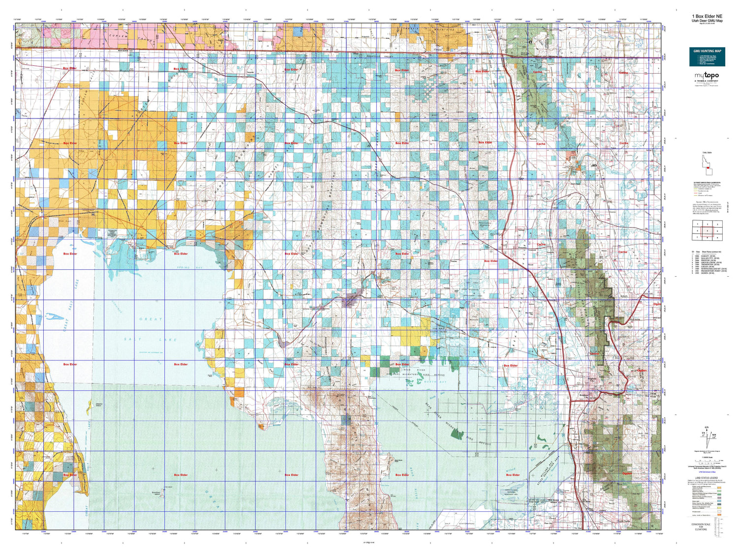
Utah Deer GMU 1 Box Elder NE Map
Couldn't load pickup availability
Hunting unit map of Utah Game Management Unit D-NE with topographic lines and unit boundaries. This topo map features UTM / MGRS and Latitude/Longitude grids, plus public land ownership. It comes folded on waterproof paper. Be fully prepared for your hunt with a MyTopo GMU map!.
This map contains the following named places: 84301,84302,84305,84306,84307,84309,84311,84312,84314,84316,84330,84331,Anderson Hill,Baker Slough,Bar F Ranch,Bar M Slough,Bear River,Bear River City,Bear River Migratory Bird Refuge,Bear River National Migratory Bird Refuge,Beaver Dam,Birch Creek,Black Mountain,Black Slough,Blue Creek,Blue Creek Reservoir,Boothe Valley Hill,Bothwell,Box Elder County,Box Elder Creek,Box Elder Peak,Bradford,Brigham City,Brigham City Country Club,Brigham City Division,Brigham City Shopping Center,Brigham Young Park,Broom Mountain,Bush,Calls Fort Monument,Cedar Hill,Cedar Springs,Cement Ponds,Chesapeake Duck Club,Chocolate Peak,City Creek,City of Bear River City,City of Brigham City,City of Corinne,City of Garland,City of Honeyville,City of Perry,City of Tremonton,City of Willard,Clarkston,Clarkston Creek,Clarkston Mountain,Cold Spring Lakes,Cold Springs Creek,Collinston,Corinne,Cottonwood Creek,Coyote Ponds,Crocker Lake,Crocker Marsh,Crocodile Mountain,Cropley,Crossroads,Crystal Spring Resort,Crystal Springs,Cub Island,Curlew Junction,Dead River,Deadman Knoll,Deep Creek,Deweyville,Dike Lake,Division Lake,Dix Creek,Dolphin Island,Doutres Mobile Home Park,Duck Lake,Duckville Gun Club,Duffy Creek,East Crocker Lake,East Lake,East Promontory,Elwood,Engineer Mountain,Evans,Facer Creek,Fielding,Fielding Siding,First Salt Creek,Ford,Franklin Hill,Garland,Glory Hole,Golden Spike Monument,Golden Spike National Historic Site,Goose Island,Gunnison Bay,Gunnison Island,Gunnison Island State Wildlife Management Area,Gunsight Peak,Hansel Valley Wash,Hansen Lake,Harold S Crane Waterfowl Management Area,Historical Monument Stage Station,Honeyville,Horseshoe Sloughs,Howell,Howell-Snowville Division,Hull Lake,Indian Creek,Indian Hill,Jesses Knoll,Johnson Hill,Junction Hills,Kelton,Klondike Lake,Lampo Junction,Landmark Letters Branch,Lemon Peak,Limekiln Knoll,Little Mountain,Locomotive Springs Waterfowl Management Area,Madsen,Malad River,Mallard Pond,Mendon Peak,Messix Peak,Mill Run,Monument Peak,Mount Tarpey,Mouth of Bear River,Mud Lake,Mueller Lake,Mushback Point,Myler Creek,Myler Grove,Nerva,North Bay,North Lake,North Pond,North Recreation Area,Northwestern Shoshone Reservation,Off Slough,Ogden Gun Club,Old Stage Station,Penrose,Perry,Perry Basin,Perry Siding,Peterson Pond,Pilot Springs Stage Station,Pintail Gun Club,Pintail Lake,Pintail Marsh,Pintail Neck,Pipeline Point,Plymouth,Point Lookout Mountains,Portage,Promontory,Public Shooting Grounds Waterfowl Management Area,Reeder Overflow,Rees Park,Riverside,Rock Island,Rose Ranch,Rose Ranch Reservoir,Round Knoll,Rozel,Rozel Hills,Rozel Point,RV Acres Campground,Salt Creek,Salt Creek Waterfowl Management Area,Scout Peak,Second Salt Creek,Skating Pond,Snowville,South Bay,South East Bay,South Pond,South Recreation Area,South Willard,Sparks Slough,Spires Lake,Spring Lake,Sulphur Creek,Surbon,Teal Slough,Tenmile Creek,Thatcher,Thatcher Mountain,The Horseshoe,The Knoll,Threemile Creek,Town of Clarkston,Town of Deweyville,Town of Elwood,Town of Fielding,Town of Howell,Town of Plymouth,Town of Portage,Town of Snowville,Tremonton,Tremonton Division,Utah Hot Springs,Warm Springs Creek,Washakie,Wellsville Cone,Wellsville Mountain Wilderness,West Crocker Lake,West Lake,West Locomotive Slough,West Marsh,Wheelon,White Rock,Widgeon Lake,Widgeon Marsh,Wildcat Hills,Willard,Willard Bay North Marina Campground,Willard Bay Reservoir,Willard Bay South Marina Campground,Willard Bay State Park,Willard Bay Upland Game Management Area,Willard Creek,Willard Pumping Station Number 1,Willow Creek,Woods Creek,Youngs Corral


