MyTopo
Utah Elk GMU Book Cliffs Map
Couldn't load pickup availability
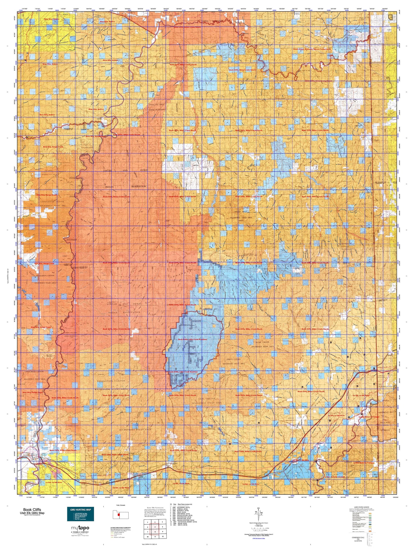
Hunting unit map of Utah Game Management Unit ELK-BookCliffs with topographic lines and unit boundaries. This topo map features UTM / MGRS and Latitude/Longitude grids, plus public land ownership. It comes folded on waterproof paper. Be fully prepared for your hunt with a MyTopo GMU map!.
This map contains the following named places: 84063,84525,84540,Agate,Antelope Knolls,Archy Bench,Bar X Gas Field,Bates Knolls,Bear Trap Knoll,Beaver Hole,Beaver Slide Bottom,Benion Bench,Big Hole,Big Pack Mountain,Big Park,Billeys Reservoir,Bitter Creek,Bitter Creek Corral,Black Knolls,Blue Knoll,Blue Stem,Bluebell Creek,Boat Bottom,Bonanza,Book Cliffs Natural Area,Boulder Mesa,Bread Knolls,Brown Corral,Butte Reservoir,Castle Peak,Castle Peak Mine,Cave House,Cedar Corral,Cedar Knolls,Chandler Point,Cherry Mesa,Chicken Fork,Chimney Rock,Cisco Mesa,Clear Creek,Coal Canyon Bench,Coal Creek,Coal Creek Bench,Coleman Reservoir,Corral Canyon Bench,Corral Canyon Point,Corral Creek,Corral Point,Cottonwood,Cottonwood Point,Crescent Butte,Crescent Mine,Crescent Wash Reservoir,Crow Knoll,Cub Valley,Cunningham Ranch,Daly,Dead Sheep Pond,Desolation Canyon Historical Landmark,Dog Knoll,Dragon,Dry Fork,Duches Hole,East Bench,East Fork Bitter Creek,East Fork Little Creek,East Willow Creek,Evacuation Creek,Fairbanks Crossing,Firewater Point,Fish Creek,Flat Rock Mesa,Florence Creek,Flu Knoll Reservoir,Flu Knolls,Fourmile Bottom,Fox Point,Gold Hole,Grand County,Gray Knoll,Gray Knolls,Harley Dome,Harris Fork,Hat Rock,Hatch Reservoir,Hatchs Camp,Hells Hole,Hill Creek,Hill Creek Point,Hill Creek Ranger Station,Hill Creek Youth Camp,Holding Pond,Horner Knoll,Horse Bench,Horse Mesa,Horse Point,Hydes Bottom,Ignatio Stage Stop,Jack Creek,Jacks Hole,Jacks Rock,Joe Hutch Creek,Jumping Off Point,Kilroy Reservoir,Kings Canyon Bottom,Last Chance Benches,Left Fork Rock Creek,Left Hand Fish Creek,Lion Bench,Little Bonanza,Little Creek,Little Dicks Bottom,Little Dolores River,Little Hole,Little Horse Bottom,Little Pack Mountain,Little Whiskey Creek,Long Bottom,Maverick Bottom,Mayos Cabin,McPherson Ranch,Meadow Creek,Mexico Point,Middle Fork Bitter Creek,Missouri Creek,Mollys Nipple,Moon Bottom,Moonwater Point,Naval Oil Shale Reserve Number Two,Nine Hole,Nine Mile Creek,No Mans Land Point,North Point,Nutters Hole,Nutters Rock,Olsen Corral,Pariette East Dike Reservoir,Pariette Flood Control Reservoir,Pariette Waterfowl Habitat Management Area,Peters Point,Pinnacle Mesa,Pioche Creek,Post Canyon Point,Potato Creek,Potato Hill,Poverty Bench,Price River,Rainbow,Ranch Bottom,Range Creek,Rays Bottom,Red Point,Right Hand Fish Creek,Roan Peaks,Robidoux Compressor Station,Robidoux Inscription,Rock Creek,Rock Creek Ranch,Rock House Bottom,Rock Spring Mesa,San Arroyo Camp,Sand Wash River Ranger Station and Put In Site,Santio Crossing,Santio Knolls,Seely Cabin,Sego,Sheep Knolls,Sheep Reservoir,Slough Canyon Point,Slough Grass,Snider Bottom,Snyder Mesa,Snyder Reservoir,Split Point,Spring Creek,Squaw Crossing,Stevens Cabin,Stevens Ranch,Strychnine Pond,Sulphur Creek,Suluar Mesa,Sumner Amphitheater,Sunday School Reservoir,Sunrise Dugway,Sunset Dugway,Survey Point,Surveyors Hole,Swedes Hole,Tabyago Basin,Taylor Point,Tenmile Knoll,Tepee Point,The Basin,The Grassies,The Pines,Thimble Rock,Thompson Springs Division,Three Fords Benches,Three Golden Stairs,Three Pines,Tia Juana Bottom,Tie Pond,Tom Farrer Valley,Tom Patterson Point,Tomlinson Ranch,Towave Reservoir,Twin Knolls,Twin Pond,Uintah and Ouray Division,Utaline,Uteland Mine,Walker Point,Walsh Knolls,Watson,Weaver Reservoir,West Fork Bitter Creek,West Fork Hill Creek,West Point,West Willow Creek,Westwater,Westwater Creek,Westwater Point,Westwater River Ranger Station and Put In Site,White Face Butte,White River,Wilcox Point,Wild Horse Basin,Wild Horse Bench,Willow Creek,Windy Mesa,Windy Point,Wire Fence Point,Wolf Den,Wolf Point,Xmas Mountain