
MyTopo
Utah Elk GMU Chalk Creek Map
Couldn't load pickup availability
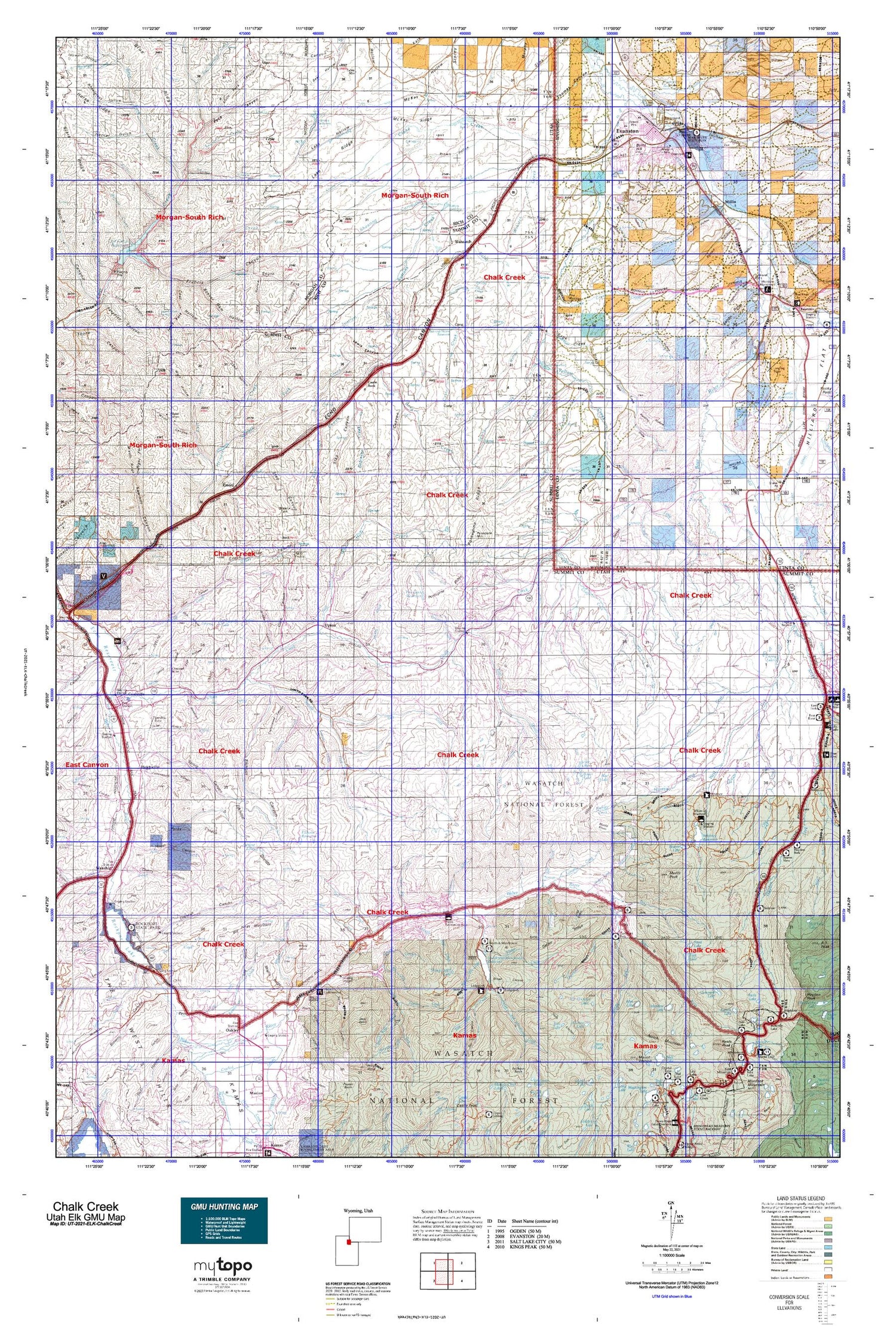
Hunting unit map of Utah Game Management Unit ELK-ChalkCreek with topographic lines and unit boundaries. This topo map features UTM / MGRS and Latitude/Longitude grids, plus public land ownership. It comes folded on waterproof paper. Be fully prepared for your hunt with a MyTopo GMU map!.
This map contains the following named places: 84017,84055,84061,Aagard Ranch,Abes Lake,Adax Lake,Anchor Lake,Area A Recreation Site,Area B Recreation Site,Area C Recreation Site,Aspen Creek,Aspen Grove Campground,Ball and Moore Reservoir,Barker Reservoir,Basin Creek,Bear Basin,Bear River Mall,Bear Trap Creek,Beaver Lake,Beaver Meadow Reservoir,Belnap Creek,Bench Lake,Bessie Bottom,Big Piney Mountain,Big Robinson Ditch,Blue Fork Creek,Blue Lake,Bob Young Creek,Bonnie Lake,Boulderville Ditch,Bourbon Lake,Boyer Lake,Branch Creek,Brown Creek,Bud Lake,Bull Creek,Bull Nelson Creek,Burnt Hill,Butterfly Campground,Butterfly Lake,Cache Cave Creek,Camp Steiner,Castle Lake,Castle Rock,Cellar Creek,Chalk Creek Basin,Chappell Lake,Chappell Mine,Chesney Reservoir,Chicken Creek,City Ditch,City of Evanston,City of Oakley,Coalville,Coalville Division,Commissary Fork,Cottonwood Creek,Coyote Creek,Crane Creek,Crane Reservoir,Crompton Reservoir,Crown Ditch,Cuberant Lake,Curvo,Cutthroat Lake,Deer Creek,Deer Pen,Dip Creek,Dry Fork,East Fork Chalk Creek,East Fork Moffit Creek,East Reservoir,Elkhorn Reservoir,Emigrant Trail,Emory,Erickson Creek,Evanston,Evanston Pumping Station,Fir Lake,Fish Creek,Fish Lake,Florence Creek,Fort Creek,Front Street Mall,Gardners Fork,Gold Hill,Grass Creek,Grassy Lakes,Hayden Lake,Heiners Creek,Hells Kitchen,Hidden Lake,Hilliard Westside Canal,Hixon Canyon Wildlife Management Area,Holiday Hills Campground,Holiday Park Peak,Howard Creek,Hoytsville,Huff Creek,Humpy Creek,Humpy Peak,Ibantik Lake,James Lake,Jean Lake,Jewel Lake,Joyce Lake,Kamas Lake,Killfoil Creek,Lake Louise,Larrabee Creek,Ledgefork Campground,Ledgefork Guard Station,Left Fork Heiners Creek,Liberty Lake,Little Yellow Creek,Lodgepole Creek,Lofty Lake,Lofty Lake Trail,Lost Creek,Lost Creek Campground,Lost Creek Reservoir,Lost Creek State Park,Lovenia Lake,Maxwells Creek,Meadow Creek,Meadow Lake,Middle Fork East Fork Chalk Creek,Middle Fork Weber River,Mill City Creek,Mill City Ghost Town,Mill Creek,Mill Fork,Moffit Basin,Moffit Creek,Moffit Peak,Morby Creek,Mount Marsell,Myers Reservoir,Naomi Lake,Neil Creek,Nix Creek,Nobletts Creek,North Narrows Ditch,Notch Mountain Trail,Oakley,Old City Ditch,Olsen Lake,Pass Lake,Pass Lake Trailhead,Pearl Lake,Peoa,Perdue Creek,Peter Lake,Picturesque Lake,Pine Cliff Camp,Pine Creek,Pineview,Pleasant Valley Creek,Pony Express and Overland Stage Route,Porcupine Creek,Porcupine Mountain,Porcupine Reservoir,Pullem Creek,Rasmussen Creek,Red Creek,Red Pine Creek,Red Rock,Rees Creek,Reids Lake,Rhoads Lake,Rigby Ranch,Right Fork Rees Creek,Robinson Creek,Robinson Mine,Rockport Campground,Rockport Lake,Rockport State Park,Round Lake,Ruth Lake,Sage Creek,Sand Lake,Sargent Lakes,Sawmill Creek,Scout Lake,Shearing Corral,Shearing Corral Creek,Shearing Corral Reservoir,Shingle Mill Creek,Shingle Mill Lake,Silver Creek,Slader Basin,Slader Creek,Slaughterhouse Creek,Smith and Morehouse Campground,Smith and Morehouse Creek,Smith and Morehouse Reservoir,South Fork Chalk Creek,South Fork Heiners Creek,South Fork Weber River,Spring Creek,Squaw Creek,Stillman Creek,Stoney Run,Stowe Creek,Sulphur Creek,Summit County,Suttons Creek,Suttons Reservoir,Tadpole Lake,Teal Lake,The Pines,Thief Creek,Thousand Peaks Ranch,Trail Creek,Tristram Creek,Union Pacific Rail Trail,Upton,Utah and Wyoming Port of Entry Stations,Wahsatch,Wasatch Creek,Wasatch National Forest,Weber Cottonwood Recreation Site,Weber Mine,Welch Creek,Whiskey Creek,Whiskey Island Lake,White Pine Creek,Whites Basin,Whites Creek,Whitney Guard Station,Whitney Reservoir,Willow Creek,Windy Knoll,Wyuta,Yellow Creek Shopping Mall


