
MyTopo
Utah Elk GMU Henry Mtns Map
Couldn't load pickup availability
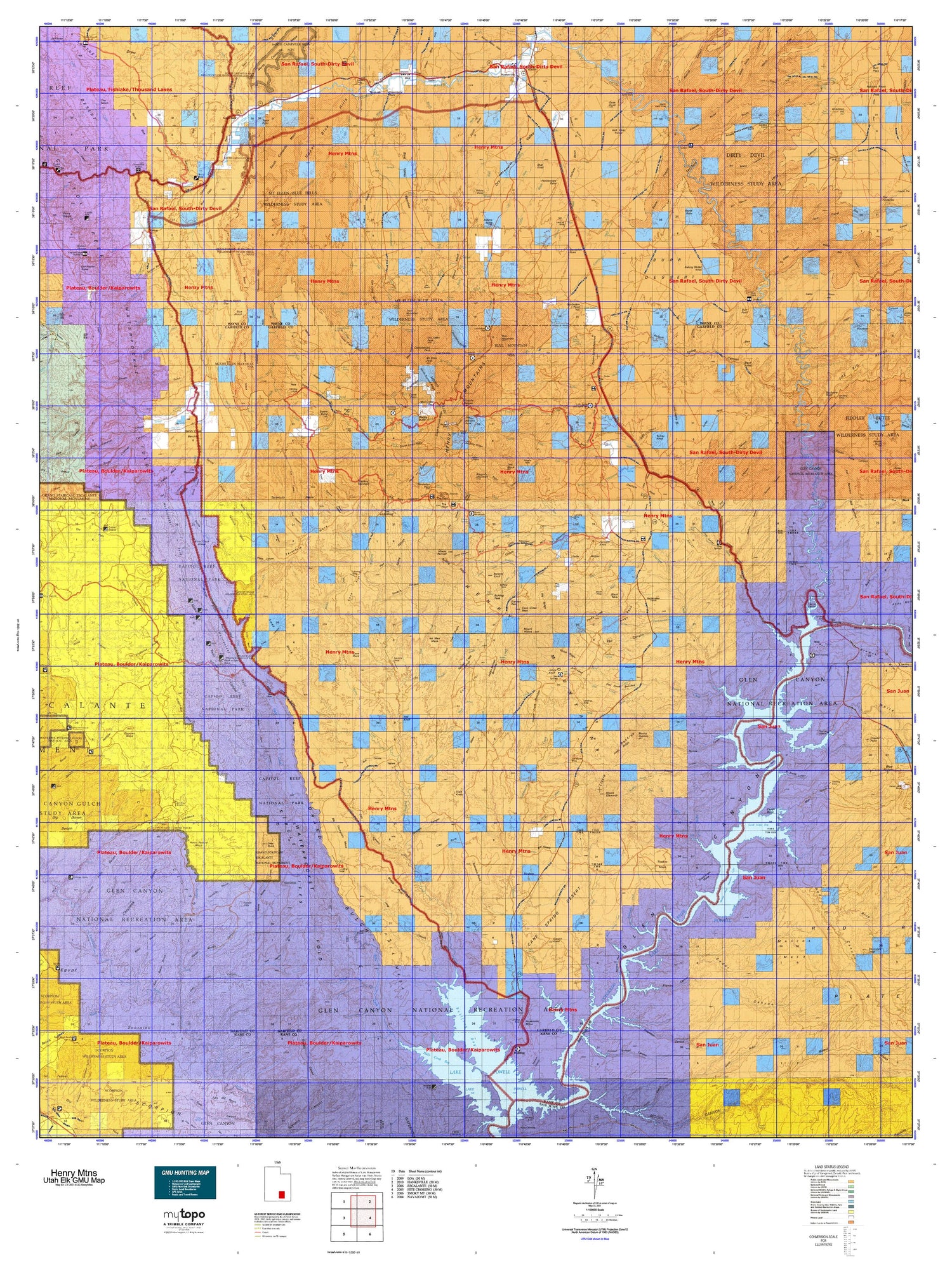
Hunting unit map of Utah Game Management Unit ELK-HenryMtns with topographic lines and unit boundaries. This topo map features UTM / MGRS and Latitude/Longitude grids, plus public land ownership. It comes folded on waterproof paper. Be fully prepared for your hunt with a MyTopo GMU map!.
This map contains the following named places: Adams Butte,Aldrich,Angel Point,Ant Knoll,Ant Knolls,Baker Ranch,Baking Skillet Knoll,Bartons Peak,Bastian Reservoir,Beaver Wash,Beef Hollow Reservoir,Benson Creek,Bert Mesa,Biddlecome Ranch,Big Thomson Mesa,Birch Creek,Bitter Creek,Black Creek,Black Mesa,Black Table,Blind Trail Wash,Blue Knoll,Browns Creek,Browns Knoll,Buckacre Point,Bull Creek,Bull Mountain,Bulldog Creek,Bulldog Peak,Bulldog Ridge,Bullfrog,Bullfrog Basin Campground,Bullfrog Creek,Bullfrog Creek Overlook,Burr Point,Burro Wash,Caineville,Caineville Wash,Capitol Reef Campground,Capitol Reef National Park,Capitol Wash,Cass Creek,Cass Creek Peak,Cass Creek Reservoir,Castle Butte,Cave Point,Cedar Creek,Cedar Mesa,Cedar Mesa Campground,Chocolate Drop,Clay Point,Coal Bed Mesa,Cocks Comb,Colt Mesa,Copper Creek,Copper Point,Corral Point,Cottonwood Creek,Cottonwood Wash,Coyote Creek,Coyote Reservoir,Crescent Creek,Dandy Crossing,Danish Knoll,Deadman Hill,Deep Creek,Deer Heaven,Desert Overlook,Dials Knob,Dirty Devil River,Dry Fork,Dry Lake Flat,Dry Lakes Peak,Dry Wash,Dugout Creek,Durfey Butte,Eagle City,East Garfield Division,East Gate Reservoir,Eggnog,EPH Hanks Tower,Fairview Ranch,Farmers Knob,Fiddler Butte,Fivemile Wash,George Hobbs Historical Site,Gibex Point,Giles,Gilex,Gold Creek,Golden Throne,Good Hope,Good Hope Mesa,Granite Creek,Granite Ranch,Guss Knoll,Hall Mesa,Halls Creek,Hanksville,Hanksville Division,Hansen Creek,Hite,Hite Crossing,Hite Marina,Hite Marina Campground,Hog Spring Picnic Area,Hog Springs Campground,Hog Springs Picnic Area,Horse Mesa,Horse Pasture Mesa,Hoskinnini Mesa,Jacobs Rock,Johns Knoll,Juds Knoll,Kimble and Turner Peak,King Ranch,Lake Powell Overlook,Lamp Stand,Left Fork Slate Creek,Little Egypt Geologic Site,Little Rockies National Natural Landmark,Lone Cedar Reservoir,Lonesome Beaver Campground,Lost Spring Reservoir,Lost Spring Wash,Maidenwater,Maidenwater Reservoir,Mancos Mesa,McMillan Springs Campground,Meadow Gulch Reservoir,Middle Fork Ticaboo Creek,Middle Point,Milk Creek,Milk Creek Reservoir,Millers Creek,Monte Cristo Island,Moody Creek,Mount Ellen Creek,Mount Ellen Peak,Mount Ellsworth,Mount Hillers,Mount Holmes,Mount Pennell,Mud Creek,Muley Creek,National Park Service Headquarters,Nicks Peak,No Man Mesa,North Fork Bullfrog Creek,North Fork Pistol Creek,North Fork Silver Falls Creek,North Fork South Creek,North Fork Ticaboo Creek,North Point,North Wash,Notom,Oak Creek,Oak Creek Point,Painted Hill RV Park,Peak-a-boo Rock,Pennell Creek,Pennell Creek Roughs,Peshliki Fork,Pioneer Mesa,Pioneer Register,Pistol Creek,Pleasant Creek,Pleasant Creek Ranch,Purple Hills,Quaking Aspen Creek,Ragged Mountain,Raggy Draws,Red Monument,Rock Corral,Saleratus Point,Saleratus Wash,Sams Mesa,Sandstone Knolls,Sandy Creek,Sandy Ranch,Saw Tooth,Sevenmile Creek,Shitamaring Creek,Shootaring Point,Slate Creek,Smith Fork,South Caineville Mesa,South Creek,South Fork Oak Creek,South Fork Pistol Creek,South Fork Swett Creek,South Fork Ticaboo Creek,South Pinto Hills,Speck Creek,Star Creek,Star Springs Campground,Steamboat Point,Steele Butte,Stevens Mesa,Straight Creek,Strike Valley Overlook,Studhorse Peaks,Swap Mesa,Sweetwater Creek,Swett Creek,Table Mountain,Tarantula Mesa,The Block,The Hartnet,The Horn,The Post,The Salmon,Thompson Creek,Thompson Mesa,Three Forks,Ticaboo,Ticaboo Creek,Ticaboo Mesa,Ticaboo Reservoir,Town of Hanksville,Town Point,Trachyte Creek,Trachyte Ranch,Turkey Knob,Turn of Bullfrog,Twentyfive Mile Wash,Wagon Box Mesa,Warm Springs Creek,Wayne County,White Canyon,White Canyon Creek,White Point,Wildcat Mesa,Willow Creek,Wolverine Petrified Wood Area


