MyTopo
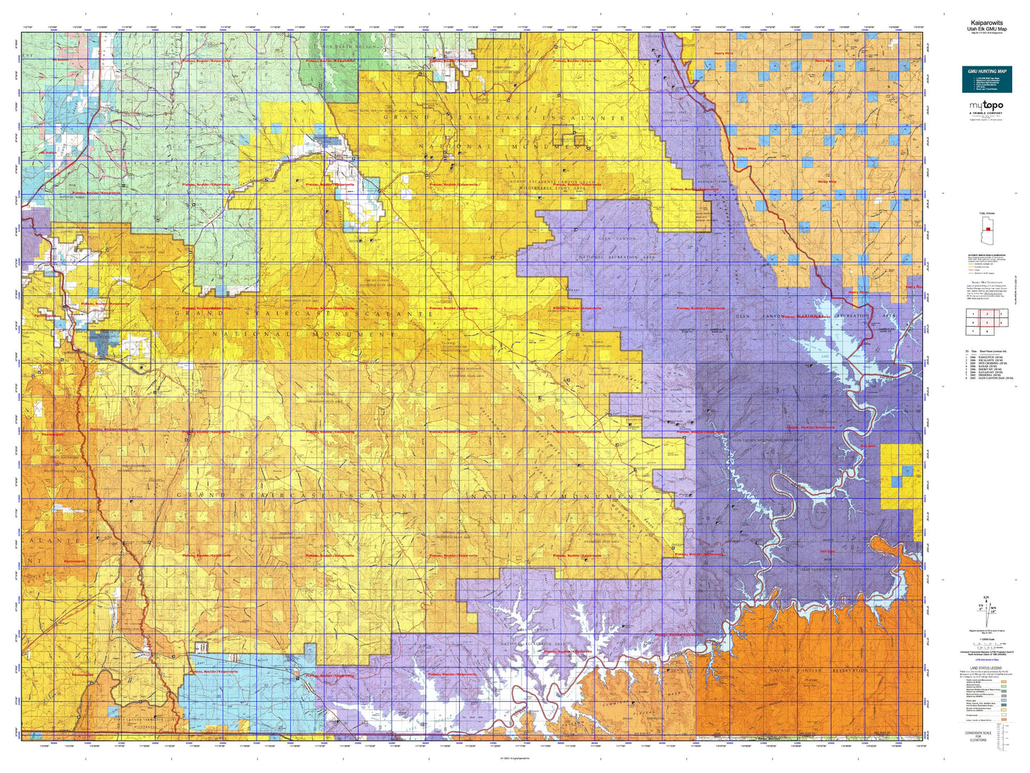
Utah Elk GMU Kaiparowits Map
Couldn't load pickup availability
Hunting unit map of Utah Game Management Unit ELK-Kaiparowits with topographic lines and unit boundaries. This topo map features UTM / MGRS and Latitude/Longitude grids, plus public land ownership. It comes folded on waterproof paper. Be fully prepared for your hunt with a MyTopo GMU map!.
This map contains the following named places: Adairville,Alstrom Point,Anderson Camp,Ant Knoll,Aspen Patch,Aztec Creek,Baker Ranch,Barney Reservoir,Barney Top,Big Hollow Wash,Big Thomson Mesa,Big Water,Billie Flat Top,Blondie Knoll,Boynton Lookout,Bridge Creek,Bull Points,Bullfrog Creek,Bullfrog Creek Overlook,Butler Valley Neck,Butler Valley Reservoir,Calf Creek,Calf Creek Campground,Calf Creek Recreation Area,Calico Peak,Canaan Peak,Cannonville,Carcass Wash,Cathedral Butte,Cave Point,Center Fork Kane Wash,Cha Butte,Cherry Creek,City of Escalante,Clay Point,Clear Creek,Coal Bed Mesa,Collet Top,Colt Mesa,Cookie Jar Butte,Corn Creek,Cottonwood Creek,Cottonwood Wash,Cougar Knoll,Coyote Creek,Coyote Hole,Coyote Point,Dance Hall Rock,Dangling Rope Marina,Davis Point,Death Ridge Reservoir,Deer Creek Campground,Deer Creek Recreation Area,Deer Trails,Desha Creek,Devils Garden,Devils Garden Campground,Devils Garden Outstanding Natural Area,Dials Knob,Dougi Butte,Dry Fork,Dry Rock Creek,Dry Valley Creek,Durffey Mesa,East of the Navajo,Echo Camp,Eggnog,Egypt,Escalante,Escalante District Ranger Station,Escalante Division,Escalante Petrified Forest Campground,Escalante Petrified Forest State Park,Fiftymile Creek,Fiftymile Point,Fivemile Mountain,Flat Top,Fortymile Creek,Garfield County,George Hobbs Historical Site,Georgetown,Glen Canyon National Recreation Area,Grand Bench Neck,Grand Staircase-Escalante National Monument,Gravel Hill,Gregory Butte,Grey Mesa,Griffin Ranch,Gunsight Butte,Hall Mesa,Hall Ranch,Halls Creek,Harris Wash,Haycock Point,Heaps Ranch,Henderson Point,Henrieville,Hogeye Creek,Hole-in-the-Rock Crossing,Hole-in-the-Rock Historical Marker,Horse Creek Top,Horse Lake,Horse Mountain,Horse Pasture Mesa,Hurricane Wash,Indian Creek,Iron Top Mesa,Jepson Ranch,Jodey Point,Johnson Storage Reservoir,Johnson Store Butte,Kanab Division,Kane County,Kane Point,King Mesa,Kirbys Point,Kitchen Corral Point,Kodachrome Basin Campground,Kodachrome Basin State Park,Lake Powell,Last Chance Creek,Left Fork Carcass Wash,Left Fork Kane Wash,Les George Point,Little Alstrom Point,Losee,Lower Slickrock,Marts Pasture,Mazuki point,McGath Point,Middle Point,Middle Warm Creek Point,Millers Creek,Mogui Motel Campground,Mollies Nipple,Moody Creek,Mud Creek,Mudholes Point,Muley Creek,Mustard Point,Nasja Creek,Nasja Mesa,Navajo Begay,Navajo Mountain Trailhead,Navajo Mountain Trailhead to Rainbow Bridge,Navajo Point,Needle Eye Point,Nipple Butte,Nipple Creek,Nipple Lake,Nipple Ranch,No Mans Mesa,North Creek Reservoir,North Escalante Canyon Outstanding Natural Area,North Fork Silver Falls Creek,Oak Glens,Oley Knolls,Ott Ranch,Padre Creek,Padres Butte,Painted Rocks,Paria,Paria Ranger Station,Pasture Point,Peak-a-boo Rock,Pennell Creek,Phipps-Death Hollow Outstanding Natural Area,Pilot Knoll,Pine Lake,Pine Lake Campground,Pioneer Mesa,Pleasant Grove,Poor Mans Placer,Potters Butte,Powell Camps,Powell Point,Prickly Pear Point,Purple Hills,Rainbow Bridge Floating Marina,Rainbow Bridge National Monument,Rainbow City,Register Rock,Reynolds Spring Reservoir,Riddle Ranch,Romana Bench,Romana Mesa,Roundy Ranch,Rush Beds,Saleratus Point,San Juan Placer Claim,San Juan Southern Paiute Northern Area,Shepherd Point,Ship Mountain Point,Shurtz Bush,Shute Point,Sinking Ship,Slickrock Water,Smith Run,Sooner Rocks,Spencer Point,Spring Point,Star Seep,Steer Point,Stony Point,Swap Mesa,The Blues,The Gulch Outstanding Natural Area,The Post,The V,Town of Big Water,Town of Cannonville,Town of Henrieville,Town of Tropic,Tropic,Tropic Division,Twentyfive Mile Corral,Twentymile Corral,Twin Trees,Twin Trees Campground,Upper Slickrock,Upper Valley Guard Station,Wagon Box Mesa,Warm Creek Cabins,Washboard,West Canyon Creek,West End Point,White House,White Mountain,White Point,White Rocks,Whitehouse Trailhead,Wide Hollow Reservoir,Widtsoe,Widtsoe Junction,Wolverine Petrified Wood Area