MyTopo
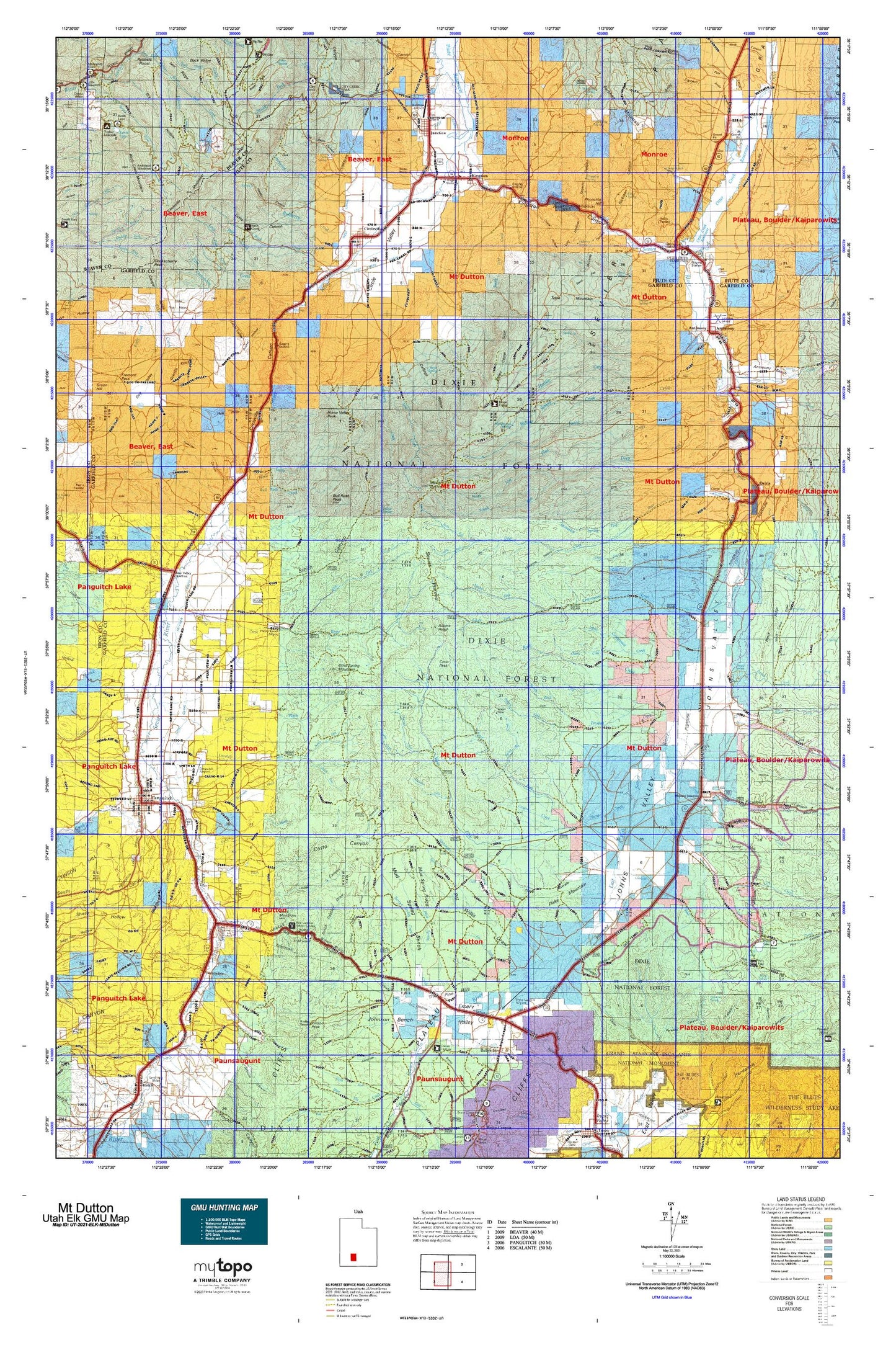
Utah Elk GMU Mt Dutton Map
Couldn't load pickup availability
Hunting unit map of Utah Game Management Unit ELK-MtDutton with topographic lines and unit boundaries. This topo map features UTM / MGRS and Latitude/Longitude grids, plus public land ownership. It comes folded on waterproof paper. Be fully prepared for your hunt with a MyTopo GMU map!.
This map contains the following named places: 84723,84743,84759,Adams Head,Anderson Campground,Anderson Meadow Dam,Anderson Meadow Reservoir,Angle,Antimony,Antimony Bench,Antimony Creek,Barton Tebbs LaFevre Canal,Battle Mountain,Bay Cabin,Bear Creek,Bear Valley Junction,Bendder Pond,Berry Spring Creek,Birch Creek,Birch Creek Mountain,Black Mountain,Blind Spring Mountain,Bone Valley,Brady Creek,Briggs Camp,Briggs Camp Creek,Bucket Hollow Reservoir,Bull Rush Creek,Bull Rush Peak,Bullberry Creek,Burnt Hollow Trail,Butch Cassidy Home,Butler Wash,Cameron Wash,Carter Creek,Casto Wash,Center Creek,Cherry Creek,Chokecherry Creek,Chokecherry Peak,Circleville,Circleville District Ranger Station,Circleville Mountain,City Creek Campground,City of Panguitch,Clarence Creek,Clark Bench,Clay Creek,Corral Flat Reservoir,Cottonwood Basin,Cottonwood Creek,Cottonwood Peak,Cow Creek,Coyote Lake,Crow Peak,Dalley Ditch,Deep Creek,Deer Creek,Deer Lake,Dry Creek,Dry Fork,Dry Fork Rock Creek,Dry Lake,Dry Wash,East Bench,East Bench Canal,East Fork Canal,East Fork Hunt Creek,East Fork Sevier River,East Panguitch Canal,Echard Creek,Emery Valley,Fishermans Bench Recreation Site,Flake Mountain,Flat Top,Forest Creek,Forshea Mountain,Forshea Trough,Fullmers Cabins,Garfield County Fairgrounds,Granite Knolls,Granite Pond,Granite Valley,Hancock Creek,Hancock Fork,Hancock Peak,Henderson Point,Hillsdale,Hitch-N-Post Campground,Hoodle Creek,Horse Bench,Horse Creek,Horse Valley Peak,Hunt Creek,Iant Creek,Joes Pond,John L Swale,Johnson Bench,Johnsonville Site,Jones Corral Guard Station,Jones Corral Reservoir,Judd Creek,Judd Pasture Troughs,Junction,Kents Lake,Kents Lake Campground,Kingston,Kingston Canal,LeBaron Creek,LeBaron Lake,Left Fork Sanford Creek,Limekiln Creek,Lion Rock,Little Cottonwood Creek,Little Cow Creek,Little Dog Valley Peak,Little Meadows,Little Pine Creek,Little Valley,Long Canal,Lossee Canal,Lost Creek,Lost Creek Canal,Lower Kents Lake,Malmsten Peak,Marks Pond,Marshall Ditch,Marshall Meadow,McEwen Ditch,Middle Creek,Middle Pine Creek,Miry Creek,Mount Dutton,Mount Pierson,Mountain Spring Fork,Mountain Spring Reservoir,Mud Lake,Mud Spring Bench,Mud Spring Creek,Mule Flat Reservoir,Mumford Reservoir,North Creek,North Fork Birch Creek,North Fork Cottonwood Creek,North Fork Deep Creek,North Fork Deer Creek,North Fork Limekiln Creek,North Fork Prospect Creek,Oak Basin,Old State Ditch,Osiris,Otter Creek,Otter Creek Campground,Otter Creek Reservoir,Otter Creek State Park,Panguitch,Panguitch Canal,Panguitch Creek,Panguitch Division,Panguitch KOA,Parker Peak,Peterson Wash,Phonolite Hill,Pine Creek,Pine Lake,Pine Lake Campground,Pink Cliffs Village,Poison Creek,Pole Creek,Powell District Ranger Station,Powell Survey Cairn,Prospect Creek,Ranch Creek,Ranger Pasture,Red Canyon Campground,Reynolds Spring Reservoir,Riddle Lake,Riggs Pond,Right Fork Sanford Creek,Rim Reservoir,Road Hollow Reservoir,Rock Creek,Rock Lake,Rocky Ford Creek,Rocky Ford Reservoir,Rocky Ford Trail,Roller Mill Hill,Sams Cabin,Sand Wash,Sand Wash Bench,Sandy Creek,Sanford Creek,Seed Lakes,Senseball Lake,Shinglemill Swale,Showalter Bench,Showalter Creek,Smiths Reservoir,South Creek,South Ditch,South Fork Birch Creek,South Fork City Creek,South Fork Cottonwood Creek,South Fork Deep Creek,South Fork Deer Creek,South Fork Limekiln Creek,South Fork Prospect Creek,Spring Creek,Spry,Straight Creek,Sweetwater Creek,Table Mountain,The Pine Hills,The Triangle,Three Creeks,Threemile Creek,Town of Antimony,Town of Bryce Canyon City,Town of Circleville,Town of Junction,Town of Kingston,Tropic Division,Twin Peaks,Upper Kents Lake,Wards Cache,West Canal,West Ditch,West Fork Hunt Creek,Widtsoe,Widtsoe Junction,Wildcat Creek,Willow Spring Creek,Wilson Peak,Window Rock,Wood Lake