MyTopo
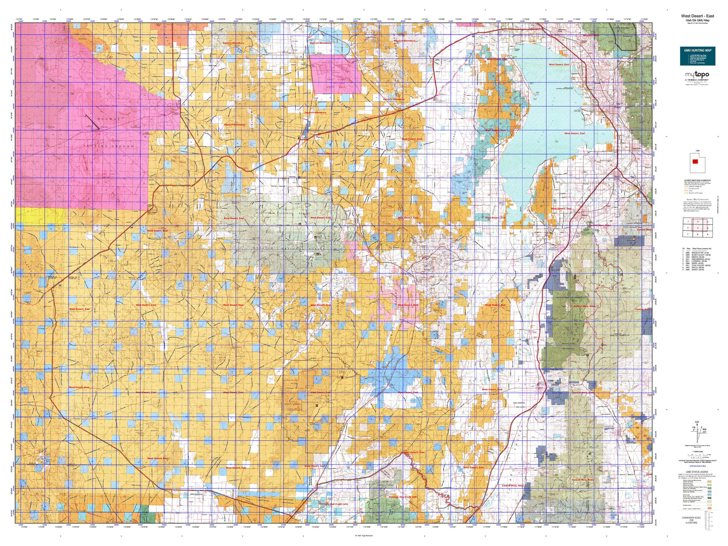
Utah Elk GMU West Desert - East Map
Couldn't load pickup availability
Hunting unit map of Utah Game Management Unit ELK-WestEast with topographic lines and unit boundaries. This topo map features UTM / MGRS and Latitude/Longitude grids, plus public land ownership. It comes folded on waterproof paper. Be fully prepared for your hunt with a MyTopo GMU map!.
This map contains the following named places: Able Area,Allens Ranch,Allison Knolls,Andys Pond,Atherley Reservoir,Baker Area,Bald Mountain,Benjamin,Big Drum Reservoir,Big Hill,Bismark Peak,Bittner Knoll,Bittner Knoll Reservoir,Black Crook Peak,Black Mountains,Black Peak,Boulter,Boulter Peak,Boulter Summit,Brough Reservoir,Buckhorn Mountain,Bunker,Bureau of Land Management Campground,Burriston Ponds,Camp Floyd State Historical Site,Cap Peak,Cat Hill,CCC Camp Site,CCC Reservoir,Cedar Knolls,Cedar Mountain,Center,Champlin,Champlin Peak,Charlie Area,Cherry Creek Reservoir,Chicken Rock,Christenson Windmill,Clover Station,Clyde Knoll,Clyde Ranch,Coyote Knoll,Coyote Knoll Reservoir,Crater Bench Reservoir,Crater Reservoir,Cup Butte,Davis Knolls,Davis Mountain,Dennis,Desert Mountain,Desert Mountain Reservoir,Diamond,Dividend,Dog Area,Dog Lake,Dog Valley Reservoir,Dry Lake,Dry Mountain,Dugway,Dugway Pony Express Station,Dutch Peak,Eagle Hill,Eagle Mountain,East Dugway Reservoir,East Topaz 2 Reservoir,Erickson Knoll,Eureka,Eureka Peak,Ewell Regulating Reservoir,Fairfield,Faust,Flat Hills,Fox Area,Fumarole Butte,Geneva,Genola,Godiva Mountain,Gorder,Goshen,Goshen Hill,Goshen Reservoir,Grassy Mountain,Greeley Hill,Gypsum Mill,Hancock Ranch,Hannifin Peak,Hannifin Ranch,Harvey Knoll,Hassel Ranch,Hillside,Hogback Reservoir,Hole in Rock Reservoir,Homansville,Horse Heaven Mountain,Horseshoe Hill,Indian Peaks,Iron Hill,Irons Reservoir,J Hill,James Ranch,Jericho,Jericho Campground,John Jones Hill,Joy,Juab,Keg Mountain,Keg Mountain Ranch,Keigley,Knight,Knightville,Lady Laird Peak,Lake Shore,Lakeview,Lant,Leamington,Levan,Levan Peak,Lime Peak,Lion Hill,Lion Peak,Little Davis Mountain,Little Granite Mountain,Little Hill,Little Mountain,Lofgreen,Long Point,Lower Topaz Reservoir,Lynndyl,Mack,Mahogany Hill,Mammoth,Mammoth Junction,Mammoth Peak,Maple Peak,Marble Hill,McIntyre,Mercur,Mineral Hill,Mollies Nipple,Mona,Mona Reservoir,Monument Reservoir,Mosida,Mount Laird,Mount Nebo,Nephi,Nooning Ground,North Hill,North Peak,North Sugarville Reservoir,North Table Mountain Reservoir,O P Rockwell Ranch,Old Baldy,Packard Peak,Parley,Payson,Payson Station,Pehrson,Picture Rock Hills,Picture Rock Reservoir,Picture Rock Wash Reservoir,Pinyon Peak,Pismire Knolls,Poker Knoll,Powder Knoll,Rain Lake,Rattlesnake Peak,Red Lake,Red Pine Mountain,Red Skin Knolls,River Bed Reservoir,Riverbed Pony Express Station,Rockwell Ranch,Rocky Ridge,Round Knoll,Round Top,Sabie Mountain,Salamander Lake,Salt Creek Peak,Sand Hills,Sand Mountain,Santaquin,Santaquin Debris Basin Reservoir,Sharp,Silver City,Simpson Buttes,Simpson Point,Sioux Peak,Site of Rush Valley Pony Express Station,Snell Ranch,Soma,South Apex Hill,South Desert Mountain Reservoir,Spring Lake,Stage Coach Inn State Historical Site,Starr,Sugarloaf,Sunrise Hill,Sunrise Peak,Sunshine,Swasey Hardpan Reservoir,Table Mountain,Tanner Reservoir,Tenmile Hill,Terra,The Knoll,The Knolls,The Summit,Thorpe Hills,Tintic Junction,Tintic Mountain,Tintic Station,Topliff,Topliff Hill,Townsend,Treasure Hill,U S Steel Corporation Reservoir,Uisco,Utah Lake,Valley Reservoir,Vernon,Vernon Reservoir,Vineyard,Wanlass Hill,Warehouse Rock,Warm Springs Mountain,West Fork Reservoir,West Hills,West Mercur,West Mountain,Whirlwind Reservoir,White Knoll,White Lake,White Rock,Wig Mountain