MyTopo
Washington GMU 181 Couse Map
Couldn't load pickup availability
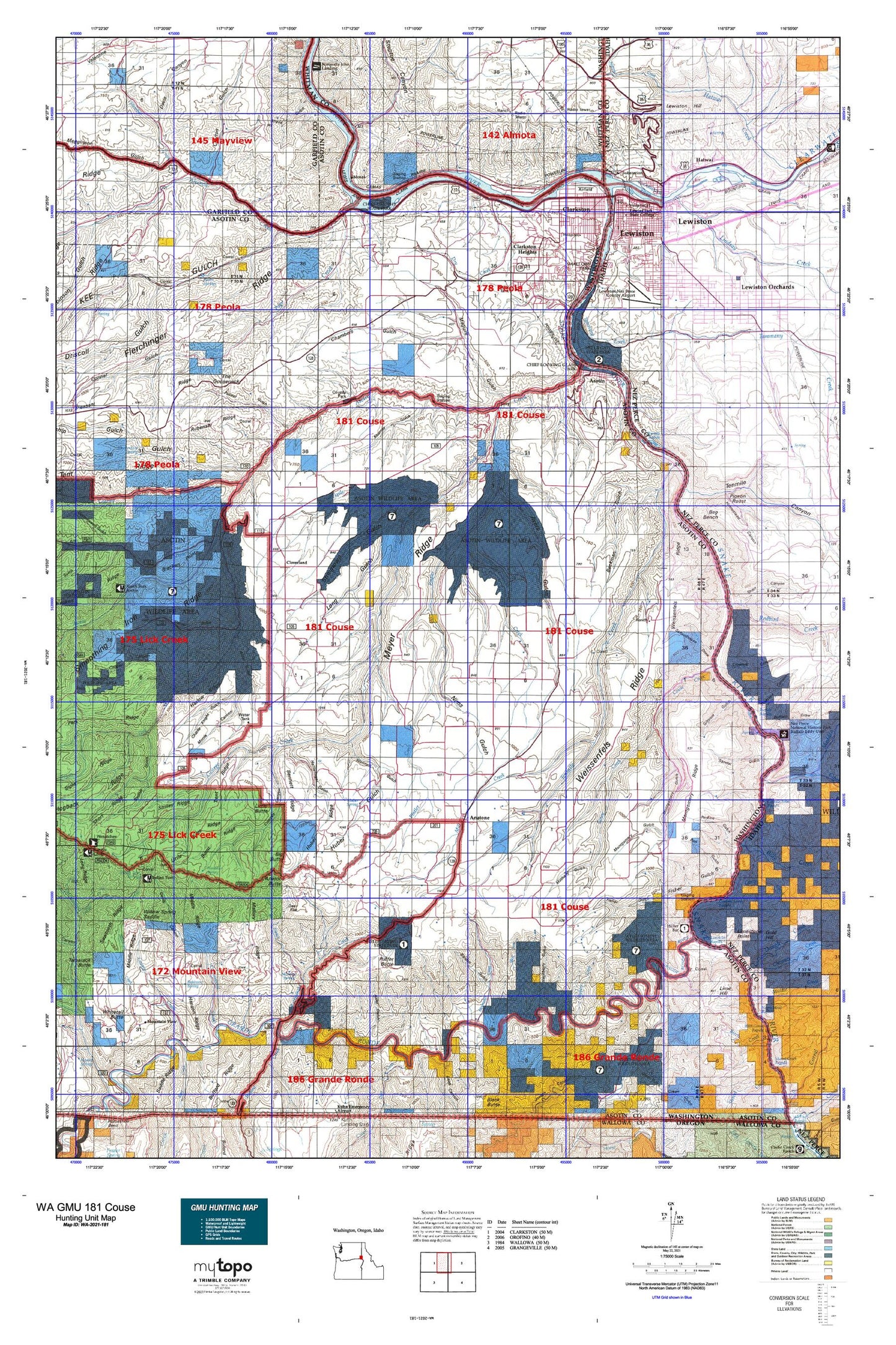
Hunting unit map of Washington Game Management Unit 181 with topographic lines and unit boundaries. This topo map features UTM / MGRS and Latitude/Longitude grids, plus public land ownership. It comes folded on waterproof paper. Be fully prepared for your hunt with a MyTopo GMU map!.
This map contains the following named places: 99401,99402,99403,Ackerman Bar,Airway Park,Alder Gulch,Allen Gulch,Alpowa,Alpowa Creek,Anatone,Anatone Butte,Anatone Census Designated Place,Arthur Weiss Ranch,Asotin,Asotin County,Asotin County Heliport,Asotin Creek,Asotin Dam,Asotin Division,Asotin State Wildlife Recreation Area,Ausman Ranch,Autrey Cemetery,Ayers Gulch,Ayers Ridge,Bachelor Gulch,Beachview Park,Beckman Gulch,Bennett Ridge,Benson Ridge,Big Bench,Big Butte,Billy Creek,Black Ranch,Blankenship Gulch,Bob Gulch,Box Gulch,Bracken Point,Buford Creek,Burnt Ridge,Camp Creek,Captain Lewis Rapids,Chambers Gulch,Charley Creek,Charlie Knight Gulch,Charlie Knight Ranch,Chief Lookin Glass Marina,Chief Looking Glass Marina,Chief Looking Glass Park,Chief Timothy State Park,Chimney Creek,Chimney Ridge,City of Asotin,City of Clarkston,City of Lewiston,Clarkston,Clarkston Division,Clarkston Golf and Country Club,Clarkston Heights,Clarkston Heights-Vineland Census Designated Place,Clarkston Shopping Center,Clayton Gulch,Clearwater River,Cloverland,Conner Gulch,Coombs Canyon,Cooper Canyon,Corral Ridge,Cottonwood Creek,Cougar Creek,Couse Creek,Craige,Crowers Canyon,Dark Canyon,Dark Canyon Creek,Davis Canyon,Deer Flat,Devils Canyon,Dough Creek,Driscoll Gulch,Dry Creek,Dry Gulch,E A Parsons Ranch,East Fork Cottonwood Creek,Edeburn Gulch,Eugene Gulch,Fields Spring State Park,Fisher Gulch,Forebay,Foster Park,Garden Gulch,Gateway Square,George Creek,Gilmore Gulch,Grahams Landing,Grande Ronde River,Gurney,Hackberry Gulch,Hanson Ridge,Harlow Ridge,Hatwai,Hawks Run Airport,Headgate County Park,Hefflefinger Gulch,Hells Gate State Recreation Area,Hells Gato Marina,Hidden Lake,Highland,Holbrook Island,Homestead Canyon,Hoskins Gulch,Huber Gulch,Huber Lake,Huber Ridge,Jerry,Jim Barkley Ranch,Joseph Creek,Kearney Gulch,Kelly Creek,Lathrop Gulch,Lewiston,Lewiston Golf and Country Club,Lewiston Hill,Lewiston Orchards,Lewiston Shopping Center,Lewiston-Nez Perce County Airport,Lick Creek,Lime Hill,Limekiln Rapids,Limestone Point,Lindsay Creek,Little Butte,Little Butte Ridge,Long Gulch,Lost Cabin Ridge,Maguire Gulch,Mallory Ridge,Mark Means Park,Matheny Gulch,McGuire Creek,Medicine Creek,Megginson Gulch,Meyer Ridge,Middle Creek,Middle Ridge,Mill Creek,Montgomery Gulch,Montgomery Ridge,Morris Canyon,Moses,Mountain View,Mullin Spring Gulch,Myers Creek,Nims Gulch,Nisqually John Landing,North Fork Asotin Creek,North Lewiston,O and M Facilities Heliport,Page Creek,Palmer Gulch,Perkins Gulch,Petty Gulch,Petty Ridge,Pigeon Roost,Pintler Creek,Pow Wah Kee Creek,Pow Wah Kee Gulch,Powe Gulch,Puffer Butte,R Barber Ranch,Rattlesnake Creek,Raymond Blankenship Ranch,Redbird Creek,Redhill Gulch,Rice Creek,Rockpile Creek,Rogersburg,Rogersburg Airport,Rubenser Ridge,Schoolhouse Draw,Sheep Gulch,Sheriff Gulch,Sherry Grade,Short Canyon,Short Ridge,Shumaker Creek,Silcott,Silcott Island,Slippery Creek,Smiley Ridge,Smith Gulch,Smooth Gulch,Snake River Seaplane Base,South Fork Asotin Creek,Southgate Plaza,Stember Creek,Steptoe Canyon,Steptoe Creek,Steptoe Lower Range,Stout Ranch,Stringtown Gulch,Stuart Canyon,Sunset Center,Sunset Palisades Dam,Swallows Nest,Swallows Nest Golf Club,Swallows Park,Sweitzer Ridge,Tam Tam Ridge,Tammany Creek,Tenmile Canyon,Tenmile Creek,Tenmile Rapids,The Gooseneck,The Narrows,Theon,Transfer,Trent Ridge,Twin Gulch,Unfried Gulch,Valley View Heights,Vernon Park,Vineland,Vollmer Park,Warner Gulch,Weissenfels Ridge,West Branch Rattlesnake Creek,West Clarkston,West Clarkston-Highland Census Designated Place,West Fork Myers Creek,Westgate Shopping Center,Whitney Gulch,Wolf Gulch,Wormell Gulch,Yellow Pine Gulch,Zindel