MyTopo
Washington GMU 247 Entiat Map
Couldn't load pickup availability
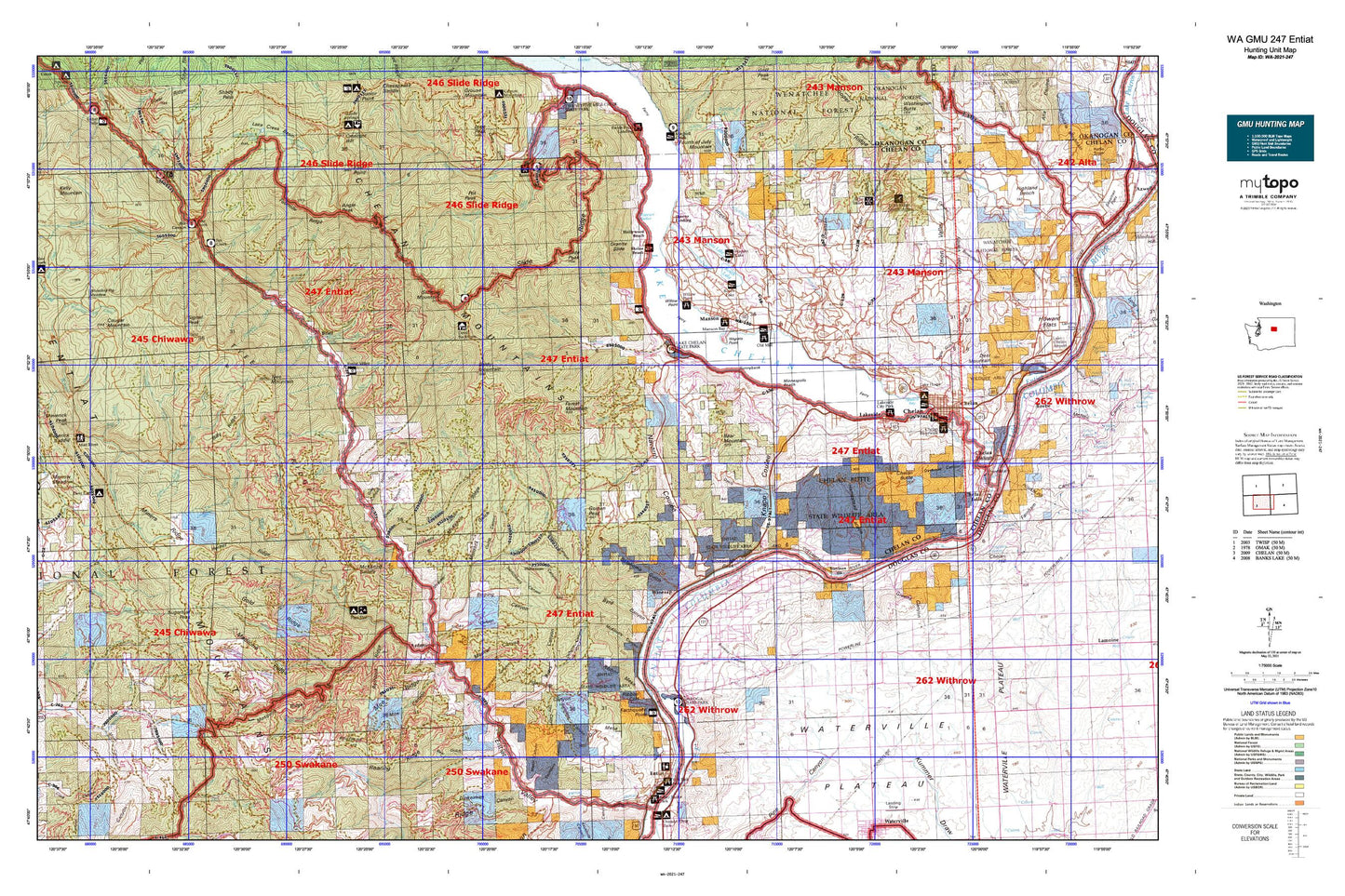
Hunting unit map of Washington Game Management Unit 247 with topographic lines and unit boundaries. This topo map features UTM / MGRS and Latitude/Longitude grids, plus public land ownership. It comes folded on waterproof paper. Be fully prepared for your hunt with a MyTopo GMU map!.
This map contains the following named places: 98811,98831,98843,Alma Creek,Angle Peak,Antilon Lake Dam,Ardenvoir,Baldy Creek,Baldy Mountain,Barrett Creek,Bear Creek,Bear Gulch,Bear Lake,Bear Mountain,Bear Mountain Ranch Golf Course,Beaver Spring,Bergman Gulch,Billy Creek,Billy Ridge,Bisping Canyon,Box Canyon,Brays Landing Cemetery,Brennegan Creek,Brief,Browns Canyon,Burns Creek,Byers Canyon,Byrd Canyon,Cagle Gulch,Camp Nine,Canyon Ranch,Chelan,Chelan Butte,Chelan Butte State Wildlife Area,Chelan County Park,Chelan Division,Chelan Ferry Landing,Chelan Fraternal Cemetery,Chelan Mountains,Chelan Ranger Station,Chelan River Boat Launch,Chelan Riverwalk Park,Cherry Spring,City of Chelan,City of Entiat,Cooper Gulch,Corral Canyon,Cougar Creek,Cougar Creek Shelter,Cougar Meadow,Cougar Mountain,Coyote Spring,Crum Canyon,Darby Draw,Darnells,Davis Canyon,Decker Canyon,Devils Backbone,Devils Backbone Trailbike Loop Trail,Dick Mesa,Dill Creek,Dissmore Canyon,Dover Flat,Dry Creek,Dry Lake,Earthquake Point,East Fork Joe Creek,East Point,East Van Creek,Echo Valley Ski Area,Entiat,Entiat Cemetery,Entiat Division,Entiat Mountains,Entiat National Fish Hatchery,Entiat Ranger Station,Entiat Sewage Treatment Plant,Entiat State Wildlife Area,Entiat Valley Ski Area,Farris,Ficher Canyon,First Creek,Forest Mountain,Fourmile Ridge,Fourth of July Mountain,Fox Creek,Fox Creek Campground,French Corral,Gene Creek,Gold Ridge,Goman Peak,Goosetail Rock,Grandma Creek,Granite Falls,Granite Falls Creek,Granite Slide,Gray Canyon,Greens Canyon,Greens Landing,Harris Creek,Hollywood Beach,Homestead Canyon,Hornet Creek,Hornet Ridge,Indian Creek,Indian Spring,Joe Creek,Johnson Creek,Jungle Creek,Kloochman Creek,Knapp Coulee,Knapps Hill Tunnel,Lady of the Lake Commercial Dock,Lake Chelan Dam,Lake Chelan Golf Course,Lake Chelan Hills,Lake Chelan State Park,Lake Creek,Lake Creek Campground,Lake Entiat,Lakeshore Park,Lakeside,Lakeside City Park,Lone Peak Campground,Long Spring,Mad River,Manson,Manson Bay Park,Manson Census Designated Place,Manson Division,Manson Ferry Landing,Maple Canyon,Maple Creek,Maplecreek,McCrea Creek,McKay Dam,McKenzie Canyon,McKenzie Ridge,McKenzie Saddle,McKinstry Canyon,McLeans Orchard,Medicine Creek,Medicine Ridge,Medicine Spring,Medsker Canyon,Medsker Spring,Miners Corral,Miners Creek,Miners Ridge,Minneapolis Beach,Missouri Harbor,Moe Canyon,Moe Ridge,Morical Canyon,Mosquito Ridge,Mott Creek,Mud Creek,Mud Spring,Murdock Gulch,Navarre Coulee,North Fork Crum Canyon,North Fork Gray Canyon,North Fork Mud Creek,North Fork Potato Creek,North Fork Thirtyfive Mile Creek,Oklahoma Gulch,Old Mill Park,Osburn Canyon,Palmich Canyon,Pine Flat Campground,Pot Peak,Potato Creek,Preston Creek,Preston Falls,Purtteman Gulch,Railroad Canyon,Ramona Park Campground,Ribbon Cliff,Ribbon Mesa,Ringstead Canyon,Roaring Creek,Roaring Ridge,Rocky Pond Airstrip,Roses Lake,Ross Private Strip,Rothrock Ridge,Roundy Creek,Saunders Canyon,Shamel Creek,Shrine Beach,Signal Peak,Silver Creek,Silver Falls,Silver Falls Campground,Slide Peak,Slide Ridge,Sourdough Creek,South Fork Grays Canyon,South Fork Mud Creek,South Fork Preston Creek,South Shore,Spaders Bay,Stanley Canyon,Stayman,Steliko,Steliko Canyon,Stink Creek,Stormy Creek,Stormy Mountain,Sugarloaf Peak,Sugarloaf Peak Lookout,Sunnybank,Sunshine Canyon,Swanson Gulch,Switchback Canyon,Tillicum Creek,Tiny Canyon,Tommy Creek,Tyee Creek,Tyee Mountain,Tyee Ridge,Wapato Lake,Wapato Lake Dam,Wapato Point,Waterville Plateau,Watsons Harverene,Wilkinson Canyon,Willow Point,Willow Point Park,Wilma Creek,Windy Camp,Windy Creek,Winesap,Young Creek,Young Creek Shelter