MyTopo
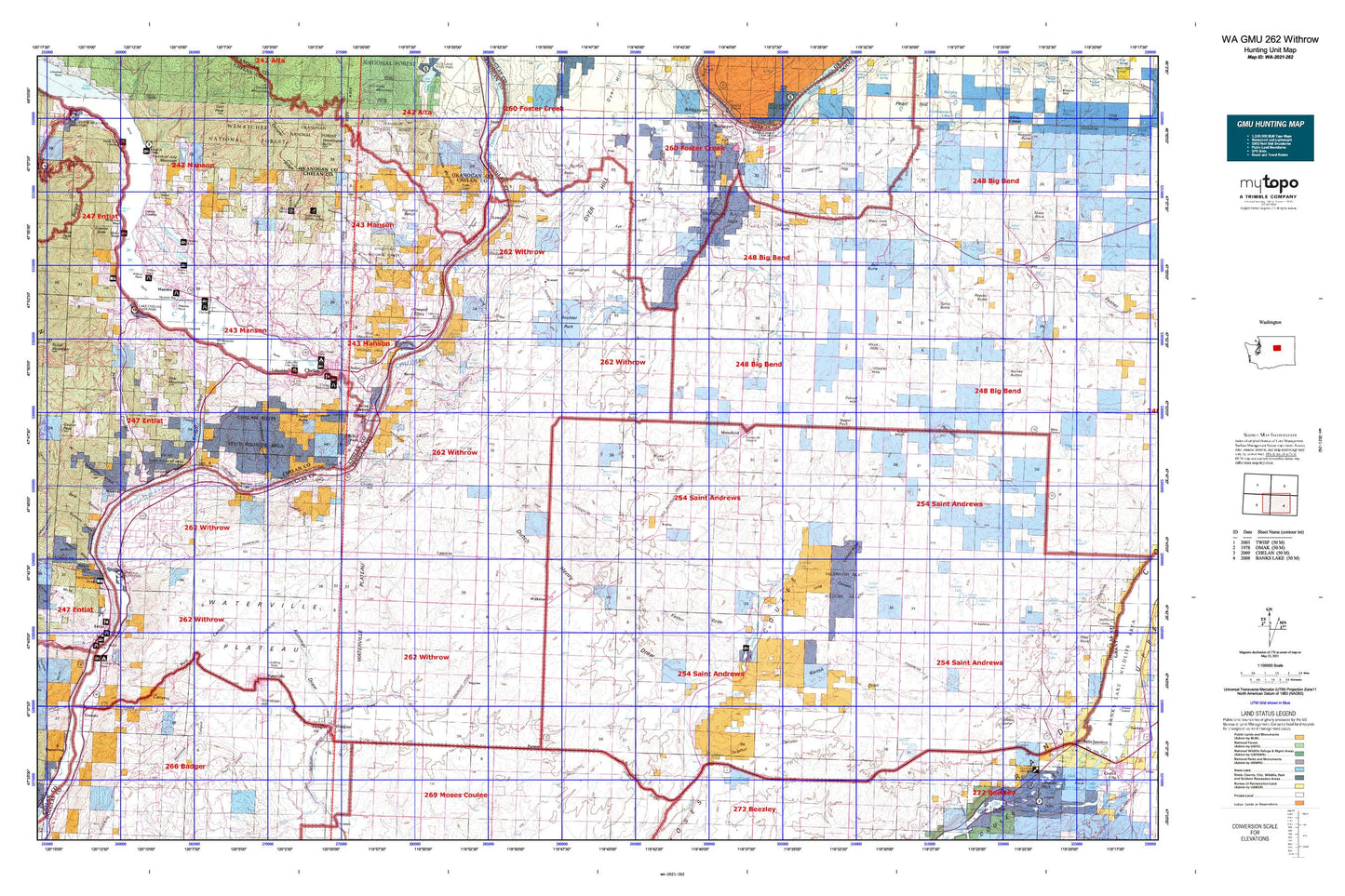
Washington GMU 262 Withrow Map
Couldn't load pickup availability
Hunting unit map of Washington Game Management Unit 262 with topographic lines and unit boundaries. This topo map features UTM / MGRS and Latitude/Longitude grids, plus public land ownership. It comes folded on waterproof paper. Be fully prepared for your hunt with a MyTopo GMU map!.
This map contains the following named places: 98817,98830,98831,98843,98858,Alkali Wells,Antilon Creek,Antilon Lake,Antilon Lake Campground,Antilon Lake Dam,Antilon Saddle Dam Number Two,Antoine Creek,Apple Acres Mobile Village,Arbuckle Mountain,Atkins Lake,Azwell,Badger Wells,Baird,Barrett Creek,Bear Creek,Bear Mountain,Bear Mountain Ranch Golf Course,Beard Lake,Beebe,Beebe Bridge Park,Bell Butte,Bennett Lake,Bergman Gulch,Bigelow Canyon,Bonita,Bonita Flats,Boulder Park,Bridgeport Division,Brownfield Canyon,Browns Canyon,Buckingham,Buckingham Draw,Buckingham Flats,Buckingham Grove,Burke Hill,Burton Draw,Byrd Canyon,Cagle Gulch,Canyon Ranch,Carter Hill,Chalk Hills,Chapman Draw,Chelan,Chelan Butte,Chelan Butte State Wildlife Area,Chelan County Park,Chelan Falls,Chelan Falls Park,Chelan Falls Powerhouse Park,Chelan Ferry Landing,Chelan Hill,Chelan Ranger Station,Chelan River,Chelan River Boat Launch,Chelan Riverwalk Park,Chelan Sewage Treatment Plant,Chelan State Fish Hatchery,Chelan Station,Chester Butte,City of Chelan,City of Entiat,Cold Springs Basin,Coleman Hill,Collins Canyon,Cooper Gulch,Corbaley Canyon,Cornehl Lake,Corral Creek,Darnells,Davis Canyon,Daybreak Canyon,Deep Creek,Deer Mountain,Douglas,Douglas County,Douglas Draw,Dover Flat,Downey Spring,Dry Lake,Dutch Henry Draw,Dyer,Dyer Hill,Earthquake Point,East Fork Joe Creek,East Foster Creek,Echo Valley Ski Area,Entiat,Entiat Ranger Station,Entiat Sewage Treatment Plant,Entiat State Wildlife Area,Evergreen Camp,Fairview,Farmer,Farnham Canyon,Ficher Canyon,Fields Point,Fields Point Landing,First Creek,Fisher Lakes,Foster Creek Wildlife Recreation Area,Fourth of July Mountain,Fye Draw,Gallagher Flat State Wildlife Recreation Area,Goosetail Rock,Gossman Flats,Granite Falls,Granite Falls Creek,Green Lake,Greens Canyon,Greens Landing,Grimes Lake,Hendricks Draw,Henton Lake,Highland,Highland Bench,Hollywood Beach,Homestead Canyon,Hook Hills,Howard,Howard Flats,Hugo Siding,Ice Caves State Park,Jameson,Jameson Lake,Joe Creek,Johnson Creek,Jorgensen Dam,Kester Draw,Knapp Coulee,Kummer Draw,Lady of the Lake Commercial Dock,Lake Chelan Dam,Lake Chelan Golf Course,Lake Chelan Hills,Lake Chelan State Park,Lake Entiat,Lakeshore Park,Lakeside,Lakeside City Park,Lamoine,Landingham Hill,Lone Butte,Long Canyon,Long Draw,Mansfield,Manson,Manson Bay Park,Manson Division,Manson Ferry Landing,Maple Creek,Maplecreek,Marion Hill Spring,Mary Jane Hill,Matthiesen,McGinnis Canyon,McKay Dam,McLeans Orchard,McNeil Canyon,Meyer Ranch,Middle Foster Creek,Minneapolis Beach,Missouri Harbor,Mitchell Creek,Mitchell Creek Campground,Mud Spring,Mud Spring Community Club,Navarre Coulee,Okanogan City,Oklahoma Gulch,Old Mill Park,Pattie Big Spring,Peaceful Valley,Penny Lake,Perk Lake,Piersol Hills,Pine Canyon,Pot Hills,Prang,Purtteman Gulch,Roses Lake,Rudd Lake,Rummel Lake,Saint Hubert,Sheep Trough Draw,Shrine Beach,Silicosaska Park,Skeleton Canyon,Smith Draw,Sourdough Flats,South Shore,Spaders Bay,Spiva Butte,Spray Canyon,Standpipe Hill,Stayman,Stink Creek,Stormy Point,Sulphur Canyon,Sunnybank,Supplee,Swanson Gulch,Touhey,Town of Mansfield,Town of Waterville,Tub Springs Lake,Twin Lakes,Union Valley,Wadams Canyon,Wapato Lake,Wapato Lake Dam,Wapato Point,Washington Butte,Washington Creek,Washington Flat,Waterville,Waterville Division,Waterville Plateau,Waterville Sewage Disposal Pond Dam,Watsons Harverene,Wells Dam,West Foster Creek,Wheeler Hills,Will Risk Memorial Park,Willow Point,Willow Point Park,Windsor Hill,Winesap,Withrow,Wolf Draw,Yeager Rock