MyTopo
Washington GMU 278 Wahluke Map
Couldn't load pickup availability
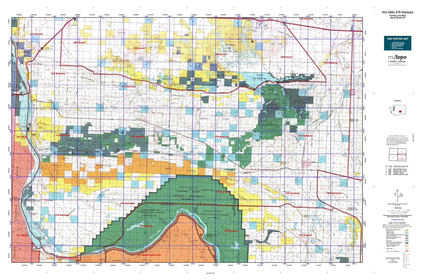
Hunting unit map of Washington Game Management Unit 278 with topographic lines and unit boundaries. This topo map features UTM / MGRS and Latitude/Longitude grids, plus public land ownership. It comes folded on waterproof paper. Be fully prepared for your hunt with a MyTopo GMU map!.
This map contains the following named places: 99321,99349,99357,Anson,B & G Farms Airport,Bailie,Bettie,Beverly,Beverly Census Designated Place,Beverly Junction,Beverly Post Office,Black Lake,Black Lake Dam,Black Lake-Upper,Blythe Lake,Cabin Lake,Caliche Lakes,Canal Lake,Cash Butte,Chadbourne Ranch,Christensen Brothers Wahluke Strip,Christensen Field,Chukar Lake,City of Mattawa,City of Royal City,Columbia National Wildlife Refuge,Corfu,Corral Lake,Coyote Lake,Crab Creek,Crab Creek Habitat Management Area,Crab Creek Lateral,Crab Creek Lateral Extension,Crab Creek Wasteway,Deadman Lake,Desert Aire,Desert Aire Census Designated Place,Desert Aire Regional Airport,Desert Habitat Management Area,Dry Island,Eagle Lake Substation,East White Bluffs,Falcon Lake,Frenchman Hills,Frenchman Hills Lake,Frenchman Hills Pumping Plant,Frenchman Hills Wasteway,Frenchman Springs Pumping Plant,Gearheart Private Airport,Ginger,Goldeneye Lake,Goose Island,Goose Lake Wasteway,Grant County Fire District 10,Grant County Fire District 10 Station 2,Grant County Fire District 10 Station 3 Beverly,Grant County Fire District 10 Station 6 Smyrna,Grant County Fire District 11,Grant County Fire District 11 Station 3,Grant County Fire District 3 Station 34,Grant County Fire District 5 Station 11,Grant County Fire District 8,Grant County Fire District 8 Station 82,Grant County Fire District 8 Station 83,Halfmoon Lake,Hampton Lake,Hanford Reach,Hayes Creek,Heart Lake,Herman Lake,Heron Lake,Hillton Lake,Hutchinson Lake,Jericho,Jericho Substation,KRSC-AM (Othello),KZLN-FM (Othello),Lenice Dam,Lenice Lake,Lind Coulee,Locke Island,Long Lake,Lost Lake,Low Gap,Low Gap Pass,Low Gap Pumping Station,Lower Crab Creek,Lower Goose Lake,Lower Goose Lake Dam,Lower Saddle Gap Pumping Station,Marine View,Marine View Census Designated Place,Marsh Unit One,Marsh Unit One Dam,Mattawa,Mattawa Air Strip,Mattawa Drain,Mattawa Elementary School,Mattawa Police Department,Mattawa-Royal City Division,McMannaman Lake,Merry Dam,Merry Lake,Morgan Lake,Morris Schott Elementary School,Nancy,Natural Corral,North Teal Lake,Nunnally Lake,O'Sullivan Dam,Othello Air Force Station,Para Lake,Pillar Lake,Pit Lakes,Pleasant Valley Cemetery,Potholes Habitat Management Area,Potholes Reservoir,Potholes State Park,Priest Rapids Lake,Rasor Ranch,Red Rock Coulee,Red Rock Elementary School,Red Rock Lake,Rock Check IV-13 Dam,Rock Check IV-14 Dam,Rock Check IV-15 Dam,Rock Check IV-6 Dam,Royal Branch Canal,Royal Branch Canal Wasteway,Royal Camp,Royal City,Royal City Police Department,Royal City Post Office,Royal High School,Royal Lake,Royal Middle School,Royal Slope,Royal Substation,Saddle Gap,Saddle Mountain Lake,Saddle Mountain National Wildlife Refuge,Saddle Mountain Wasteway,Saddle Mountains,Sage Lakes,Sagehill,Sand Hollow,Sand Hollow Lake,Sand Hollow Pumping Station,Sand Lake,Schrum Ranch,Schwana,Schwana Census Designated Place,Seep Lakes Habitat Management Area,Sentinel Bluffs,Sentinel Gap,Sentinel Mountain,Shiner Lake,Smyrna,Smyrna Bench,Soda Lake,Soda Lake Dike Dam,Sourdough Canyon,South Teal Lake,Stillwater Creek Airport,Taggares Dam Number Four,Taggares Dam Number One,Taggares Dam Number Three,Taggares Dam Number Two,Taunton,The Potholes,U and I McNary Number One Reservoir Dam,Upper Goose Lake,Vantage Substation,Wahatis Peak,Wahatis Wasteway,Wahluke,Wahluke Branch Ten Wasteway,Wahluke High School,Wahluke Slope,Wahluke Slope Habitat Management Area,Wanapum Village,Watermaster Headquarters,White Bluffs,White Bluffs Wasteway,Widgeon Lake,Wilson Spring