MyTopo
Washington GMU 334 Ellensburg Map
Couldn't load pickup availability
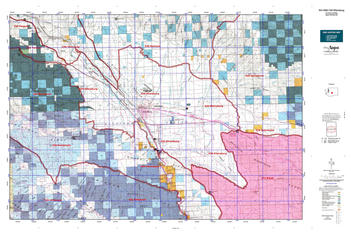
Hunting unit map of Washington Game Management Unit 334 with topographic lines and unit boundaries. This topo map features UTM / MGRS and Latitude/Longitude grids, plus public land ownership. It comes folded on waterproof paper. Be fully prepared for your hunt with a MyTopo GMU map!.
This map contains the following named places: 98926,98934,98946,Ainsley Canyon,Badger Creek,Badger Gap,Badger Pocket,Barnes Cabin,Beiter Airport,Benwy Canyon,Big Burn Canyon,Black Canyon,Black Rock Canyon,Blowout Bench Airport,Bouillon Library,Bowers Field,Box Spring Canyon,Boylston Mountains,Bull Ditch,Burn Canyon,Burnt Canyon,Caribou Creek,Cascade Canal,Catlin Canyon,Cave Canyon,Central Washington University,Charlton Canyon,Cherry Creek,Chinook Farms Airport,City of Ellensburg,City of Kittitas,City of Kittitas Fire Department,Clinesmith Irrigation Ditch,Coleman Canyon,Coleman Creek,Cooke Canyon,Cooke Creek,Cow Canyon,Craigs Hill,Currier Creek,Damman Elementary School,Davis Trail,Dawson Canyon,Denmark Hall,Denmark School,Dipping Vat Canyon,Dogs Run Free Airport,Dry Creek,Dudley,East Kittitas,Edgemont,Ellensburg,Ellensburg Army Air Field,Ellensburg Division,Ellensburg Golf Club,Ellensburg High School,Ellensburg Pass,Ellensburg Police Department,Ellensburg Post Office,Ellensburg Power Canal,Evans Canyon,Fairview Hall,Fisher Flat,Fogarty Ditch,Goodwin Canyon,Gravity Ditch,Hardy Canyon,Hebeler Elementary School,High Valley Memorial Park Cemetery,High Valley Ranch,Highline Canal,Hillcrest Farms Airport,Holmes,Holy Cross Cemetery,Horse Trough Canyon,Hudson Creek,Independent Order of Odd Fellows Cemetery,J K D Farms Airport,Johnson Canyon,Jones Canyon,Jones Creek,Kittitas,Kittitas B - 5 Special Education Program,Kittitas County Fire District 1,Kittitas County Sheriff's Office,Kittitas Fire and Rescue Station 1,Kittitas High School,Kittitas Police Department,Kittitas Post Office,Kittitas Valley,Kittitas Valley Fire and Rescue,Kittitas Valley Fire and Rescue Central Headquarters,Kittitas Valley Fire and Rescue District 2,Kittitas Valley Hospital,Kiwanis Park,Knudson Dam,KQBE-FM (Ellensburg),KXLE-AM (Ellensburg),KXLE-FM (Ellensburg),Lady Bug Canyon,Lemon Canyon,Lincoln Elementary School,Little Caribou Creek,Long Tom Canyon,Lost Spring,Manastash Creek,Manastash Lookout,Manastash Ridge,Memorial Park,Mercer Creek,Middle Fork Canyon,Milk Canyon,Mill Canyon,Moonlight Canyon,Morgan Middle School,Mount Stuart Elementary School,Mountain View Park,Mud Flats,Mud Spring,Naneum Creek,Newman Siphon,Nicholson Pavilion,North Branch Canal,North Fork Manastash Creek,North Fork Wenas Creek,North Riggs Canyon,North Winegar Canyon,Oak Creek State Wildlife Area,Oasis Spring,Old German Baptist Brethren Church Cemetery,Olmstead Place State Park,Page Canyon,Park Creek,Pump Ditch,Rattlesnake Canyon,Reecer Creek,Reecer Creek School,Reed Canyon,Reed Park,Regal,Renslow,Ridgeway School,Robinson Canyon,Robinson Creek,Saint Andrews School,Sandstone Spring,Schnebly Canyon,Schnebly Creek,Sheep Creek,Shushuskin Canyon,Sorenson Spring,South Branch Canal,South Branch Extension,South Fork Manastash Creek,South Fork Wenas Creek,South Riggs Canyon,South Winegar Canyon,Spring Canyon,Spring Gulch,Spud Canyon,Stone Quarry Canyon,Taneum Canyon,Taneum Creek,Taneum Ditch,Thorp,Thorp Cemetery,Thorp Census Designated Place,Thorp Elementary and Junior Senior High School,Thorp Post Office,Thorp Prairie,Thrall,Tjossem Ditch,Tjossem Pond,Tjossem Pond Dam,Town Canal,Trail Creek,Trail Gulch,Turbine Ditch,Umtanum,Umtanum Creek,Vanderbilt Gap,Wagner Canyon,Washington Elementary School,Watering Trough Canyon,Watt Canyon,Wenas,Wenas Camp,West Ranch Airport,West Side Canal,West Side Park,Whiskey Jim Creek,Whisky Canyon,Whisky Flats,Whitney Park,Wilson Creek,Winegar Canyon,Wippe Pumping Station,Wippel Creek,Wipple Wasteway,Woldale,Woldale School,Woodcamp Canyon,Wright Spring,Yahne Canyon