MyTopo
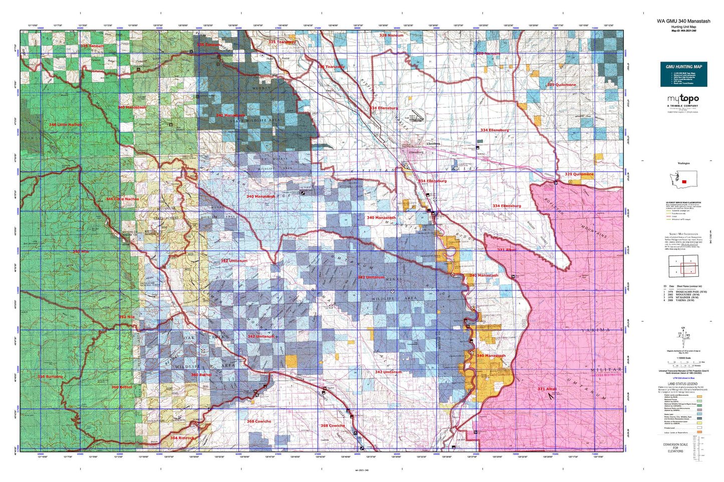
Washington GMU 340 Manastash Map
Couldn't load pickup availability
Hunting unit map of Washington Game Management Unit 340 with topographic lines and unit boundaries. This topo map features UTM / MGRS and Latitude/Longitude grids, plus public land ownership. It comes folded on waterproof paper. Be fully prepared for your hunt with a MyTopo GMU map!.
This map contains the following named places: 98901,98926,98934,98942,Angel Lake,Badger Creek,Badger Pocket,Bald Mountain,Baldy,Barnes Cabin,Bear Lake,Bear Lake Campground,Benton Creek,Benwy Canyon,Bethel Ridge,Black Canyon,Bonlow,Boulder Cave Campground,Boundary Lake,Bull Ditch,Bumping River,Burbank Creek,Burbank Valley,Camp Roganunda,Caribou Creek,Cascade Canal,Catchup Creek,Cheney Ranch,Cherry Creek,Chinook Pass Work Center,Christian Camp,City of Ellensburg,City of Kittitas,City of Tieton,Cleman Mountain,Cliffdell,Clinesmith Irrigation Ditch,Coleman Creek,Cooke Creek,Cottonwood Campground,Cottonwood Creek,Counterfeit Creek,Cowpuncher Ridge,Craigs Hill,Crow Creek,Currier Creek,Davis Trail,Deadhorse Hill,Denmark Hall,Devil Creek,Devil Creek Falls,Devils Slide,Devils Slide Lake,Devils Table,Dry Creek,Dry Meadow,Eagle Rock,Edgar Rock,Edgemont,Ellensburg,Ellensburg Division,Ellensburg Golf Club,Ellensburg Power Canal,Fairview Hall,Fogarty Ditch,Frost Mountain,Frost Mountain Lookout Trail,Glass Creek,Gold Creek,Gold Creek Trail,Goodwin Canyon,Halfway Flat Campground,Hanging Tree Campground,Haystack Rock,Hereford Meadow,High Valley Ranch,Hillside Siding,Holmes,Horse Creek,Horse Ridge,Horseshoe Bend,Horsetail Falls,Hudson Creek,Indian Creek,Jones Creek,Kaner Flat Campground,Kaner Flat Trail,Keenan Meadows Trail,Kelley Hollow,Kelly Ditch,Kittitas,Kittitas Valley,Kiwanis Park,L T Murray State Wildlife Recreation Area,Lady Bug Canyon,Lateral A,Lateral B,Lateral C,Lateral E,Lateral F,Lefthand Fork Rock Creek,Lily Pond Lake,Lindsay Campground,Little Mud Lake,Little Naches Campground,Little Naches River,Little Naches Summer Homes,Little Rattlesnake Creek,Lmuma Creek,Longmire Wenas Canal,Lost Creek,Lost Lake,Lowry Ditch,Lynne Lake,Mal Lake,Manastash Cow Camp,Manastash Creek,Manastash Lake,Manastash Lake Trail,Manastash Lookout,Manastash Ridge Division,McDaniel Lake,McPherson Canyon,Meeks Table,Meeks Table Natural Area,Memorial Park,Mercer Creek,Milk Creek,Milk Lake,Milk Pond,Milk Pond Dam,Milk Pond Picnic Grounds,Mount Aix Vista,Mountain Air Camp,Mountain View Park,Mud Lake,Naches,Naches Ranger Station,Naneum Creek,Nile,Nile Creek,North Fork Gold Creek,North Fork Manastash Creek,North Fork Nile Creek,North Fork Oak Creek,North Fork Rattlesnake Creek,North Fork Wenas Creek,Northwest Yakima Division,Oak Creek,Oak Creek State Wildlife Area,Olmstead Place State Park,Orr Creek,Park Creek,Pine Canyon,Pine Creek,Pinecliff,Quartz Creek,Quartz Creek Trail,Quartz Mountain,Rattlesnake Creek,Rattlesnake Forks,Rattlesnake Guard Station,Rattlesnake Ranger Station,Red Rock,Reecer Creek,Reed Park,Regal,Righthand Fork Rock Creek,Robinson Creek,Rock Creek,Ross Dam,Roza,Roza Creek,Roza Diversion Dam,Sawmill Flat Campground,Schnebly Creek,Scorpion Coulee Creek,Selah Butte,Selah Creek,Selah Valley Canal,Shoestring Lake,Shushuskin Canyon,South Branch Canal,South Branch Extension,South Fork Manastash Creek,South Fork Oak Creek,South Fork Quartz Creek,South Fork Wenas Creek,Spring Canyon,Spring Creek,Spud Canyon,Summit Trail,Swamp Creek,Tamarack Spring Campground,Taneum Ditch,Taneum Lake,Tasker,Tepee Creek,The Cottonwoods,The Island,Thorp,Thrall,Three Creeks,Tieton,Tieton Pond,Tieton River,Tim Ponds,Tjossem Ditch,Tjossem Pond,Tjossem Pond Dam,Town Canal,Town of Naches,Trail Creek,Turbine Ditch,Ty Lake,Umtanum,Umtanum Creek,Wapatox Canal,Wenas,Wenas Camp,Wenas Creek,Wenas Dam,Wenas Lake,Wenas Mammoth Mountain,Wenas Valley Grange,West Side Canal,West Side Park,Whitney Park,Wilson Creek,Windy Point,Windy Point Campground,Wipple Wasteway,Woldale,Wymer,Yellow Jacket Creek