MyTopo
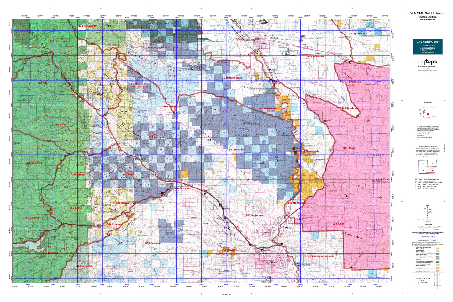
Washington GMU 342 Umtanum Map
Couldn't load pickup availability
Hunting unit map of Washington Game Management Unit 342 with topographic lines and unit boundaries. This topo map features UTM / MGRS and Latitude/Longitude grids, plus public land ownership. It comes folded on waterproof paper. Be fully prepared for your hunt with a MyTopo GMU map!.
This map contains the following named places: 98901,98902,98908,98923,98934,98942,98947,Angel Lake,Badger Creek,Bald Mountain,Baldy,Barnes Cabin,Bear Lake,Bear Lake Campground,Benton Creek,Berglund Lake,Bonlow,Boulder Cave Campground,Boundary Lake,Brace,Buckskin Slough,Bull Ditch,Burbank Creek,Cabin Creek,Camp Roganunda,Caribou Creek,Carlon Park,Cascade Mill Pond,Chalet Mall Shopping Center,Cheney Ranch,Cherry Creek,Chimney Peaks,Chinook Pass Work Center,Christian Camp,City of Kittitas,City of Selah,City of Tieton,Cliffdell,Coleman Creek,Congdon Canal,Cooke Creek,Cottonwood Campground,Cottonwood Creek,Counterfeit Creek,Cowiche,Cowiche Basin,Cowiche Creek,Cowiche Mountain,Davis Trail,Denmark Hall,Devil Creek,Devils Slide Lake,Devils Table,Dobie Orchard,Dry Creek,East Fork Short and Dirty Creek,East Selah,Edgemont,El Kay Farms,Elks Golf and Country Club,Elks Memorial Park,Eschbach,Fish Creek,Fish Lake,Fogarty Ditch,Fruitvale,G and G Orchards,Gilbert Park,Glass Creek,Gleed,Gleed Ditch,Gold Creek,Gold Creek Trail,Goose Egg Mountain,Halfway Flat Campground,Hanging Tree Campground,Hause Creek,Hause Creek Campground,Hillside Siding,Holmes,Holtzinger,Horse Creek,Horseshoe Bend,Hudson Creek,Indian Creek,Indian Flat Campground,Indian Painted Rocks State Park,Johnson Orchards,Kelly Ditch,Kittitas,Kiwanis Park,L T Murray State Wildlife Recreation Area,Lake Myron,Lateral C,Lefthand Fork Rock Creek,Legion Park,Lightning Lake,Lindsay Campground,Little Mud Lake,Little Rattlesnake Creek,Lmuma Creek,Lonesome Cove,Lonesome Cove Campground,Long Lake,Lost Creek,Lost Lake,Lost Lake Campground,Lower Naches Community Park,Lower Naches Grange,Lynne Lake,Mal Lake,Mallett,Manastash Lookout,McDaniel Lake,Meeks Table,Meeks Table Natural Area,Milk Creek,Mill Pond,Miller Park,Milroy Park,Mount Aix Vista,Mountain Air Camp,Mud Flat,Mud Lake,Naches,Naches Heights,Naches Ranger Station,Naches River,Naneum Creek,Nile,Nile Creek,North Fork Cowiche Creek,North Fork Gold Creek,North Fork Manastash Creek,North Fork Nile Creek,North Fork Oak Creek,North Fork Rattlesnake Creek,North Fork Wenas Creek,Northwest Yakima Division,Oak Creek,Oak Creek State Wildlife Area,Olmstead Place State Park,Orr Creek,Palm Park,Park Creek,Peninsula Campground,Pine Creek,Pinecliff,Pleasant Hill,Pomona,Pomona Heights,Pushtay,Ramblers Park,Rattlesnake Creek,Rattlesnake Forks,Rattlesnake Guard Station,Rattlesnake Ranger Station,Reynolds Creek,Righthand Fork Rock Creek,Rimrock,Rimrock Retreat,River Bend Campground,Rock Creek,Rotary Lake,Roza,Roza Creek,Saddle Camp,Salamonia Grange,Sawmill Flat Campground,Scorpion Coulee Creek,Selah,Selah Butte,Selah Creek,Selah Heights,Sentinel Creek,Short and Dirty Creek,Silver Cove Resort,Sleepy Park Meadow,Soup Creek,South Fork Campground,South Fork Cowiche Creek,South Fork Manastash Creek,South Fork Oak Creek,South Fork Tieton River,South Fork Wenas Creek,Spencer Creek,Spring Creek,Stewart,Summit Trail,Swamp Creek,Tasker,Tepee Creek,Terrace Heights,The Cottonwoods,Thrall,Three Creeks,Thunder Creek,Thunder Lake,Tieton,Tieton Basin,Tieton Pond,Tieton Ranger Station,Tieton River,Tieton Work Center,Tim Ponds,Timberwolf Mountain,Tjossem Pond,Town of Naches,Trout Lodge,Twin Bridges,Ty Lake,Umtanum,Umtanum Creek,Viking Village Shopping Center,Washington Park,Weikel,Wenas,Wenas Camp,Wenas Creek,Wenas Lake,Wenas Mammoth Mountain,Wenas Valley Grange,Westpark Shopping Center,Wild Rose Campground,Wildcat Creek,Willows Campground,Wilson Creek,Windy Point Campground,Wixon Park,Wymer,Yakima,Yakima Division,Yakima Mall,Yakima Town and Country Club,Yellow Jacket Creek