MyTopo
Washington GMU 372 Rattlesnake Hills Map
Couldn't load pickup availability
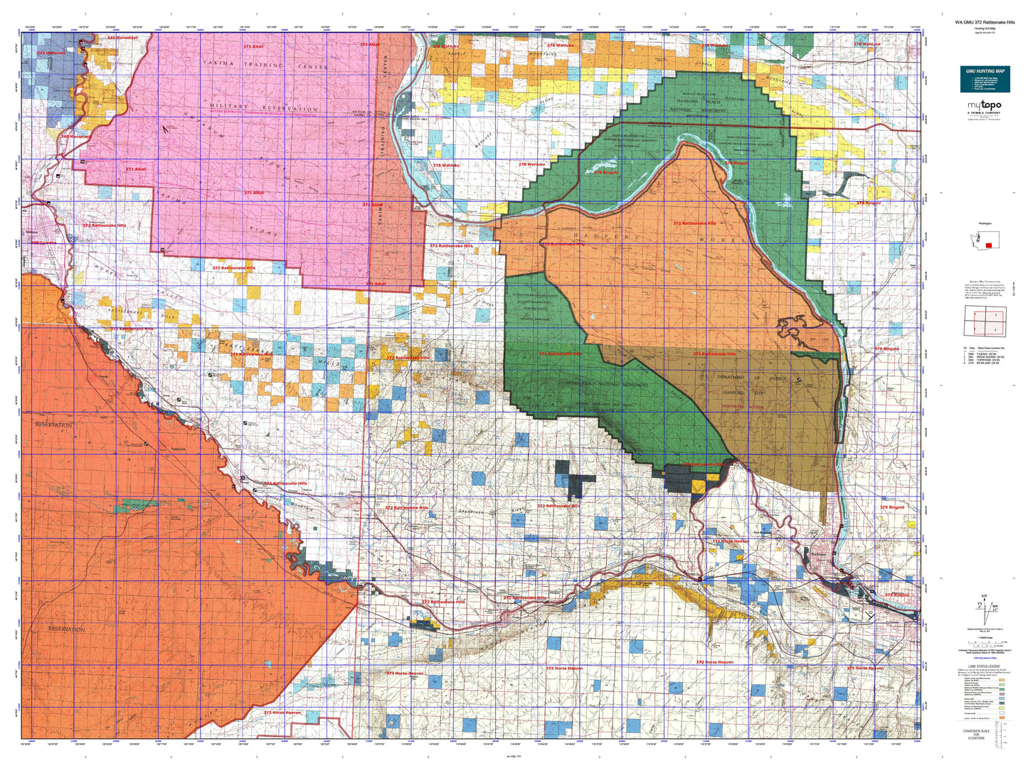
Hunting unit map of Washington Game Management Unit 372 with topographic lines and unit boundaries. This topo map features UTM / MGRS and Latitude/Longitude grids, plus public land ownership. It comes folded on waterproof paper. Be fully prepared for your hunt with a MyTopo GMU map!.
This map contains the following named places: 98901,98921,98930,98932,98935,98936,98938,98944,98948,Airport Ranch,Alfalfa,Allard,Anderson Ranch,Apricot,Artesian,Ashue,Audrey,Badger,Badlands Lakes,Bailie,Bangs Feedlot,Bennett Ranch,Benson Ranch,Benton City,Benton City Division,Benton County,Bernhardt Ranch,Bettie,Beynaud Ranch,Biggam,Birchfield,Blackrock,Blacks Corner,Bos Lake,Bounds Pond,Bridgeman Pond,Buena,Burbank Creek,Byron,Byron Ponds,Cairn Hope Peak,Candy Mountain,Chaffee,Chandler,Chandler Butte,Chandler Power and Pumping Plant,City of Benton City,City of Grandview,City of Granger,City of Mabton,City of Mattawa,City of Moxee,City of Prosser,City of Sunnyside,City of Toppenish,City of Wapato,City of West Richland,City of Zillah,Cockleburr Lake,Coffin Ranch,Cold Creek,Corral Creek,Crewport,Davis Ranch,Desert Aire,Donald,Dry Creek,Eagle Peak,East White Bluffs,Eastway Shopping Center,Edna,Elephant Mountain,Emerald,Emerson Nipple,Empire,Ethel,Farrand Park,Flat Top Hill,Flint,Forsell,Fox Island,Gable Butte,Gable Mountain,Gibbon,Giffin Lake,Ginger,Givens Corner,Goose Egg Hill,Goose Hill,Goose Island,Grandview,Grandview Butte,Grandview Substation,Grandview Water Shed,Granger,Granger Farm Labor Camp,Gravel Pit,Grosscup,Hanford,Hanford Reach National Monument,Hanford Road Barricade,Hanford Site,Hanford Site Division,Hanson Creek,Harrison Hill,Haven,Helen,High Top,Hillside Siding,Hisey Park,Hodges Ranch,Holmes Ranch,Horn Rapids County Park,Horseshoe Lake,Horseshoe Pond,Horsethief Point,Keck,Kinneyville,Kiona,Kisumxi Mountain,Ledbeder Substation,Liberty,Lichty,Locke Island,Lookout,Lost Lake,Lower Valley Golf Club,Mabton,Mabton Division,MacKintosh-Douglas Ranch,Mattawa,May Junction,McBride Slough,McWhorter Ranch,Meeboer Ranch,Midvale,Midway Substation,Monte,Moran Slough,Morgan Lake,Mount Adams Golf and Country Club,Moxee City,Mule Creek,Mule Dry Creek,Nancy,Nass,North Prosser,Northeast Yakima Division,Northwest Benton Division,Oleys Lake,Outlook,Parker Heights Grange,Peanut Hump,Pearl,Pierce,Poisel Butte,Priest Rapids,Priest Rapids Lake,Priest Rapids Wildlife Recreation Area,Prosser,Pump Station Number 10,Pumping Station Number 12,Pumping Station Number 13,Punkin Center,Pushtay,Rattlesnake Creek,Rattlesnake Hills Research Natural Area,Rattlesnake Mountain,Rattlesnake Slope State Wildlife Recreation Area,Red Mountain,Riverland,Roberts Ranch,Round Lake,Royer Hill,Ruth,Saddle Mountain Lake,Saddle Mountain National Wildlife Refuge,Sampson Cabin,Satus,Satus Creek,Satus Longhouse,Satus Number 2 Pumping Station,Satus Number 3 Pumping Station,Sawyer,Selah Butte,Servu,Slaughterhouse Lake,Snake Creek,Snipes Creek,Snipes Mountain,Snively Ranch,Songbird Island,Spring Creek,Stassen Park,Stewart Ranch,Sulphur Creek,Sulphur Creek Ranch,Sunny-Grand Speedway,Sunnyside,Sunnyside Division,Sunnyside State Wildlife Recreation Area,Sunnyside Waterfowl Management Area,Sunnyside Wildlife Recreation Area,Susie,Table Top,Taylor Ranch,Terrace Heights,The Badlands,The Horn,The Island,Toppenish,Toppenish Creek,Toppenish National Wildlife Refuge,Utahco,Wahluke,Wahluke Slope Habitat Management Area,Wanity Slough,Wapato,Warren Lake,Washout,Wesley Junction,West Richland,West Richland Municipal Golf Course,Westside Park,White Bluffs,Whitstran,Willa,Wye Barricade,Wye Radioactive Waste Dump,Yakama Indian Reservation Headquarters,Yakima Sportsmen State Park,Yakima Town and Country Club,Yethonat,Zillah,Zillah Peak