MyTopo
Washington GMU 505 Mossyrock Map
Couldn't load pickup availability
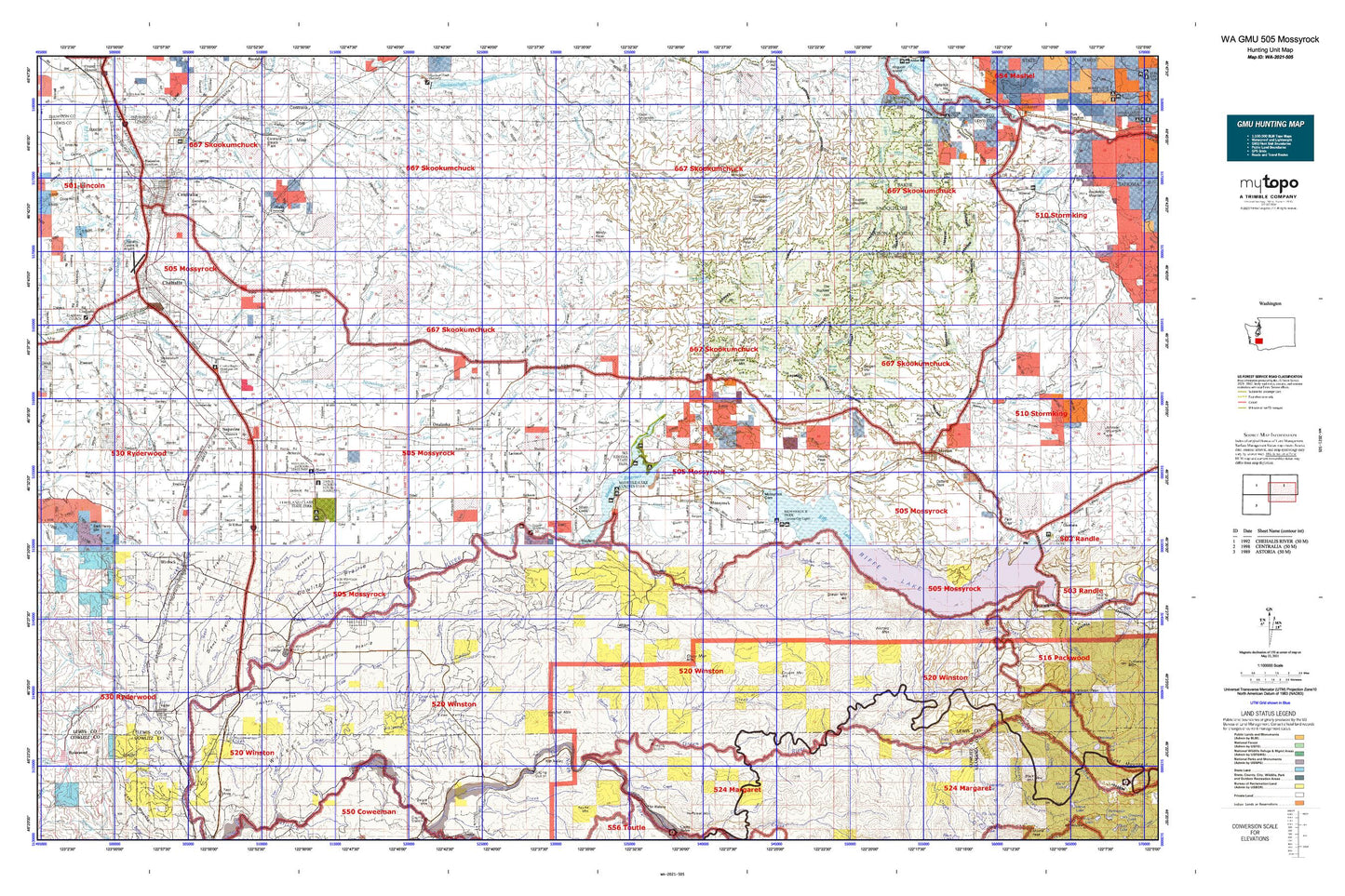
Hunting unit map of Washington Game Management Unit 505 with topographic lines and unit boundaries. This topo map features UTM / MGRS and Latitude/Longitude grids, plus public land ownership. It comes folded on waterproof paper. Be fully prepared for your hunt with a MyTopo GMU map!.
This map contains the following named places: Agren Creek,Airport Lake,Ajlune,Alder Creek,Alexander Creek,Alexander Park,Alpha,Alpine Dairy,Alta Vista,Baker Creek,Bald Mountain,Barnes State Park,Bear Creek,Beaver Creek,Bellicum Peak,Bergen Mountain,Bernier Creek,Berwick Creek,Bigwater Creek,Bill Creek,Blakeslee Junction,Blue Creek,Bremer,Bremer Mountain,Brick Wagner Park,Brights Creek,Brim Creek,Brim Creek School,Bromo Creek,Buck Creek,Camp 10,Camp 9,Carlisle Lake,Cascade Creek,Cedar Creek,Centralia,Centralia College Clock Tower,Centralia Elks Golf Course,Centralia-Chehalis Division,Chehalis,Chehalis Junction,Chehalis Substation,China Creek,Cinebar,Cinnabar Creek,City of Centralia,City of Chehalis,City of Morton,City of Mossyrock,City of Napavine,City of Toledo,City of Vader,City of Winlock,Claquato,Coal Canyon,Coal Creek,Cole Creek,Connelly Creek,Coon Creek,Cottlers Rock,Cougar Creek,Cougar Flat Grange,Cougar Mountain,Cowlitz,Cowlitz Prairie Grange,Cowlitz Trout Hatchery,Coyote Creek,Coyote Mountain,Crazy Man Mountain,Curtis Creek,Deer Creek,Devils Creek,Dillenbaugh Creek,Drop Creek,Duck Lake,Duffy Creek,Eagle Creek,East Fork Tilton River,Elk Creek,Ethel,Ethel Division,Evaline,Fairway Shopping Center,Ferrier Creek,Ferteg Creek,Finn Hill,Fisher Creek,Fly Creek,Fords Prairie,Forest,Fort Borst Lake,Fort Borst Park,Foster Creek,Frase Creek,Goose Lake,Green Mountain,Green River,Green River Salmon Hatchery,Guerrier,Ham Hill,Hanaford Creek,Hard Creek,Harmony,Hatchet Mountain,Hayes Lake,Heller Creek,Henderson Park,Hiawatha Creek,Highland Creek,Hill Creek,Hogan Creek,Hopkey Creek,Hopkins Hill Viewpoint,Horseshoe Lake,Huckleberry Mountain,Huckleberry Mountain Lookout,Hunters Cabin Lookout,Ike Kinswa Campground,Ike Kinswa State Park,Indian Creek,Indian Hole Campground,Jack Welches Creek,Jackson Court House State Park,Jesse Creek,Jim Creek,John Dobson Park,Johnson Creek,Kid Valley,Kid Valley Park,King Creek,Klaus,Kopiah,Lacamas,Lacamas Dairy,Ladd Lookout,Ladd Mountain,Lake Bryant,Layton Prairie School,Lewis and Clark State Park,Lewis County,Little Kentucky,Little Salmon Creek,Logan Hill,Logan Hill Division,Long-Bell Mill Pond,Lookout Peak,Lower Cowlitz School,Lucas Creek Lookout,Marys Corner,Matilda Jackson State Park,Mayfield,Mayfield County Park,Mayfield Lake,McFadden Park,McMurphy Creek,Mendota,Meridian Hill,Mickelsen Dairy,Mill Creek,Mineral Division,Misty Morning Dairy,Morton,Mossyrock,Mossyrock Division,Mossyrock Park,Mossyrock Trout Hatchery,Napavine,Napavine Division,Nesika,Newaukum,Newaukum Hill,Newaukum Lake,Newaukum Lookout,Newaukum Prairie Division,Newaukum River,Newaukum Valley Golf Course,Nineteen Mile Camp,Noble Field,North Fork Brim Creek,North Fork Cedar Creek,Nulls Crossing,Olequa,Olequa Creek,Onalaska,Otter Creek,Oxley,Petite Lake,Phillips,Pikes Hill,Pin Creek,Plummer Lake,Pumphrey Mountain,Recreation Park,Riffe,Riffe Lake,Riverside Golf Course,Riverside Park,Rooster Rock,Saint Urban,Salkum,Salzer Creek,Scammon Creek,Scheuber Drainage Ditch,Seminary Hill,Seminary Hill Natural Area,Shingle Mill,Silver Creek,Silver Creek Ponds,Skook Creek,Snow Creek,South Branch Scammon Creek,Southwest Washington Fairgrounds,Stahl Mountain,Stan Hedwall Park,Stillwater Creek,Stony Grade,Swan Creek,Swofford,Swofford Pond,The Rockies,Toledo,Toledo-Vader Division,Tower,Upper Cowlitz School,Vader,Vader Junction,Wayside School,West Fork Stearns Creek,Wilson,Windy Knob,Windy Knob Lookout,Winlock,Winston,Winston Creek Campground,Winters Mountain