MyTopo
Washington GMU 506 Willapa Hills Map
Couldn't load pickup availability
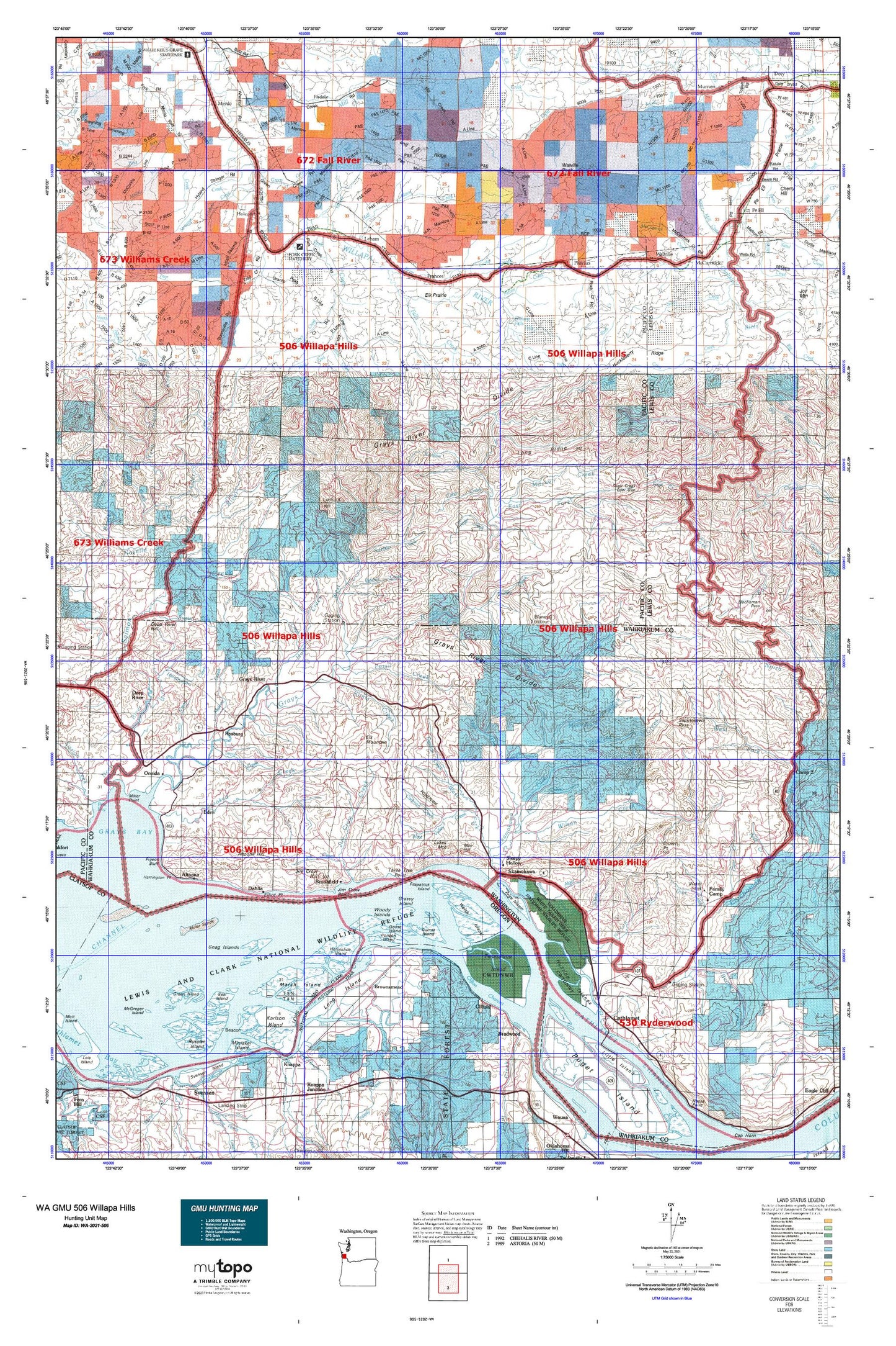
Hunting unit map of Washington Game Management Unit 506 with topographic lines and unit boundaries. This topo map features UTM / MGRS and Latitude/Longitude grids, plus public land ownership. It comes folded on waterproof paper. Be fully prepared for your hunt with a MyTopo GMU map!.
This map contains the following named places: 98572,98612,98621,98643,98647,Alder Creek,Aldrich Point,Aldrich Point Boat Ramp,Alger Creek,Alger Truck Trail,Altoona,Altoona Hill,Beare Hill,Beaver Creek,Beaver Creek State Fish Hatchery,Bell Canyon Creek,Bernie Slough,Big Creek Slough,Birnie Creek,Blaney Creek,Blaney Lookout,Blind Slough,Bradwood,Brookfield,Brookfield Point,Brooks Slough,Brown Creek,Brown Slough,Brownsmead,Brush Island,Cabin Creek,Cadman Creek,Camp Seven Pond,Cannery Light,Cannonball Creek,Carlson Landing,Cathlamet,Cathlamet City Park,Cathlamet Division,Cathlamet Recreational Vehicle Park,Cathlamet Wastewater Treatment Plant,Clear Creek,Clifton,Columbian White-Tailed Deer National Wildlife Refuge,Cougar Creek Reservoir,Crim Creek,Crooked Creek,Custer Creek,Dahlia,Deep River,Deep River Hill,Deer Creek,Devils Elbow,Duck Creek,Duncan Slough,East Cathlamet,East Fork Chehalis River,East Fork Grays River,Eden,Eggman Creek,Eight Creek,Elk Mountain,Elliott Point,Ellis Creek,Ellison Slough,Elochman Slough Marina,Elochoman Hatchery,Elochoman River,Elochoman Slough,Empi Creek,Falk Creek,Fall Creek,Falls Creek,Family Camp,Fern Creek,Fink Creek,Firdale,Fitzpatrick Island,Fork Creek,Forks Creek Hatchery,Fossil Creek,Frances,Globe,Gnat Creek,Goose Island,Grassy Island,Grays River,Grays River Division,Grays River Salmon Pond,Grays River State Fish Hatchery,Green Creek,Green Island,Grizzly Slough,Half Moon Creek,Harlows Creek,Harper,Harrington Point,Heldt Creek,Hendrickson Creek,Highland Creek,Hitchcock Creek,Hogans Hill,Holcomb,Honey Creek,Horseshoe Island,Hull Creek,Hull Creek Lookout,Hunt Creek,Hunting Islands,Hunts Mill Point,Indian Jack Slough,Indian Village Mobile Home Park,Jim Crow Sands,Johnson Creek,Johnson Ranch,Julia Butler Hansen Refuge for the Columbian White-tailed Deer,Karlson Island,Kelly Creek,Kessel Creek,King Creek,Klints Creek,KM Mountain,Lebam,Left Fork Skamokawa Creek,Lester Creek,Lester Creek Reservoir,Lewis and Clark National Wildlife Refuge,Little East Fork Naselle River,Long Island,Longtain Creek,Lutes Mountain,Mahaffey Creek,Malone Creek,Marsh Island,McCormick,McCormick Creek,McDonald Creek,McGregor Island,Menlo,Middle Fork Rue Creek,Miller Sands,Minaker Island,Mitchell Creek,Moe Hill,Murnen,Murphys Hole,Nallpee,Nelson Creek,Nikka Creek,Nine Creek,Noe Creek,North Fork South Fork Crooked Creek,North Island,North Naselle River,Oneida,Oxbow Creek,Parsons,Patton Creek,Pe Ell,Penny Creek,Person Creek,Pete Anders Slough,Pillar Rock Island,Pillar Rock Lower Range,Pillar Rock Upper Range,Pluvius,Pluvius Hill,Pollard Creek,Price Island,Puget Bar,Puget Island Range,Quarry Creek,Quinns Island,Rangila Hill,Reynolds,Risk Creek,Robinson Creek,Rock Creek,Rosburg,Russian Creek,Ryan Island,Sage Creek,Salmon Creek,Seal Creek,Seal Island,Seal Slough,Seven Creek,Shannon Creek,Shields Creek,Silver Creek,Skamokawa,Skamokawa Channel,Skamokawa Creek,Skamokawa Division,Skamokawa Truck Trail,Skamokawa Vista Park,Sleepy Hollow,Smith Creek,Snag Islands,South Creek,South Fork Crooked Creek,South Fork Grays River,Spear Creek,Squally Jim,Standard Creek,State Camp,Steamboat Slough,Stowe Creek,Stringer Creek,Sutico,Sweigiler Creek,Tenasillahe Island,Thadbar Creek,Thrash Creek,Three Tree Point,Town of Cathlamet,Town of Pe Ell,Trap Creek,Tronson Island,Wahkiakum County,Wahkiakum County Fairgrounds,Walker Creek,Walville,Walville Peak,Water Mill Creek,Welch Island,West Fork Chehalis River,West Fork Ellis Creek,West Fork Grays River,West Fork Rue Creek,West Fork Skamokawa Creek,West Valley Creek,Willapa Valley Division,Wilson Creek,Woody Island