MyTopo
Washington GMU 530 Ryderwood Map
Couldn't load pickup availability
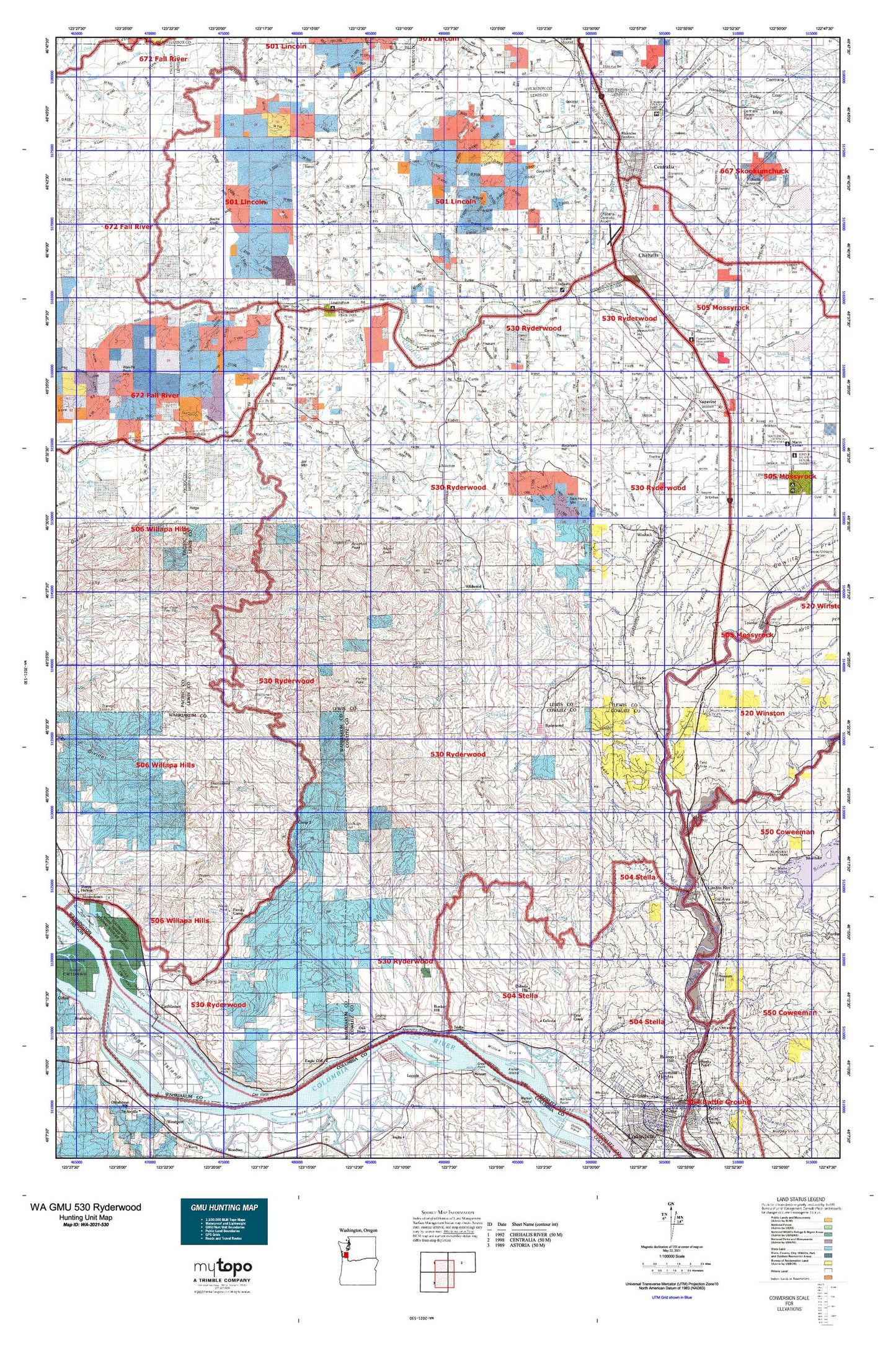
Hunting unit map of Washington Game Management Unit 530 with topographic lines and unit boundaries. This topo map features UTM / MGRS and Latitude/Longitude grids, plus public land ownership. It comes folded on waterproof paper. Be fully prepared for your hunt with a MyTopo GMU map!.
This map contains the following named places: Abe Creek,Abernathy Fish Technology Center,Abernathy Mountain,Abernathy Point,Absher Creek,Adna,Agren Creek,Airport Lake,Alder Bluff,Alder Creek,Alexander Park,Arkansas Creek,Banks Creek,Barnes Forest Corridor,Barnes State Park,Barney Creek,Baxter Creek,Bear Creek,Beaver Creek,Beaver Creek State Fish Hatchery,Bebe Mountain,Becker Creek,Berwick Creek,Big Creek,Big Roger Creek,Black Creek,Blakeslee Junction,Boistfort,Boistfort Park,Boistfort Peak,Boistfort Peak Lookout,Brick Wagner Park,Brim Creek,Brim Creek School,Browns Creek,Buckhorn Hill,Bucks Knob,Bull Pen Creek,Bunker,Bunker Creek,Bunker Division,Bunker Hill,Byron Creek,Cameron Creek,Camp 2,Camp McDonald,Campbell Creek,Cannonball Creek,Capps Creek,Carson Creek,Castle Rock,Castle Rock Division,Castle Rock Fairgrounds,Cathlamet,Cathlamet City Park,Cathlamet Division,Cathlamet Recreational Vehicle Park,Cathlamet Wastewater Treatment Plant,Cedar Creek,Cedar Gates,Centralia,Centralia College Clock Tower,Centralia Elks Golf Course,Centralia-Chehalis Division,Ceres,Ceres Hill,Chehalis,Chehalis Junction,Chehalis Substation,Cherry Hill,China Creek,Cinnabar Creek,City of Castle Rock,City of Centralia,City of Chehalis,City of Napavine,City of Vader,City of Winlock,Claquato,Clear Creek,Clinton Knob,Coal Creek,Coal Creek Slough,Cook Hill,Coon Creek,Cougar Creek Reservoir,Cougar Flat Grange,Crego,Crego Grange,Crego Hill,Curtis,Curtis Creek,Davis Hill,Deep Creek,Deer Creek,Delameter Creek,Dell Creek,Dillenbaugh Creek,Dobson Creek,Doty,Dryad,Duck Creek,Duffy Creek,Dunn Creek,Eagle Creek,East Cathlamet,East Fork Chehalis River,East Fork Coal Creek,East Fork Elochoman River,Eight Creek,Elk Creek,Elochman Slough Marina,Elochoman Hatchery,Elochoman Lake,Eufaula,Eufaula Heights,Evaline,Evergreen Terrace,Fairway Shopping Center,Fall Creek,Family Camp,Fayette,Ferrier Creek,Ferrier Peak,Finn Hill,Foran,Fords Prairie,Fort Borst Lake,Fort Borst Park,Foster Creek,Fronia Creek,Gabel Creek,Galvin,Gardner,Garret Creek,George Creek,Germany Creek,Gull Island,Halfway Creek,Halsea Creek,Ham Hill,Harper,Hay Mountain,Hayes Lake,Helmicks Pond,Henderson Park,Hilda,Hill Creek,Hogan Creek,Hope Creek,Horseshoe Lake,Hull Creek,Incline Lookout,Indian Village Mobile Home Park,John Creek,John Dobson Park,Jones Creek,Joy Mountain,Katula Creek,Keller Creek,Kesting Dairy,King Creek,Klaber,Kowalski Creek,Lake Creek,Laughlin Creek,Lentz Creek,Lester Creek Reservoir,Lexington,Lincoln Creek Grange,Littell,Little Island,Little Mountain,Little Onion,Mays,McCormick,McFadden Park,Meskill,Mickelsen Dairy,Millburn,Murnen,Napavine,Napavine Division,Newaukum,Newaukum Hill,Newaukum Prairie Division,Newaukum Valley Golf Course,Noble Field,Nulls Crossing,Oak Point,Ogden Hill,Olequa,Ostrander,Oxley,Pe Ell,Pikes Hill,Pleasant Hill,Plummer Lake,Point Hill,Pumphrey Mountain,Rainbow Falls State Park,Recreation Park,Reynolds,Riverside County Park,Riverside Golf Course,Riverside Park,Round Knob,Ruth,Ryderwood,Ryderwood Pond,Saint Urban,Sam Henry Mountain,Sandy Bend,Seminary Hill,Seminary Hill Natural Area,Skamokawa Division,Southwest Washington Fairgrounds,Stan Hedwall Park,State Camp,Stella,Stony Grade,Sure Shot Mountain,Surge Pond,Toledo-Vader Division,Town of Cathlamet,Town of Pe Ell,Tucker,Vader,Vader Junction,Wabash,Wabash Junction,Walville,Wildwood,Winlock,Winlock-Pe Ell Division