MyTopo
Washington GMU 550 Coweeman Map
Couldn't load pickup availability
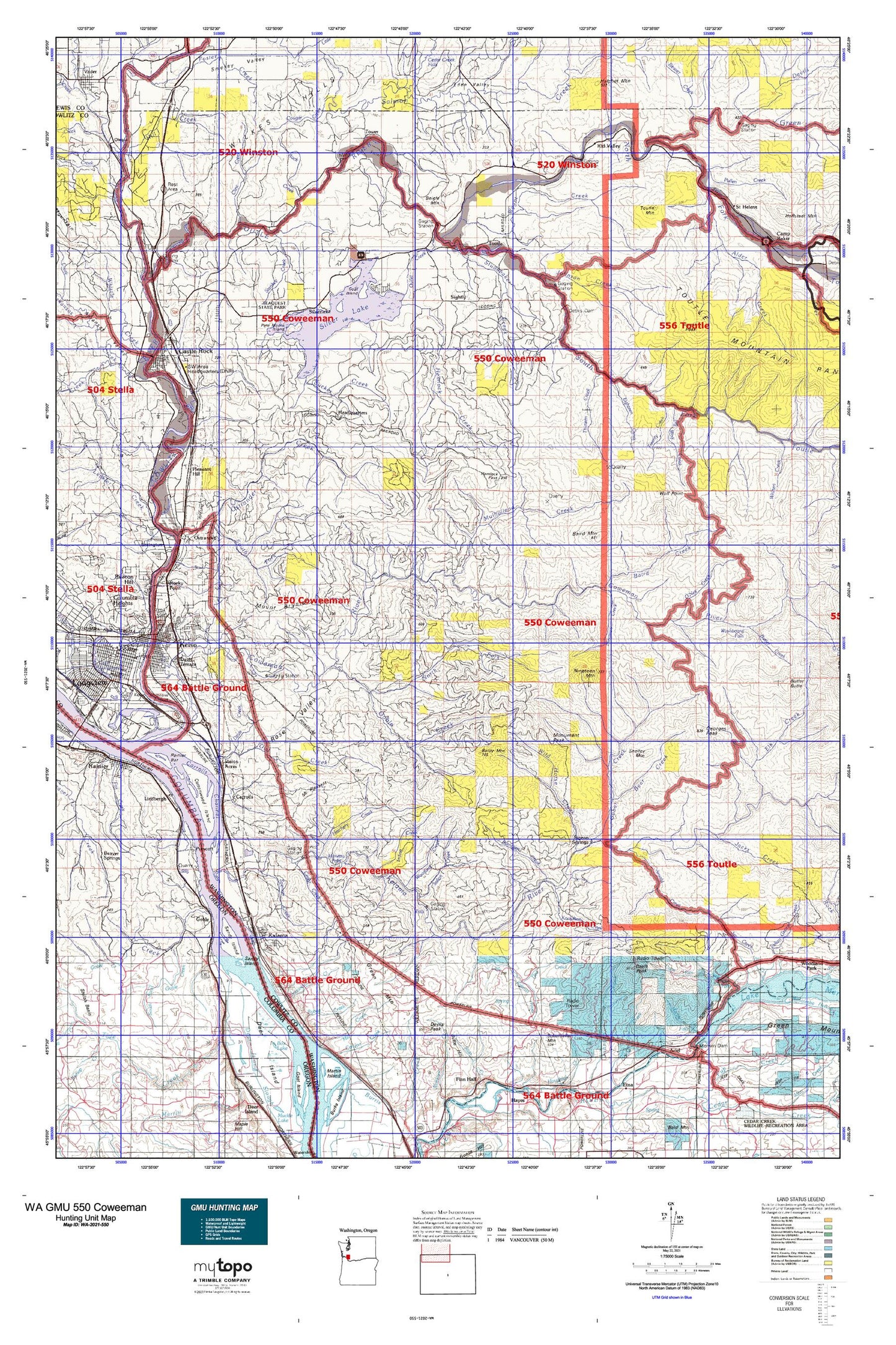
Hunting unit map of Washington Game Management Unit 550 with topographic lines and unit boundaries. This topo map features UTM / MGRS and Latitude/Longitude grids, plus public land ownership. It comes folded on waterproof paper. Be fully prepared for your hunt with a MyTopo GMU map!.
This map contains the following named places: 98611,98625,98626,98645,98649,Adams Creek,Ahle Point,Al Raught Park,Alder Creek,Alder Creek Rearing Pond,Arkansas Creek,Arnold Creek,Baird Creek,Baird Mountain,Baldy Mountain,Barnes Forest Corridor,Battle Mountain,Bear Creek,Beaver Creek,Beigle Mountain,Big Wolf Creek,Blackman Creek,Box Lake,Brown Creek,Brownell Creek,Butler Creek,Bybee Creek,Bybee Ledge Channel,Camp Coweeman,Camp Cowlitz,Camp Kalama,Cape Horn Creek,Carr Slough,Carrolls,Carrolls Channel,Carrolls Hill,Castle Rock,Castle Rock Fairgrounds,Cedar Creek,Charlton,City of Castle Rock,City of Kalama,City of Kelso,City of Prescott,Cline Creek,Cloverdale,Coal Mine Creek,Coffin Rock,Conradi Lake,Conradi Lake Dam,Cottonwood Beach,Cottonwood Island,Cottonwood Island Turn,Cottonwood Island Upper Range,Cottonwood Lake,Cougar Creek,Coweeman Ranger Station,Coweeman River,Coweman Gravel Pit Number One Dam,Coweman Gravel Pit Number Two Dam,Cowlitz County,Cowlitz River,Daves Slough,Davis Creek,Davis Peak,Davis Terrace,Day Creek,Dee Creek,Deer Island Point,Deer Island Slough,Devils Creek,Devils Peak,Drays Mound,Eighteen Creek,Elder Rocks,Foster Creek,Gardner,Georges Peak,Georges Peak Trail,Gilles Shopping Center,Goat Island,Gobar Creek,Goble,Goble Beach,Goble Creek,Goble Mountain,Green River,Green River Salmon Hatchery,Harding Creek,Hatchery Creek,Hatchet Mountain,Headquarters,Hemlock Creek,Highland Park,Hill Creek,Hoffman Landing,Hoffstadt Creek,Hoffstadt Creek Park,Horseshoe Bend,Hunter Bar,Indian Creek,Indian Island,Italian Creek,Jack Falls,Jacks Creek,Jacobson Reid Lumber Company,Jim Creek,Jim Watson Creek,Johnson Creek,Jordan Creek,Kalama,Kalama Division,Kalama Falls Salmon Hatchery,Kalama Lower Range,Kalama River,Kalama Upper Range,Kelso,Kid Valley,Kid Valley Park,Knowlton Creek,Laurel Beach County Park,Leckler Creek,Lexington,Lindbergh,Little Baird Creek,Little Jack Falls,Little Kalama River,Little Kentucky,Longview Junction,Lost Creek,Lower Kalama River Falls,Marble Creek,Marietta Creek,Marietta Falls,Martin Creek,Meridian Lookout,Meridian Mountain,Monument Peak,Mount Brynion,Mount Pleasant,Mulholland Creek,Neer City,Neer Creek,Nehalem Junction,Nineteen Creek,Nineteen Mile Camp,Nineteen Mountain,Noble Creek,North Fork Goble Creek,North Fork Toutle River,Nye Creek,Oasis,Oasis Creek,O'Neil Creek,Ostrander,Ostrander Creek,Outlet Creek,Owl Creek,Pete Moore Island,Piedmont Creek,Pigeon Springs,Pleasant Hill,Port of Kalama Marina,Portland General Electric Trojan Park,Prescott,Prescott Bar,Prescott Beach County Park,Pruitt Reservoir,Pullen Creek,Rainier Bar,Reid Mountain,Reuben,Riverside County Park,Rock Creek,Rocky Point,Rose Valley,Rose Valley Division,Ross Peak,Saint Helens,Salmon Creek,Sam Smith Creek,Sandy Bend,Sandy Bend Creek,Sandy Island,Schoolhouse Creek,Schumaker Mountain,Scipio's Goble Landing,Scipio's Goble Landing Boat Launch,Seaquest State Park,Shell Oil Company Spur,Shelley Mountain,Sightly,Signal Peak,Silver Lake,Silver Lake Dam,Skipper Creek,Smith Mountain,South Fork Goble Creek,South Fork Ostrander Creek,South Fork Toutle Debris Dam,South Fork Toutle River,Spencer Creek,Stankey Creek,Stitz Creek,Studebaker Creek,Sucker Creek,Summers Creek,Swan Lake,Terrace,Thirteen Creek,Three Rivers Mall,Tide Creek,Timber Point,Toutle,Toutle Mountain,Toutle Mountain Range,Toutle River,Tower,Trojan,Trojan Nuclear Plant,Tucker,Turner Creek,Twenty Creek,Vision Acres,Waldon Island,Washboard Falls,Welter Creek,Whittle Creek,Wild Horse Creek,Wild Horse Peak,Wilkes Hills,Wolf Point,Woolford Creek,Woolford Mountain,Wyant Creek