MyTopo
Washington GMU 603 Pysht Map
Couldn't load pickup availability
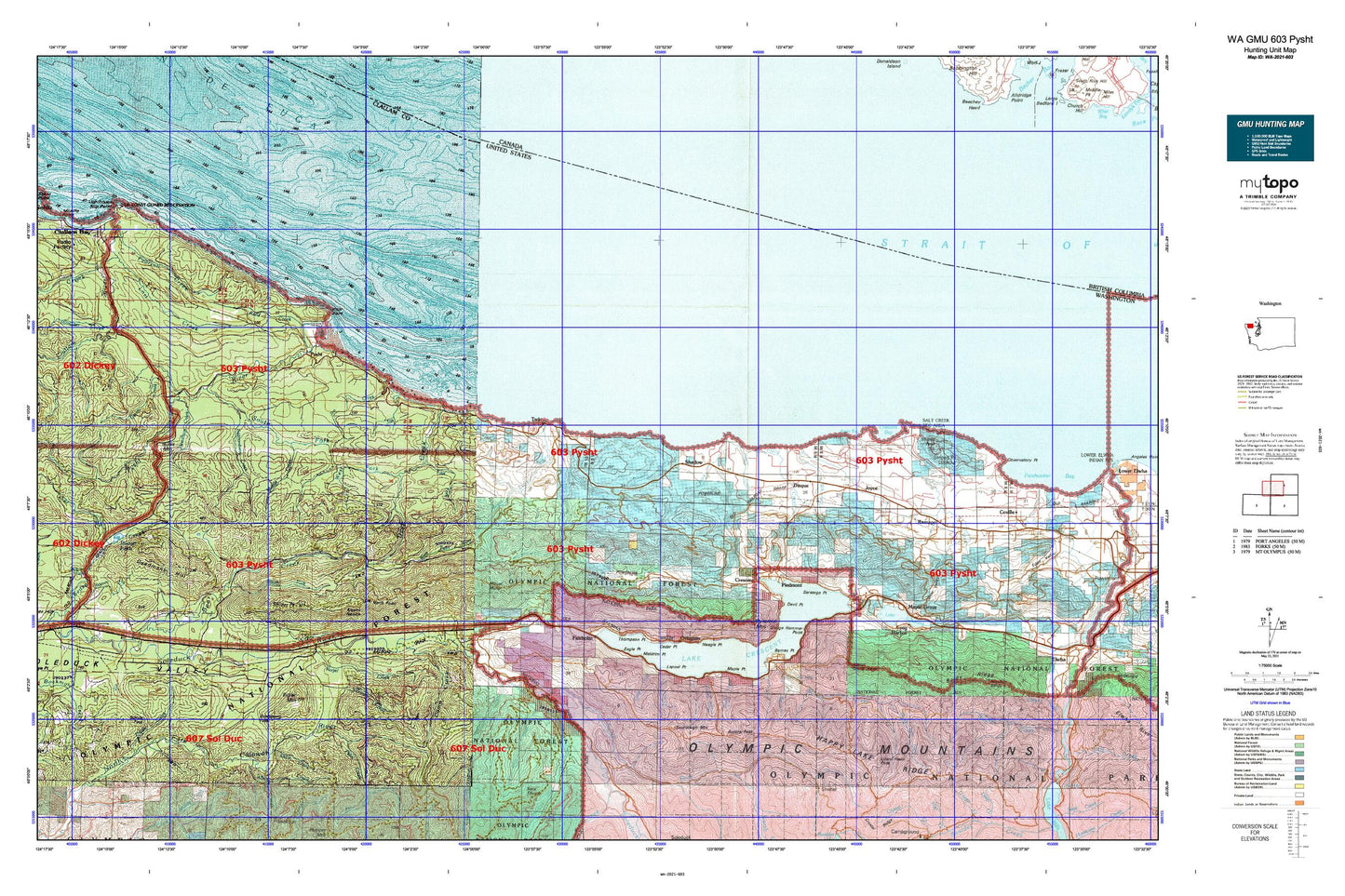
Hunting unit map of Washington Game Management Unit 603 with topographic lines and unit boundaries. This topo map features UTM / MGRS and Latitude/Longitude grids, plus public land ownership. It comes folded on waterproof paper. Be fully prepared for your hunt with a MyTopo GMU map!.
This map contains the following named places: 98363,Agate Bay,Albion Creek,Aurora Creek,Aurora Peak,Aurora Trail,Balch Bridge,Baldy Ridge,Barnes Creek,Barnes Point,Barnes Point Picnic Area,Bear Creek,Bear Creek Campground,Bear Springs Rearing Pond,Bear Valley,Beaver Lake,Bigler Mountain,Blowder Creek,Bonidu Creek,Boundary Creek,Burnt Mountain,Butler Cove,Butler Creek,Camp Creek,Canyon Creek,Cedar Point,Clallam Bay Spit,Clallam County,Clallam County Fire District 2 Station 24 - Shadow Mountain,Clallam County Fire District 4,Cole Creek,Crescent,Crescent Bay,Crescent Division,Crescent Rock,Crescent School,Cross Creek,Deadmans Hill,Deep Creek,Deep Creek Guard Station,Devil Point,Devils Creek,Disque,Eagle Creek,Eagle Lakes,Eagle Point,East Beach,East Beach Picnic Area,East Fork Deep Creek,East Twin River,Evergreen Lookout,Fairholme,Fairholme Campground,Fairholme Ranger Station,Falls Creek,Field Creek,Floe Quarry,Gettysburg,Gettysburg Ranch,Gibson Farm,Goodman Creek,Green Creek,Grindstone Pass,Hanna Creek,Happy Lake,Happy Lake Creek,Happy Lake Ridge,Harrigan Point,Indian Creek,Jim Creek,Joe Creek,Joyce,Joyce Bible Church,Joyce Post Office,June Creek,Klahowa Campground,Kloshe Nanitch,Kloshe Nanitch Lookout,Kugel Creek,La Poel Picnic Area,Lake Crescent,Lake Crescent Ranger Station,Lake Sutherland,Lapoel Creek,Lapoel Point,Littleton Creek,Lizard Head Peak,Low Point,Lyre River,Lyre River Campground,Maple Grove,Maple Point,Marymere Falls,Meldrim Point,Middle Creek,Mount Muller,Mount Storm King,Murdock Creek,Neagle Point,Needham Creek,Nelson Creek,North Fork Sol Duc River,North Fork Soleduck River Trail,North Point,North Point Lookout,North Shore Picnic Area,Ovington,Pearson Creek,Piedmont,Pillar Point,Pillar Point Recreation Area,Pistol Creek,Port Crescent,Pyramid Mountain,Pyramid Mountain Trail,Pysht,Pysht Millpond,Pysht River,Ramapo,Reed Creek,Rosemary,Sadie Creek,Salmonberry Creek,Salt Creek,Salt Creek Campground,Salt Creek Recreation Area,Saratoga Point,Schutz Pass,Shadow,Shadow Mountain Recreational Vehicle Park,Short Creek,Singers,Sledge Hammer Point,Slip Point Lighthouse,Smith Creek,Snider Creek,Snider Forest Service Station,Snider Peak,Snug Harbor,Soleduck Ranger District,Sourdough Mountain,South Fork Bear Creek,South Fork Pysht River,South Fork Sol Duc River,Striped Peak,Susie Creek,Thompson Point,Tom Creek,Tongue Point,Trail Creek,Tree Bluff,Twin,West Fork Albion Creek,West Fork Deep Creek,West Twin River,Whiskey Creek,Wye Creek