MyTopo
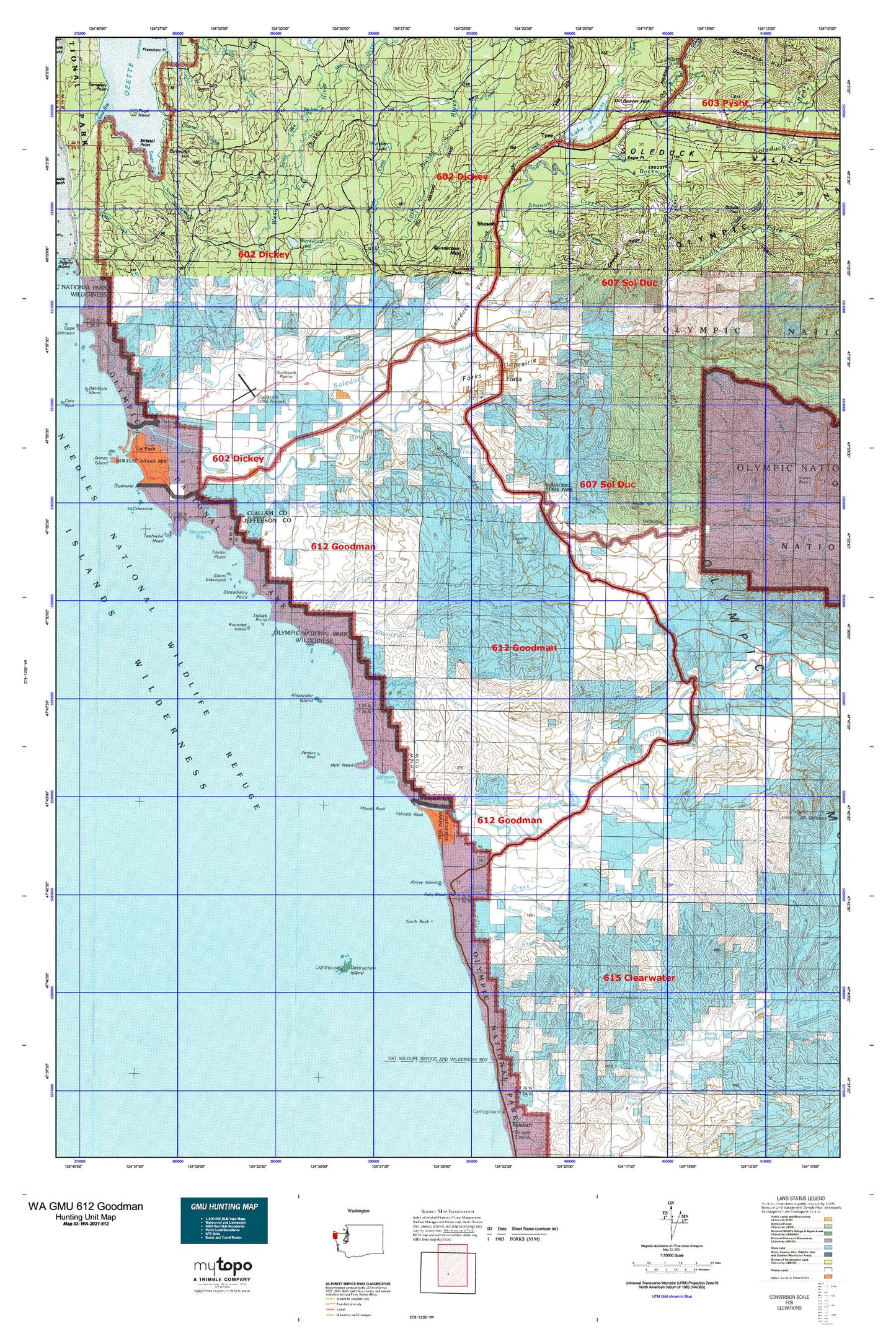
Washington GMU 612 Goodman Map
Couldn't load pickup availability
Hunting unit map of Washington Game Management Unit 612 with topographic lines and unit boundaries. This topo map features UTM / MGRS and Latitude/Longitude grids, plus public land ownership. It comes folded on waterproof paper. Be fully prepared for your hunt with a MyTopo GMU map!.
This map contains the following named places: 98305,Abbey Island,Alder Creek,Alder Grove Mobile Home Park,Alexander Island,Anderson Creek,Anderson Ridge,Assembly of God Church,Beach Trail 5,Beach Trail 6,Beach Trail 7,Bear Creek,Bear Creek Campground,Bear Springs Rearing Pond,Beaver,Beaver Creek,Beaver Fire Department,Beaver Hill,Beaver Post Office,Beaver Prairie,Beaver Sand and Gravel Quarry,Beaver School,Big Joes Lake,Birkestol Hill,Bockman Creek,Bogachiel,Bogachiel River,Bogachiel State Park,Bogachiel Trail,Boulder Beach,Braden Creek,Calawah Ridge,Calawah River,Calawah River Bridge,Calvary Chapel Forks,Campbell Quarry,Cassel Creek,Cassel School,Cedar Creek,Christmas Creek,Church of the Nazarene,City of Forks,Coal Creek,Colby Creek,Congregational Church,Coon Creek,Cottonwood Campground,Department of Natural Resources Heliport,Destruction Island,Destruction Island Lighthouse,Destruction Island Viewpoint,Devils Creek,Diamond Rock,Dickey Camp,District Run Home School,Dowans Creek,Dry Creek,Eagle Point,East Fork Dickey River,East Fork Hell Roaring Creek,East Fork Miller Creek,Eaton Creek,Elk Creek,Elk Creek Mobile Home Park,Elk Ridge,Fahnestock Creek,Falls Creek,First Baptist Church,First Congregational Church,Fletcher Cemetery,Fletcher Creek,Forks,Forks Airport,Forks Alternative School,Forks Ambulance Service,Forks Bible Church,Forks Cemetery,Forks City Hall,Forks Community Hospital,Forks Dam,Forks Division,Forks Elementary School,Forks High School,Forks Junior High School,Forks Library,Forks Middle School,Forks Mobile Home Park,Forks Police Department,Forks Post Office,Forks Prairie,Forks Ranger Station,Forks Seventh Day Adventist Church,Forks Seventh Day Adventist School,Forks Timber Museum,Forks Transit Center,Forks Wastewater Treatment Plant,Fossil Creek,Franklin Creek,Giants Graveyard,Goodman Creek,Grader Creek,Grader Creek Hill,Gunderson Creek,Gunderson Mountain,Gunderson Pass,Hell Roaring Creek,Hemp Hill Creek,Hoh,Hoh Head,Hoh Indian Reservation,Hoh Ox Bow Campground,Hoh River,Hoh River Bridge,Hyas Creek,Jackson Creek,James Park,James Pond,Jefferson Cove,Jefferson Oil Seep,Kahkwa Creek,Kalaloch Ridge,Kingdom Hall of Jehovahs Witnesses,Klahanie Campground,KLLM-FM (Forks),KVAC-AM (Forks),Lacy Oil Seep,Lagitos Hill,Lake Creek,Lake Pleasant,Lake Pleasant Boat Launch Ramp,Lake Pleasant Mobile Home,Lake Pleasant Recreation Area,Lake Pleasant Recreational Vehicle Park,Larger Creek,Leyendecker Boat Ramp,Leyendecker Picnic Area,Little Quillayute Prairie,Loop Tavern Quarry,Lost Creek,Lower Hoh Fire Camp,Marietta Mobile Home Court,Mary Clark Quarry,Maxfield Creek,Maxfield Prairie,May Creek,Middle Fork Dickey River,Middle Rock,Mill Creek,Miller Creek,Minter Creek,Mora,Mora Campground,Mora Ranger Station,Morganroth Creek,Mosquito Creek,Muralts Mobile Home Park,Murphy Creek,Naval Auxiliary Air Station Quillayute,Newbert Creek,Nolan Creek,North Fork Calawah River,North Fork Mosquito Creek,North Rock,Oil City,Old Smokey Pit,Pacific Ranger District - Forks Office,Perkins Reef,Pins,Pins Creek,Prince of Peace Lutheran Church,Quileute Reservation,Quillayute,Quillayute Airport,Quillayute Needles National Wildlife Refuge,Quillayute Prairie,Quillayute Prairie Cemetery,Quillayute Quarry,Quillayute Valley School District 402 Office,Rain Forest Mobile Home Park,Rainey Creek,Reade Hill,Ripple Creek,Rocky Rapids,Rounded Island,Ruby Beach,Saint Anne's Church,Sand Creek,Sappho,Sappho Quarry,Schutz Pass,Scott Creek,Scotts Bluff,Shuwah,Shuwah Creek,Sitkum River,Siwash Creek,Skookumchuck Rapids,Skunk Creek,Snell Creek,Sol Duc River,Sol Duc Valley,Soleduck Salmon Hatchery,South Fork Calawah River,South Fork Cedar Creek,South Fork Maxfield Creek,South Rock,Squaw Creek,Steamboat Creek,Strawberry Bay,Strawberry Point,Tassel Creek,Taylor Point,Teahwhit Head,The Church of Jesus Christ of Latter Day Saints,Three D Beach,Thunder Creek,Thunder Field,Thunder Lake,Tilicum Park,Toleak Point,Tumbling Rapids Recreation Area,Tyee Prairie,Undi Lake,Upper Cool Creek,Wasankaris Mobile Home Park,Weeden Creek,Wentworth Lake,West Fork Dickey River,Whitcomb Dimmel Pit,Willow Place Mobile Home Park,Wilson Ranch,Winfield Creek


