MyTopo
Washington GMU 618 Matheny Map
Couldn't load pickup availability
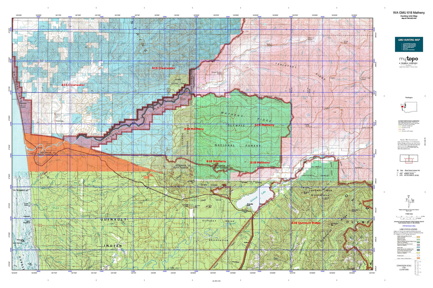
Hunting unit map of Washington Game Management Unit 618 with topographic lines and unit boundaries. This topo map features UTM / MGRS and Latitude/Longitude grids, plus public land ownership. It comes folded on waterproof paper. Be fully prepared for your hunt with a MyTopo GMU map!.
This map contains the following named places: 98526,98575,Amanda Park,Amanda Park Census Designated Place,Amanda Park Post Office,Amanda Park Regional Library,Barker Rapids,Bell Mountain,Big Creek,Boulder Creek,Bull Creek,Camp Creek,Canoe Creek,Cedar Creek,Christmas Creek,Clearwater,Clearwater River,Clearwater State Park,Coal Creek,Copper Mine Botton Campground,Cougar Creek,Crane Creek,Crooks Creek,Crooks Rapids,Deception Creek,Dry Creek,East Fork Miller Creek,East Fork Tacoma Creek,Elk Creek,Elk Creek Lookout,Elkhorn Creek,Falls Creek,Falls Creek Forest Camp,Falls Creek Work Center,Finley Creek,Finley Peak Lookout,Fisher Creek,Fisher Rapids,Gatton Creek,Gatton Creek Campground,Grandey Creek,Grays Harbor Fire District 4 Lake Quinault Volunteer Fire Department,Grays Harbor Fire District 4 Lake Quinault Volunteer Fire Department Neilton,Haas Creek,Harlow Creek,Hibbard Creek,Higley Creek,Higley Peak,Higley Trail,Hogsback,Hoh Creek,Hook Branch Creek,Huckleberry Creek,Hunt Creek,Hurst Creek,Indian Affairs Forestry Station,Inner Creek,Jefferson County Sheriff's Office Forks Substation,July Creek,July Creek Campground,Kerr Creek,Kestner Creek,Kloochman Rock,Kloochman Rock Lookout,Knorr Creek,Lake Dilly,Lake Quinault,Lake Quinault Elementary School,Lake Quinault High - Junior High School,Lake Quinault High School,Lake Quinault Historical Society and Museum,Lilly Lake,Lone Mountain,Lunch Creek,Lyman Rapids,Manor Creek,Matheny Creek,Matheny Ridge,McCalla Creek,McCormick Creek,McKinnon Creek,Meadow Creek,Merriman Creek,Middle Fork Salmon River,Milbourn Creek,Miller Creek,Mink Creek,Moses Creek,Moses Prairie,Mount O'Neil,Mud Creek,Neilton,Neilton Census Designated Place,Neilton Post Office,North Fork Manor Creek,North Fork Raft River,North Fork Salmon River,Norwood,O'Took Prairie,Our Lady - Olympics Catholic Church,Pacific Ranger District - Quinault Office,Parson Rapids,Peterson Creek,Phelan Creek,Pope Lake,Prairie Creek,Pratt Cliff,Preacher Rapids,Queets,Queets - Clearwater Elementary School,Queets Campground,Queets Census Designated Place,Queets Corridor,Queets Ranger Station,Quinault,Quinault Lake School District 97 Office,Quinault Post Office,Quinault Ranger District,Quinault Ranger Station,Quinault Recreation Area,Quinault Research Natural Area,Quinault Reservation,Quinault Reservation Division,Quinault Valley Chapel,Raft River,Rainy Creek,Red Creek,Rocky Rapids,Round Lake,Salmon River,Sams Rapids,Sams Ridge,Sams River,Shale Creek,Skookumchuck Rapids,Slide Creek,Smith Place,Snahapish River,South Fork Boulder Creek,South Fork Manor Creek,South Fork Raft River,South Fork Salmon River,Spruce Bottom Shelter,State Log Scaling Station,Stequaleho Creek,Swede Creek,Tacoma Creek,Taholah High School,Ten O'Clock Creek,Thimble Mountain,Trail Creek,Tshletshy Creek,Upper Clearwater Campground,Waring Creek,Wildcat Creek,Willaby Creek,Willaby Creek Forest Camp,Willamaud Creek,Wolf Creek,Wooded Peak,Wright Canyon,Yahoo Lake,Yahoo Lake Campground,Ziegler Creek