MyTopo
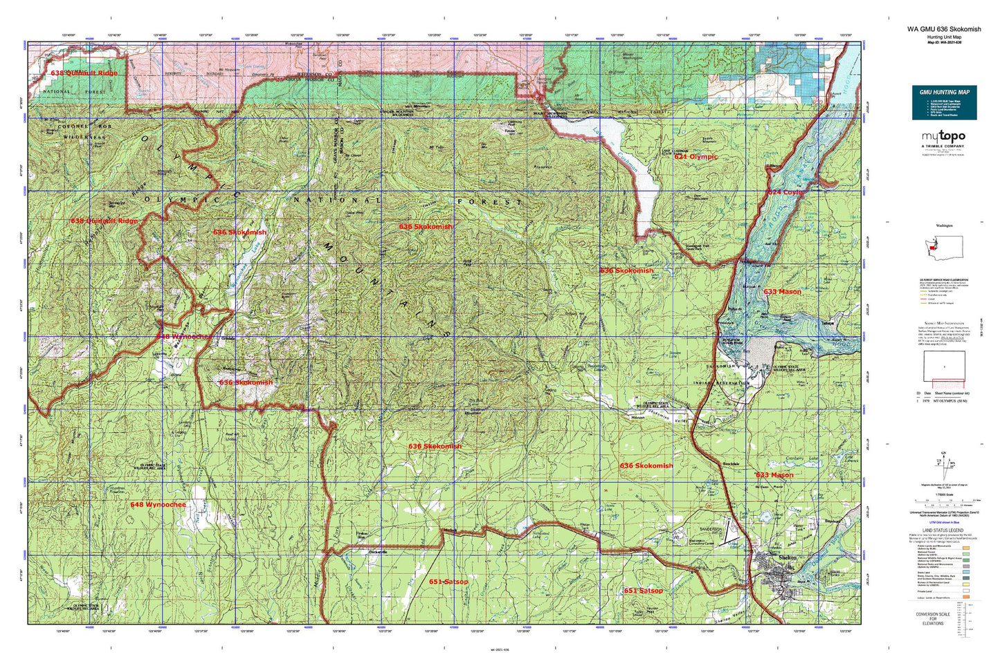
Washington GMU 636 Skokomish Map
Couldn't load pickup availability
Hunting unit map of Washington Game Management Unit 636 with topographic lines and unit boundaries. This topo map features UTM / MGRS and Latitude/Longitude grids, plus public land ownership. It comes folded on waterproof paper. Be fully prepared for your hunt with a MyTopo GMU map!.
This map contains the following named places: 98548,98560,Aberdeen Reservoir,Aberdeen Watershed,Anderson Butte,Anderson Butte Lookout,Anderson Creek,Aristine Creek,Armstrong Lake,Baker Creek,Baker Shelter,Beaver Flat,Big Creek,Big Creek Campground,Bingham Creek Reload,Bingham Creek Trail,Boundary Lakes,Brown Creek,Brown Creek Campground,Burlap Pass,Cabin Creek,Camp 3,Camp Comfort Shelter,Camp Govey,Camp Harps Shelter,Camp Roland,Campbell Shelter,Campbell Tree Grove Campground,Campell Shelter,Canyon River,Canyon River Shelter,Capitol Peak,Catfish Lake,Cedar Creek,Chapel Peak,Church Creek,Church Creek Shelter,Church of Christ,Clark Creek,Coho Campground,Colonel Bob Lookout,Colonel Bob Wilderness,Copper Creek,Cushman Dam,Cushman Hill,Dalby Creek,Danny Walker Creek,Dayton,Deckerville,Deer Meadow,Deer Meadow Creek,Dennie Ahl Hill,Dennie Ahl Hill Lookout,Dennie Ahl Seed Orchard,Dow Creek,Dow Mountain,Dow Mountain Lookout,Drake Lookout,Dry Bed Lakes,Dry Creek,Dry Mountain,Dusk Point,East Fork Big Creek,East Fork Shelter,Eleanor Creek,Falls Creek,Fir Creek,Fir Creek Guard Station,Fir Creek Reload,Fir Creek Work Center,Fitzgerald Peak,Flat Creek,Flatbottom Creek,Frigid Creek,Frisken Wye,George Adams Salmon Hatchery,Gibbons Creek,Gibson Creek,Gibson Peak,Go-Forth Creek,Grisdale,Grisdale Hill,Grisdale Hill Lookout,Grisdale Pond,Hanks Lake,Harp Creek,Harris Creek,Haven Lake,High Steel Bridge,Hillman Fish Pond,Hoodsport Trail State Park,Humptulips Ridge,Hunter Creek,Intermount Guard Station,Jackpot Lake,Jackpot Siding,Kent Lake,Kirkland Creek,Klone Lakes,Lake Cushman,Lake Cushman State Park,Lake Cushman State Park Campground,Lake Kokanee,Lake May,Lake Standstill,Lake West,Larsen Creek,Le Bar Creek,Le Bar Guard Station,Lightning Peak,Lilliwaup Swamp,Little Egypt Valley,Little Hanks Lake,Little River,Lower Cushman Dam,Malinowski Dam,Mason County,Mason County Fire District 16 Station 16 - 1,Mason County Fire District 18,Mason County Fire District 9,Matlock,Matlock Post Office,McTaggert Creek,Middle Fork Big Creek,Miller Pond,Mohrweis,Moonlight Dome,Morrow Lake,Mount Church,Mount Tebo,Musgrove Creek,Nahwatzel Lake,Neby Shelter,Neil Creek,Nicklund Creek,Nordby Lake,North Fork Skokomish River,North Fork West Branch Wynoochee River,Olympic National Forest,Oxbow,Parker Creek,Pederson Creek,Petes Creek,Pine Creek,Pine Lake,Price Lake,Prospect Ridge,Purdy Canyon,Quinault Ridge,Rabbit Creek,Reed Hill,Robertson Creek,Rock Creek,Rock Peak,Rose Lake,Rule Creek,Saddle Mountain,Satsop Lakes,Satsop Work Center,Save Creek,Scatter Creek,Schafer,Schafer Creek,Schofield Creek,Shelton Trout Hatchery,Simpson Lookout,Sixteen Creek,Skokomish Community Church,Skokomish Reservation,Skokomish Valley School,South Fork Skokomish River,South Mountain,Spider Lake,Spider Lake Shelter,Spoon Creek,Steel Creek,Stevens Lake,Stovepipe Mountain,Three Peaks,Timber Mountain,Trout Creek,Uddenberg Dam,Vance Creek,Vee Creek,Vincent Creek,Walter Creek,Washington Corrections Center,Washington Corrections Center Wastewater Treatment Plant,Washington State Patrol Academy,Weatherwax,Weatherwax Basin,Weatherwax Ridge,Weaver Creek,West Branch Wynoochee River,West Fork Big Creek,West Fork Shelter,West Lake Dam,West Mason Division,Windy Siding,Winter Creek,Wishkah Quarry,Wishkah Reservoir Number Three,Wishkah Reservoir Number Three Dam,Wishkah Reservoir Number Two,Wishkah Reservoir Number Two Dam,Woelfel Lake,Wynoochee Dam,Wynoochee Dam Visitor Center,Wynoochee Falls Campground,Wynoochee Fish Barrier,Wynoochee Lake,Wynoochee Shelter