MyTopo
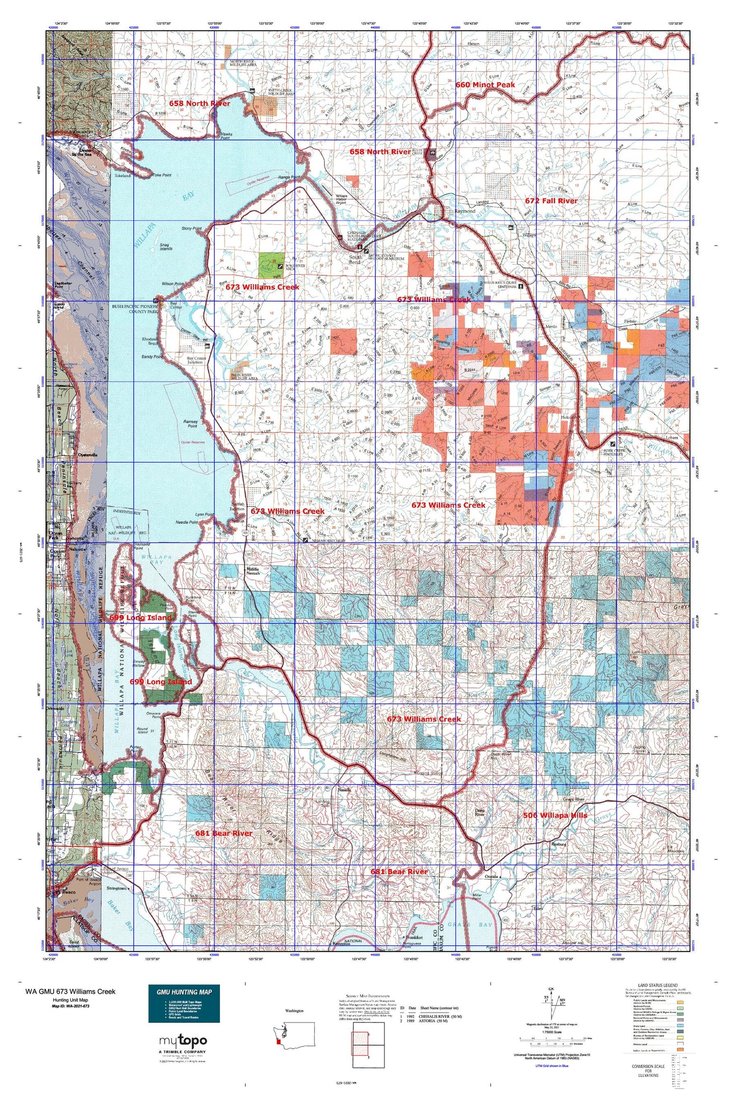
Washington GMU 673 Williams Creek Map
Couldn't load pickup availability
Hunting unit map of Washington Game Management Unit 673 with topographic lines and unit boundaries. This topo map features UTM / MGRS and Latitude/Longitude grids, plus public land ownership. It comes folded on waterproof paper. Be fully prepared for your hunt with a MyTopo GMU map!.
This map contains the following named places: 98527,98577,98586,98638,Alder Creek,Baldwin Slough,Bay Center,Bay Center Channel,Bay Center Cutoff Channel,Bay Center Junction,Bayshore Recreational Vehicle Park,Bear Branch,Bear Creek,Bear River,Beaver Creek,Bone River,Brock Creek,Bruceport,Bruceport Park,Burnham Creek,Bush Pioneer County Park,Butte Creek,Butte Creek Picnic Area,Butte Creek Reservoir,Camp One,Campbell Creek,Canon River,Canyon Creek,Case Pond,Cedar Creek,Cedar River,Cement Creek,Chetlo Harbor,City of Raymond,City of South Bend,Clearwater Creek,Cowan Peak Lookout,Davis Creek,Deep River,Deep River Hill,Dell Creek,Diamond Point,Donaldson Creek,Eagle Creek,East Raymond,Elk Creek,Elkhorn Creek,Ellen Sands,Ellsworth Creek,Ellsworth Slough,Fairchild Creek,Fall Creek,Finn Creek,Fork Creek,Forks Creek Hatchery,Fredrickson Slough,Freshwater Creek,Gamage Creek,Goose Point,Grays River,Green Creek,Halaya Slough,Hansen Creek,Hawks Point,Heldt Creek,Hendrickson Creek,High Point,Highland Creek,Holcomb,Holm Creek,Holm Ranch,Holton Ranch,Honey Creek,Howe Creek,Hull Creek,I I Slough,Johnson Creek,Johnson Ranch,Johnson Slough,Johnsons Landing,Kaffee Slough,Kellogg Slough,Kessel Creek,Kindred Island,King Creek,Kyle Ranch,Lagergren Ranch,Lane Creek,Lassila Creek,Lewis Slough,Little East Fork Naselle River,Long Island,Long Island Shoal,Long Island Slough,Longfellow Hill,Louse Rocks,Lynn Point,Mailboat Slough,Malone Creek,Menlo,Middle Fork Palix River,Middle Fork Rue Creek,Middle Nemah,Middle Nemah River,Mill Creek,Mill Ranch,Milne Quarry,Minks Ranch,Minnie Creek,Nallpee,Naselle,Naselle Division,Naselle Quarry,Naselle River,Naselle State Salmon Hatchery,Naselle Substation,Needle Point,Nemah,Nemah Hatchery,Nemah Junction,Nemah River Channel,Nemah Spit,Niawiakum River,Nikka Creek,Norris Slough,North Fork Fairchild Creek,North Fork Palix River,North Fork Williams Creek,North Fork Wilson Creek,North Naselle River,North Nemah,North Nemah River,North River,O'Conner Creek,Old Mill Pond,Oman Ranch,O'Meara Point,Owens Ponds,Oxbow Creek,Pacific County,Palix River,Palix State Wildlife Recreation Area,Paradise Point,Parpala Ranch,Person Creek,Petes Creek,Pickernell Creek,Pine Island,Pine Island Channel,Porter Point,Potter Slough,Ramsey Point,Range Point,Rangila Hill,Rangila Slough,Raymond,Raymond Division,Raymond Heights Reservoir,Raymond Sewage Treatment Plant Lagoon,Reef Ranch,Rhodesia Beach,Riddle Spit,Ring Ranch,Rosburg,Rose Ranch,Round Island,Rue Creek,Russell Channel,Russian Creek,S Ring Ranch,Salme Creek,Salme Hill,Salmon Creek,Sandy Point,Schlick Creek,Seahaven,Seal Creek,Seal Slough,Seaport,Shoalwater Bay,Silver Creek,Silvola Ranch,Skidmore Slough,Smith Creek,Smith Creek State Wildlife Recreation Area,Smoky Hollow,Snag Islands,South Bend,South Bend City Reservoir,South Bend Sewage Treatment Plant,South Burnham Creek,South Fork Palix River,South Fork Willapa River,South Naselle River,South Nemah River,Stanley Channel,Stanley Peninsula,Stanley Point,Stony Point,Stringer Creek,Stuart Slough,Sunshine,Sunshine Point,Teal Duck Slough,Teal Slough,Templin Quarry,Thadbar Creek,The Narrows,Timberland Village Mobile Home Park,Toke Point,Tokeland,Tokeland Marina,Trap Creek,Trap Creek Lookout,Upper Naselle Ranger Station,Upper Salmon Junction,Venice,Ward Creek,Welsh Ranch,West Fork Rue Creek,Whitcomb Creek,Willapa,Willapa Bay,Willapa Bayview Estates Mobile Home Park,Willapa Harbor Golf Course,Willapa Harbor Recreation Vehicle Park,Willapa National Wildlife Refuge,Willapa River,Williams Creek,Willie Keils Grave State Park,Wilme Slough,Wilson Creek,Wilson Point,Wirkkala Lake,Wirkkala Ponds