
MyTopo
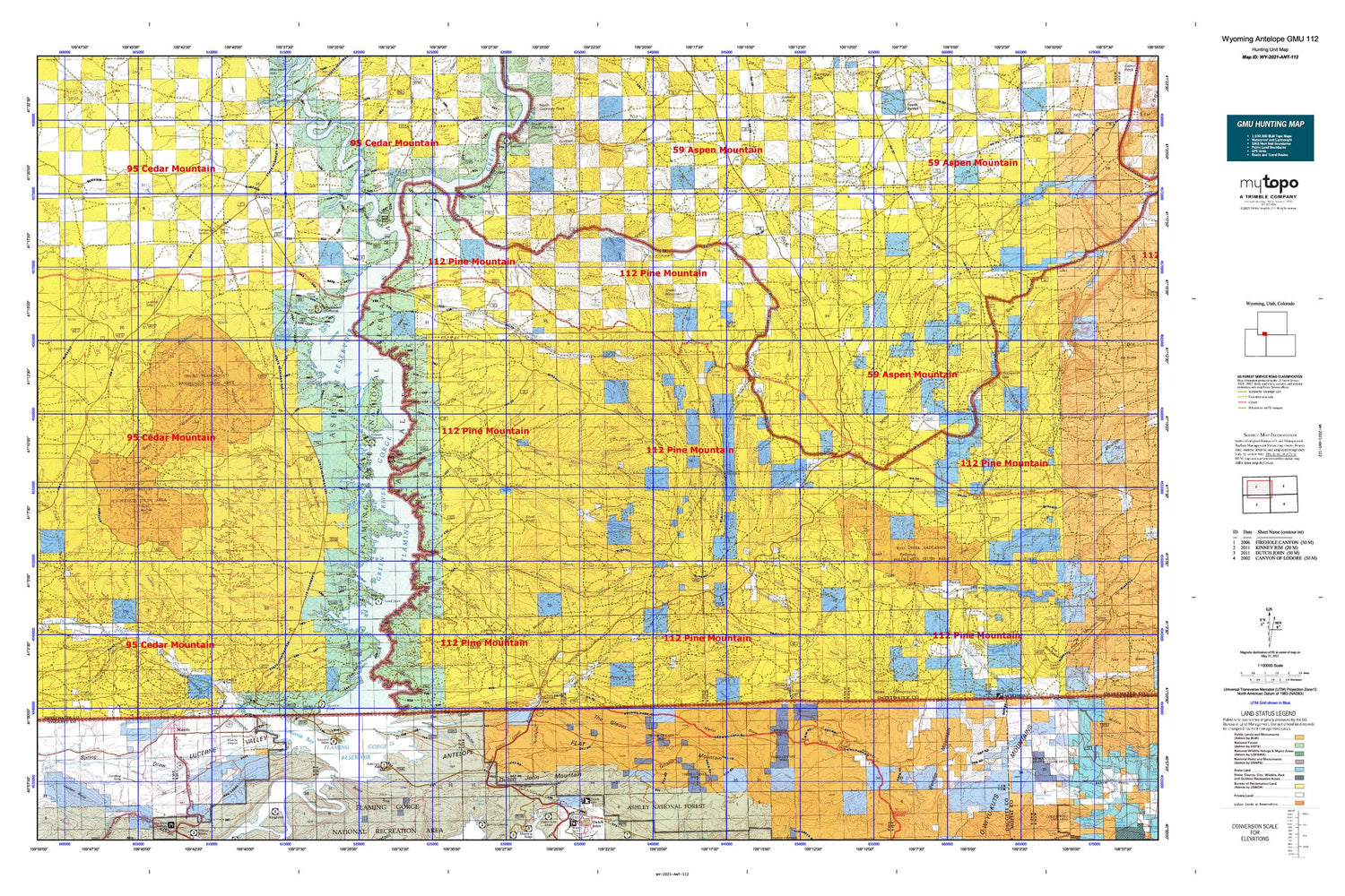
Wyoming Antelope GMU 112 Map
Couldn't load pickup availability
Hunting unit map of Wyoming Game Management Unit ANT-112 with topographic lines and unit boundaries. This topo map features UTM / MGRS and Latitude/Longitude grids, plus public land ownership. It comes folded on waterproof paper. Be fully prepared for your hunt with a MyTopo GMU map!.
This map contains the following named places: Alkali Springs,Angelovie Spring,Antelope Flat,Antelope Flat Campground,Antelope Flat Development,Antelope Hollow,Antelope Spring,Antelope Wash,Anvil Wash,Basin Creek,Bates Spring,Beans Spring,Beans Spring Creek,Beef Steer Creek,Beef Steer Spring,Bender Mountain,Big Bend,Big Pasture,Big Ridge,Big Spring,Birch Spring,Birch Spring Draw,Black Mountain,Black Spring Reservoir,Blacks Fork,Blaine Reservoir Number One,Blaine Reservoir Number Two,Briggs Dam,Brinegar Ferry,Brinegar Ranch,Brown Spring,Buckboard Crossing,Buckboard Reservoir,Buckboard Wash,Buckskin Basin,Buffalo Spring,Buster Basin,Camp Creek,Camp Creek Springs,Canyon Road Trail,Castello Creek,Castello Spring,Chicken Spring Pond,Chokecherry Draw,Chokecherry Spring,Clay Basin,Clay Basin Camp,Clay Basin Creek,Clay Basin Meadows,Clay Basin Wildlife Management Area,Coal Mine Draw,Cottonwood Creek,Coyote Spring,Crumb Canyon,Currant Creek,Currant Creek Ranch,Currant Creek Ridge,Daggett County Ambulance Service,Daggett County Jail,Daggett County Sheriff's Office,Daniels Creek,Davis Spring,Deer Spring,Devils Playground,Dipping Spring Canyon,Dodge Meadows,Dry Hollow,Dutch John Gap,Dutch John Mountain,East Fork Currant Creek,East Fork Trout Creek,East Grindstone Spring,Edith Aspden Park,Ely Creek,Ely Spring,Faulkner Draw,Fighting Spring,Finch Draw,Flaming Gorge,Flaming Gorge National Recreation Area,Flaming Gorge Reservoir,Flaming Gorge Valley,Flat Iron,Ford Draw,Ford Spring,Franklin Wash,Galloway Creek,Gap Spring,Gooseberry Creek,Goslin Mountain,Goslin Mountain Wildlife Management Area,Greasewood Draw,Greasewood Spring,Green River Mine,Green River South Division,Greenhough Creek,Greenhough Flats,Greenhough Place,Grindstone Spring,Grindstone Wash,Halfway Hollow,Hanks Meadow,Harris Spring,Hawks Nest,Haystack Buttes,Hazel Creek,Henrys Fork,Hogback,Holmes Crossing Recreation Site,Iron Mountain,Janes Meadow,Jarvies Marsh Creek,John Jarvie Mine,Johnson Draw,Jones Springs,June Creek,Kastler Compressor Station Airport,Krause Marsh Creek,Lane Meadow Creek,Linwood,Linwood Bay,Linwood Canyon,Little Basin Creek,Little Basin Ranch,Little Dry Creek,Little Mountain,Little Mountain Mine,Little Red Creek,Lizzie Spring Creek,Logan Place,Lousy George Spring,Lowe Canyon,Lucerne Point Group Site,Lucerne Valley,Lucerne Valley Campground,Lucerne Valley Development,Lucerne Valley Marina,Maggie Springs,Manila,Manila Airport,Manila Cemetery,Manila Elementary School,Manila High School,Manila Post Office,Manila Ranger Station,Manila Volunteer Fire Department,Martin Draw,Maxon Ranch,McCort Canyon,McKinnon Junction,Meadow Gulch,Meadow Gulch Ranch,Mellor Mountain,Menkeinney Mine,Middle Fork Currant Creek,Middle Marsh Creek,Minnies Gap,O-Wi-Yu-Kuts Draw,Parea Butte,Parea Spring,Peoples Canal,Pigeon Basin,Pigeon Canyon,Pine Spring,Poison Spring,Ramsay Desert,Ramsay Ranch,Ramsey Peak,Rawlins Draw,Red Creek Badlands,Red Creek Basin,Red Creek Ranch,Red Creek Ranch Airport,Red Jeep Number One Mine,Richards Gap,Richards Mountain,Richards Mountains,Richards Spring,Sage Creek,Sage Creek Basin,Sage Creek Mine,Sage Creek Ranch,Sally Draw,Sand Knoll,Scott Canyon,Sheep Creek Canal,Sheep Creek Irrigation Canal,Sheep Mountain,Silt Reservoir,Snow Creek,Soaphole Spring,South Spring,South Spring Draw,South Valley,Spitzi Creek,Spitzi Spring,Spring Creek,Squaw Hollow,Star Numbers Five and Six Mine,Sugarloaf Basin,Sugarloaf Marsh Creek,Sugarloaf Reservoir,Telephone Canyon,Tepee Creek,Tepee Mountains,The Church of Jesus Christ of Latter Day Saints,The Confluence,The Glades,The Narrows,Titsworth Gap,Titsworth Spring,Tommy James Basin,Town of Manila,Trough Draw,Trout Creek,Twin Buttes,Twin Buttes Draw,United States Forest Service Fire Station - Manila Office,Upper Marsh Creek,Upper Marsh Creek Boat Ramp,Upper Marsh Creek Recreation Site,Washam,Washam Census Designated Place,Washam Spring,Washam Wash,Webster Dugway,West Fork Currant Creek,West Fork Trout Creek,West Spring Creek,Wildhorse Basin,Wildhorse Draw,Willow Creek Butte,Winter Fat Reservoir,Worm Creek


