MyTopo
Wyoming Antelope GMU 113 Map
Couldn't load pickup availability
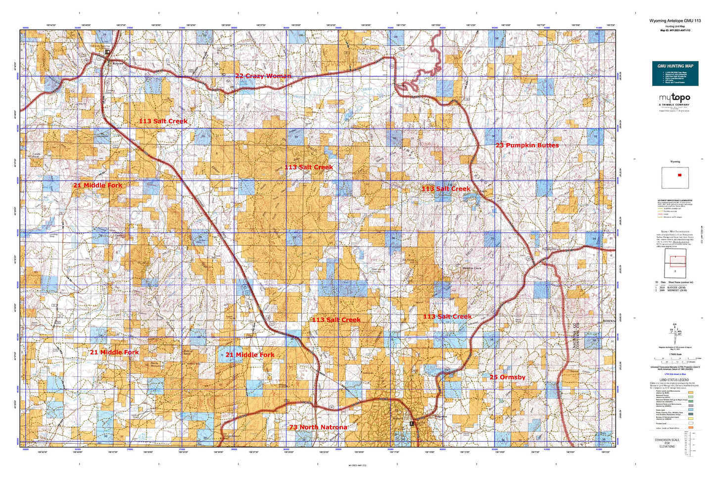
Hunting unit map of Wyoming Game Management Unit ANT-113 with topographic lines and unit boundaries. This topo map features UTM / MGRS and Latitude/Longitude grids, plus public land ownership. It comes folded on waterproof paper. Be fully prepared for your hunt with a MyTopo GMU map!.
This map contains the following named places: 82640,82643,Alkali Creek,Anderson Draw,Andrews Draw,Andrus Dam,Andrus Draw,Andrus Reservoir,Antelope Springs Ranch,Applegate Dam,Applegate Draw,Applegate Reservoir,Beach Draw,Bentonite Draw,Bentonite Draw Mine,Bobcat Basin,Bothwell Draw,Broken Horn Creek,Butts Ranch,Carpenter Draw,Chabot Ranch,Chalk Butte,Chocolate Reservoir,Coal Draw,Cole Draw,Comer Ranch,Crooked Creek,D Ranch,Davis Branch,Deadman Draw,Devils Monument,Dogtown Draw,Dugout Creek,Dugout Ranch,E Patterson Ranch,Eagle Canyon,East Fork Bullwhacker Creek,East Salt Creek Oil Field,East Spring Draw,East Tisdale Oil Field,Edgerton,Eldridge Draw,Ellis Dam,Ellis Reservoir,Ellison Draw,Endres Draw,Fay Dennis Draw,Fifteenmile Draw,Figure 8 Draw,Figure 8 Reservoir,Fisher Dam,Fisher Ranch,Fisher Reservoir,Flynn Draw,Frenchman Draw,Frenchy Basin,Frewens Castle,Frewens Draw,Gibbs Ranch,Gierse Draw,Government Creek,Grass Creek,Haines Ranch,Harper Reservoir,Hawk Draw,Hay Draw,Hot Water Creek,Hull Draw,Hull Ranch,Hunter Draw,Indart Ranch,Indian Draw,Indian Flats,Irvine Cow Camp,Jack Rabbit Numbers One and Two Claims,Jackrabbit Draw,Jarrard Ranch,Jarrard Rock Pile Mine,Jenks Draw,Joe Begant Draw,John Nolen Ditch,Jones Draw,Kaycee Bentonite Corporation Mine Number Fifty-six,Kaycee Bentonite Corporation Number Eighteen Mine,Kaycee Bentonite Corporation Number Eleven Mine,Kaycee Bentonite Corporation Number Fifteen Mine,Kaycee Bentonite Corporation Number Fifty Mine,Kaycee Bentonite Corporation Number Fifty-eight Mine,Kaycee Bentonite Corporation Number Fifty-four Mine,Kaycee Bentonite Corporation Number Fifty-one Mine,Kaycee Bentonite Corporation Number Fifty-three Mine,Kaycee Bentonite Corporation Number Forty-nine Mine,Kaycee Bentonite Corporation Number Fourteen Mine,Kaycee Bentonite Corporation Number Seventeen Mine,Kaycee Bentonite Corporation Number Seventy-one Mine,Kaycee Bentonite Corporation Number Seventy-two Mine,Kaycee Bentonite Corporation Number Sixteen Mine,Kaycee Bentonite Corporation Number Sixty Mine,Kaycee Bentonite Corporation Number Sixty-one Mine,Kaycee Bentonite Corporation Number Sixty-seven Mine,Kaycee Bentonite Corporation Number Sixty-two Mine,Kaycee Bentonite Corporation Number Ten Mine,Kaycee Bentonite Corporation Number Three Mine,Kaycee Bentonite Corporation Number Twelve Mine,Kaycee Bentonite Corporation Number Twenty-five Mine,Kaycee Bentonite Corporation Number Twenty-four Mine,Kaycee Bentonite Corporation Number Twenty-one Mine,Kaycee Bentonite Corporation Number Twenty-six Mine,Kaycee Bentonite Corporation Number Twenty-three Mine,Kaycee Bentonite Corporation Number Twenty-two Mine,Kaycee Bentonite Corporporation Number Fifty-five Mine,Keith Draw,Keith Reservoir,King Reservoir,Lane Creek,Leon Draw,Linch,Linstead Place,Lone Bear Creek,Lone Tree Draw,Lone Tree Gulch,Long Canyon,Losey Ranch,Lower Salt Creek Dam,Lower Salt Creek Reservoir,Lucky Draw,Lund Ranch,Martirena Ranch,Matthews Ranch,Mayor Ranch,Meadow Creek,Meadow Creek Oil Field,Metcalf Gulch,Microwave Pit,Middle Fork Powder River,Midwest,Million Creek,Missy Number One Mine,Monument Draw,Moonshine Draw,Muddy Draw,Murphy Creek,Murphy Gulch Ditch,N Jack Rabbit Dam,N Jack Rabbit Reservoir,Neff Reservoir,Newland Ditch,North Branch Crooked Creek,North Dam,North Fork Lone Tree Gulch,North Fork Powder River,North Meadow Creek Camp,North Meadow Creek Oil Field,North Reservoir,North Sandy Draw,North Sherwood Draw,North Spring Draw,North Sulphur Draw,North Terry Draw,North Tisdale Oil Field,Northeast Fork Toddy Draw,O'Conner Ranch,Oil Canyon,Old Kos Ranch,Ormsby Draw,Patrick Dam,Patrick Reservoir,Pavey Draw,Peterson Dam,Peterson Draw,Peterson Reservoir,Pickard Draw,Pine Grove Gulch,Pioneer Monument,Pollard Draw,Posey Creek,Pugsley Draw,Pugsley Mine,Quinn Dam,Quinn Reservoir,Raitt Draw,Robertson Dam,Robertson Reservoir,Rock Ridge,Salt Creek,Schiffer Mine,Scott Creek,Scott Dam,Scott Reservoir,Shannon Pool Oil Field,Sherwood Creek,Six Horse Hill,Snyder Ranch,South Fork Powder River,South Fork Powder River Mine,South Wall Dam,South Wall Number 3 Dam,South Wall Reservoir,Spratt Reservoir,Steele Formation Mine,Streeter Ranch,Sussex,Sussex Irrigation Canal,Sussex Oil Field,Sussex Repressuring Plant,Sussex Unit,Taylor Ranch,The Chimney,The Wall,Thomas Creek,Three Forks Reservoir,Tillman Ranch,Tisdale Ditch,Tisdale Mountain,Tisdale Number Four Mine,Tisdale Number Nine Mine,Tisdale Number One Mine,Tisdale Number Seven Mine,Tisdale Number Six Mine,Tisdale Number Ten Mine,Tisdale Number Three Mine,Tisdale Number Two Mine,Town of Edgerton,Town of Midwest,TTT Ranch,Turk Ranch,Turkey Springs Creek,Ullery Mine,Vest Ranch,Wall Creek,Well Riley Ranch,West Fork Bullwhacker Creek,West Sussex-Dugout Oil Field,Willow Creek,Willow Reservoir