
MyTopo
Wyoming Antelope GMU 19 Map
Couldn't load pickup availability
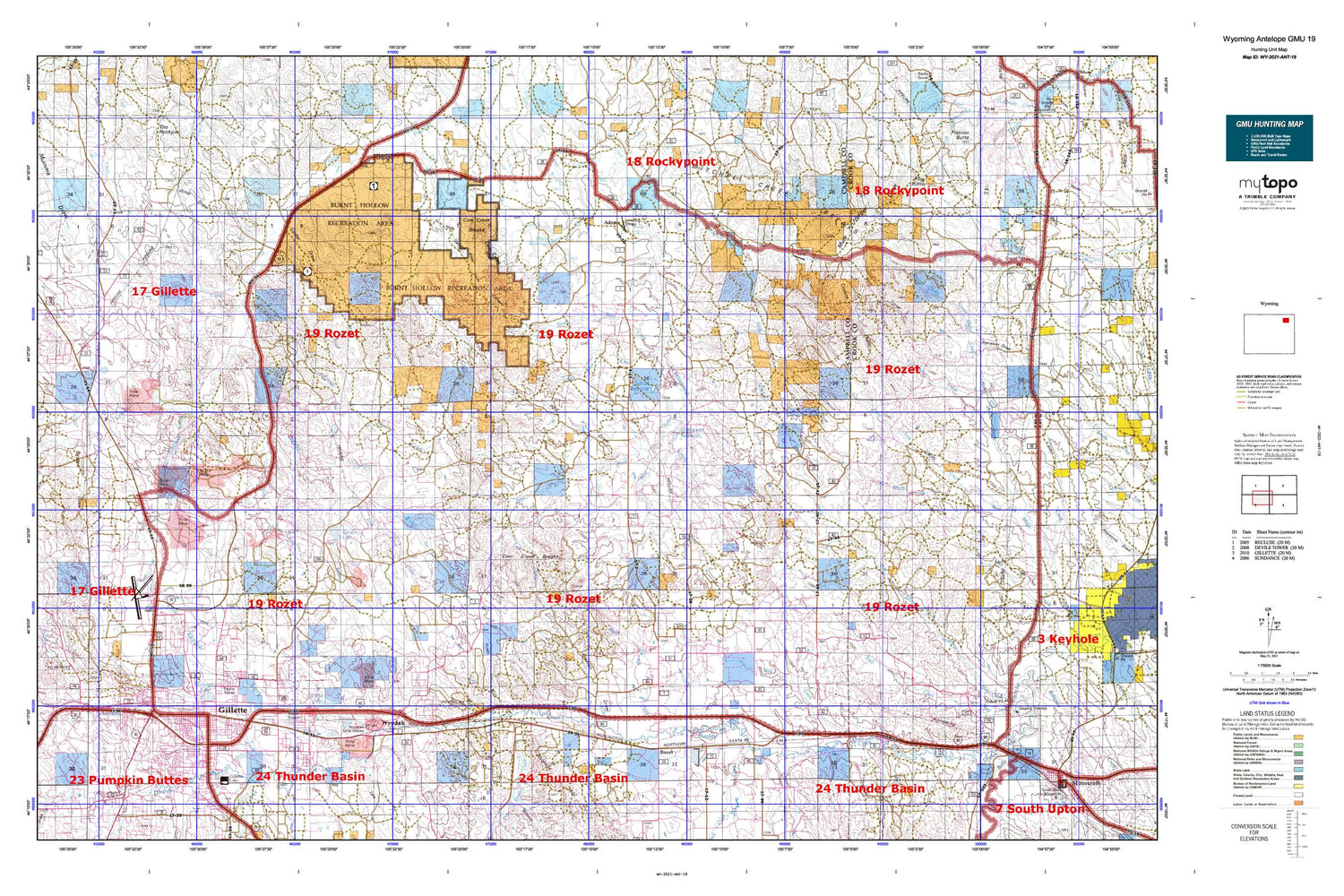
Hunting unit map of Wyoming Game Management Unit ANT-19 with topographic lines and unit boundaries. This topo map features UTM / MGRS and Latitude/Longitude grids, plus public land ownership. It comes folded on waterproof paper. Be fully prepared for your hunt with a MyTopo GMU map!.
This map contains the following named places: 82727,Adon,Allee Reservoir,Barker Mine,Barney Number 2 Dam,Barney Number 2 Reservoir,Box Elder Draw,Buck Creek,Buckskin Mine,Bull Creek,Burkhardt Pit,Burlington Lake,C White Number 1 Dam,Camel Plaza Shopping Center,Campbell County Emergency Medical Services,Campbell County Fire Department Station 1,Campbell County Fire Department Station 12,Campbell County Fire Department Station 13,Campbell County Fire Department Station 2,Campbell County Fire Department Station 7,Campbell County Fire Department Training Center,Campbell County Memorial Hospital,Campbell County Sheriff's Office,Cedar Draw,Cherry Reservoir,City of Gillette,Cliff White Reservoir,Clovis Point Mine,Clyde Potter Quarry,Coal Mine Draw,Collins Heights,Cook Dam,Cook Reservoir,Corner Reservoir,Corral Creek,Cow Creek Breaks,Cow Creek Ranch,Cow Creek Wall,Cox Dam,Cox Reservoir,Coyote Draw,Cradle Butte,Dalbey Memorial Park,Davis Dam,Davis Reservoir,Deer Creek,Deer Creek Breaks,Ditto Lake,Ditto Mine,Dry Creek,Dry Donkey Creek,Dry Fork Little Powder River,Dutch Reservoir,East Prong Deer Creek,Elmore Mine,Fischer Draw,Fischer Reservoir,Flag Butte,Fortin Draw,Franey Rock,Garner Lake,Gilbert Draw,Gillete Fishing Lake Dam,Gillette,Gillette - Campbell County Airport Fire Department,Gillette Country Club,Gillette Dam,Gillette Fishing Lake,Gillette Police Department,Gillette Post Office,Gillette-Campbell County Airport,Grant Spring,Green Hill,Grover Draw,Grover Reservoir,Halsted Spring,Hamm Draw,Hay Creek,Hells Canyon Draw,Hillcrest Elementary School,Hines Pit,Holiday Plaza Shopping Center,Hornet Pit,Indian Tree Hill,Jackson Dam,Jackson Reservoir,Jiggs Dam,Jiggs Draw,Jiggs Reservoir,June Draw,KAML-FM (Gillette),Keils Mine,Keuhne Dam,Keuhne Reservoir,KIML-AM (Gillette),Koch Dam,Koch Reservoir,Kummerfeld Oil Field,Lee Draw,Little Mitchell Creek,Little Mitchell Creek Breaks,Little Pasture Creek,Little Rawhide Creek,Lone Cedar Spring,Madsen Airport,Miller Creek Oil Field,Minturn,Mitchell Creek,Mitchell Creek Breaks,M-O Oil Field,Mount Pisgah Cemetery,Moyer Mine,Moyer Springs,Mule Herder Draw,Nagle Spring,Nelson Dam,Nelson Reservoir,North Donkey Creek Oil Field,North Draw,North Fork Hay Creek,North Rawhide Mine,North Side School,North Twin Creek,North Twin Well,Oiler Draw,Oiler Reservoir,Peerless Mine,Pioneer Manor Nursing and Convalescent Home,Pleasant Valley Cemetery,Pleasant Valley Oil Field,Post Draw,Powder Basin Center,Prairie Creek,Preston Draw,Provant Creek,Raudsep Number 1 Dam,Raudsep Number 1 Reservoir,Raw Hide Dam,Rawhide Butte,Rawhide Creek,Rawhide Dam,Rawhide Mine,Rawhide Mine Main Dam,Rawhide Mine Main Reservoir,Rawhide Reservoir,Rawhide School,Road Creek,Road Draw,Rochelle Hills,Rough Draw,Rozet,Rozet Cemetery,Rozet Oil Field,Rozet Post Office,Rozet School,Russell Draw,Sawmill Creek,School Reservoir,Selmek Oil Field,Shepherd Pit,Six Half Circle Spring,South Fork West Fork Miller Creek,South Twin Creek,Spring Draw,Springen Ranch Oil Field,Stewart Ranch Oil Field,Stonepile Creek,Tanner Number 1 Dam,Tanner Number 1 Reservoir,Tharp Reservoir,Thompson Creek,Thompson Draw,Vines Mine,Wagonhammer Butte,Wagonhammer Ranch,Ward Creek,Well Creek,Well Draw,West Fork Cottonwood Creek,Wheat Draw,White Number 2 Dam,Wildwood Christian Retreat,Windmill Creek,Windmill Draw,Wolf Draw,Wreath Hill,Wyodak,Wyodak Ash Pond Dam,Wyodak Ash Pond Reservoir,Wyodak Strip Mine,Wyoming Highway Patrol District 4 Division L,Zoe Draw


