
MyTopo
Wyoming Antelope GMU 56 Map
Couldn't load pickup availability
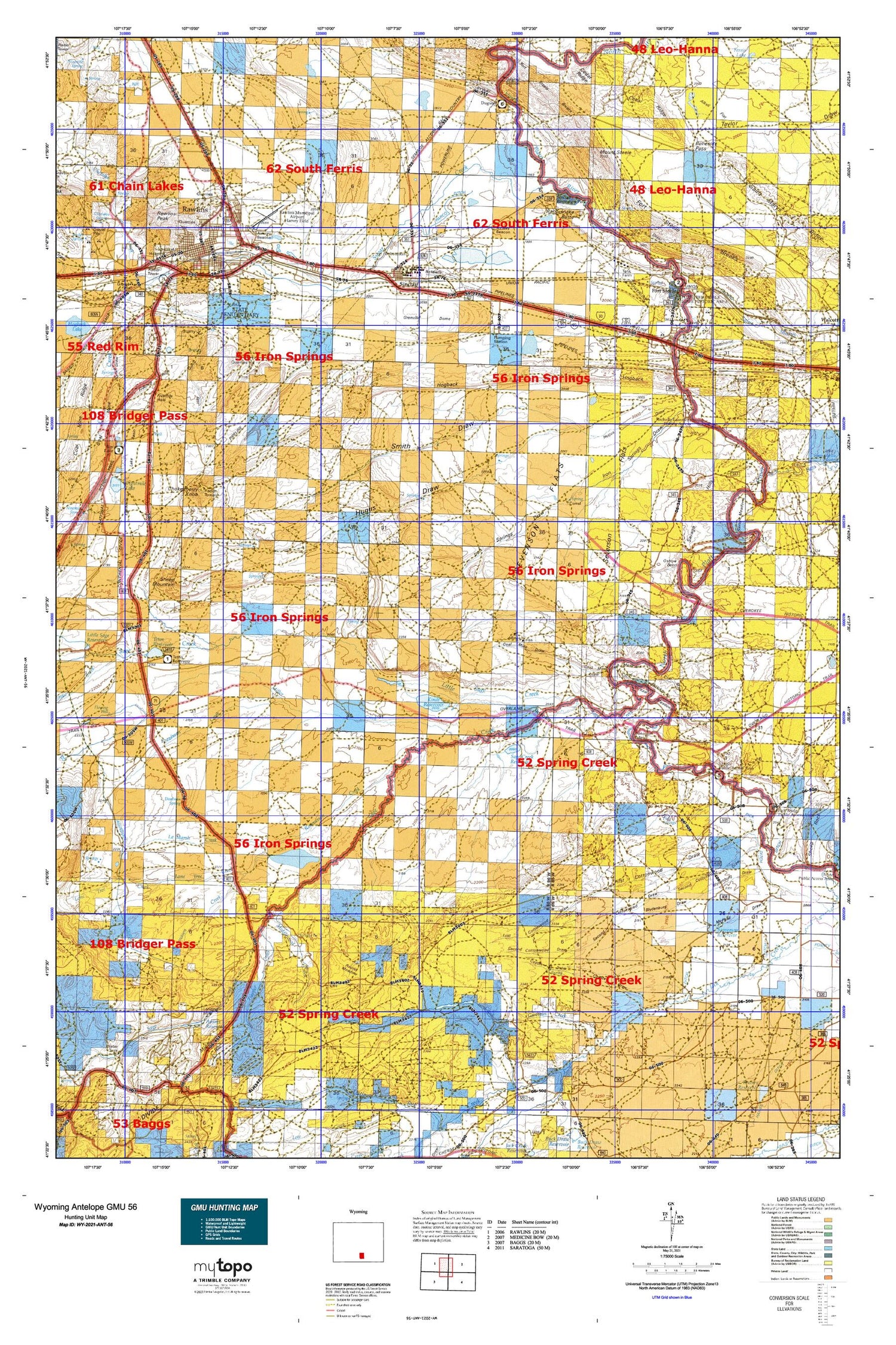
Hunting unit map of Wyoming Game Management Unit ANT-56 with topographic lines and unit boundaries. This topo map features UTM / MGRS and Latitude/Longitude grids, plus public land ownership. It comes folded on waterproof paper. Be fully prepared for your hunt with a MyTopo GMU map!.
This map contains the following named places: Adams Dam,Adams Reservoir,Alkali Flat,Blydenburg and Morgan North Ditch,Blydenburg and Morgan South Ditch,Blydenburg Draw,Bolten Ranch,Boneside Pass,Carbon County,Carbon County Emergency Medical Services Rawlins,Carbon County Fire Department Rawlins,Carbon County Museum Cemetery,Carbon County Sheriff's Office Rawlins,Cedar Ridge,Charlie Claim Group Mine,Cherokee Creek,Chokecherry Knob,Christensen Ranch,City of Rawlins,Coal Banks,Coal Creek,Coal Mine Draw,Corpening Ranch,Coyote Draw,Coyote Spring,Deadman Creek,Deadman Springs,Donald Mcphail Ditch,Dry Draw,Duncan Ranch,Eightmile Lake Basin,Enberg Ranch,Everist Mine,First Cottonwood Draw,Fivemile Hole,Fivemile Ridge,Fort Fred Steele,Fort Steele,Fort Steele Breaks,Fort Steele Historic Site Cemetery,Good Number 1 Dam,Good Number 1 Reservoir,Grenville Dome,Hatfield Oil Field,Hay Gulch,Highlands Estate Shopping Center,Hogback,Hugus Draw,Iron Springs Draw,Johnson Island,Johnston Number 2 Dam,Johnston Number 2 Reservoir,Kent Meadows,KFNR-TV (Rawlins),KIQZ-FM (Rawlins),KRAL-AM (Rawlins),La Marsh Creek,Larsen Mine,Little Sage Creek,Lone Tree Creek,Long Pond Dam,Long Pond Reservoir,Marion Ditch,Martinez Max Sand and Gravel Pit,McKeal Meadows,McKeal Mine,Meadow Ranch,Memorial Hospital Heliport,Memorial Hospital of Carbon County,Middlewood Creek,Middlewood Hill,Middlewood Ranch,Midget Geyser,Miller Creek,Moomaw Everist Mine,Mount Steele,Mountainview School,Old Frazier Place,Old Haymaker Place,Old Johnson Place,Old McKeal Place,Overland Crossing Cemetery,Oxbow Bend,Parco Ditch,Pass Creek,Peck Mine,Pershing School,Petty Mine,Phillips Mine,Pick Ranch,Pine Grove Ranch,Rasmussen Creek,Rattlesnake Butte,Rawlins,Rawlins Cemetery,Rawlins Fire Department Station 1,Rawlins Fire Department Station 2,Rawlins Fire Department Training Center,Rawlins Municipal Airport/Harvey Field,Rawlins Peak,Rawlins Peaking Dam,Rawlins Peaking Reservoir,Rawlins Police Department,Rawlins Post Office,Ream and Ramsey Mine,Rodeo Park,Round Meadow,Sage Basin Mine,Sage Creek,Sage Creek Dam,Sage Creek Reservoir,Sage Creek Stage Station,Saint Joseph School,Saint Marys Creek,Saint Marys Ridge,Savage Hills,Savage Meadows,Savage Ranch,Seahorn Mine,Seaverson Dam,Seaverson Reservoir,Selfour Ranch,Severson Flats,Sheep Mountain,Sheep Mountain Reservoir,Shultz Ranch,Sinclair,Sinclair Police Department,Sinclair Post Office,Sinclair Recreation Park,Sinclair Refinery Volunteer Fire Department,Sinclair School,Sinclair Volunteer Fire Department,Sinclair Volunteer Fire Department Station 2,Smith Draw,Sugar Creek,Sunnyside School,Taylor Draw,Teton Reservoir,Teton Reservoir Dam,The Old Bob Place,Town of Sinclair,Trapper Creek,Walck Ranch,Wet Draw,Whitehorse Canyon,Wild Horse Canyon,Wyoming Highway Patrol District 1 Division H,Wyoming State Penitentiary,Wyoming State Penitentiary Cemetery


