MyTopo
Wyoming Antelope GMU 59 Map
Couldn't load pickup availability
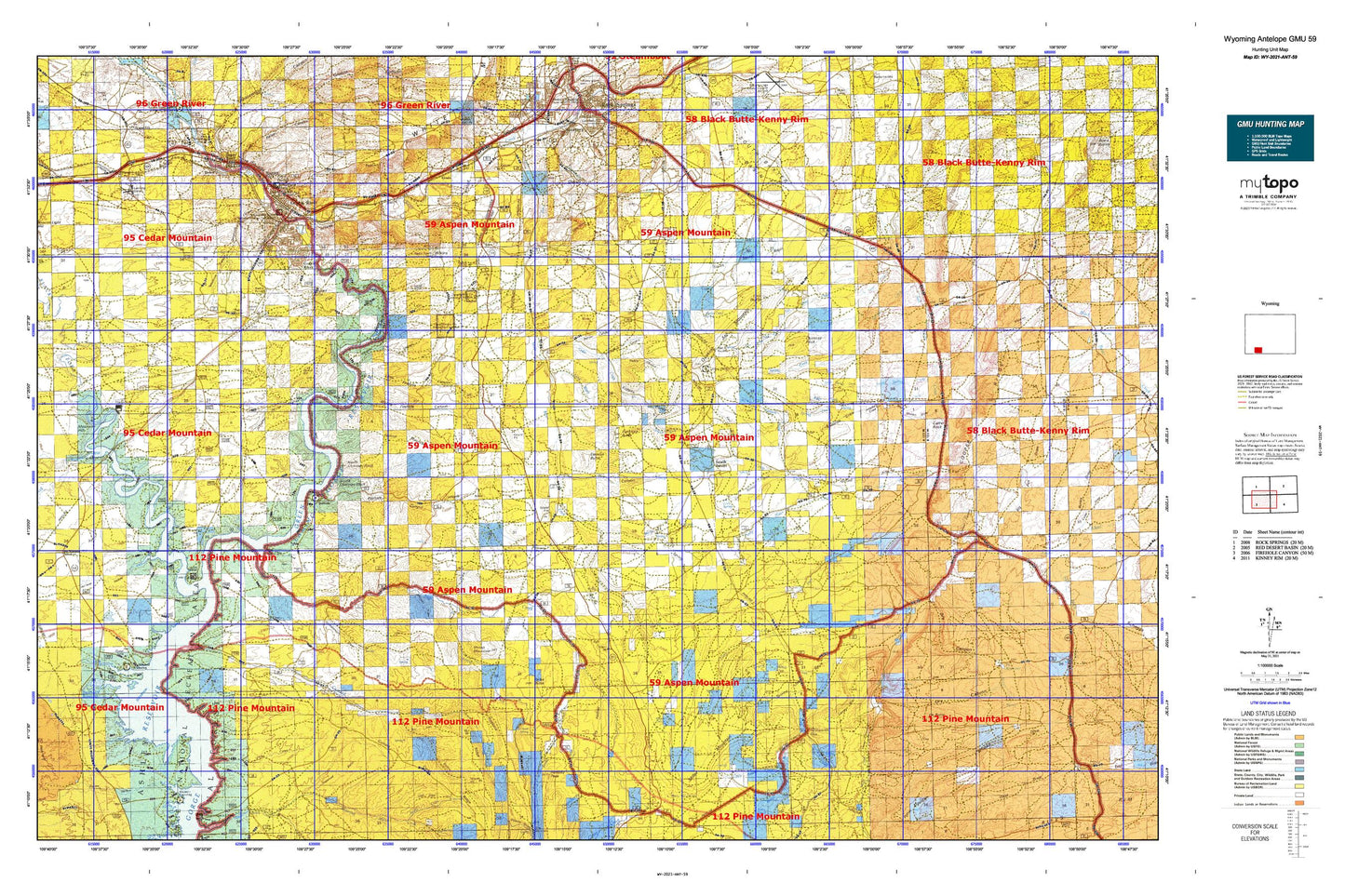
Hunting unit map of Wyoming Game Management Unit ANT-59 with topographic lines and unit boundaries. This topo map features UTM / MGRS and Latitude/Longitude grids, plus public land ownership. It comes folded on waterproof paper. Be fully prepared for your hunt with a MyTopo GMU map!.
This map contains the following named places: 82901,Acme Pit,Antelope Butte,Antelope Draw,Arrowhead Springs,Arrowhead Springs Census Designated Place,Aspen Mountain Mine,Barney Canyon,Beans Spring Creek,Big Bend,Big Dry Creek,Big Flat Draw,Big Pasture,Big Ridge,Bitter Creek,Blacks Fork,Blacks Fork Bridge,Blaine Reservoir Number One,Blaine Reservoir Number Two,Blair Creek,Boat Bottom,Briggs Dam,Buckboard Crossing,Buckboard Reservoir,Buckboard Wash,Burnt Canyon,Burnt Canyon Creek,Camel Rock,Castle Rock,Castle Rock Ambulance Services,Castle Rock Convalescent Center,Cedar Creek,Chicken Springs Draw,Chimney Rock,Circle,Circle Creek,Circle Springs,Circle Springs Draw,City of Green River,Coal Mine Canyon,Cooper Ridge,Cordwood Bottom,Coyote Canyon,Coyote Spring,Currant Creek,Currant Creek Ranch,Cutthroat Draw,Dans Creek,Davis Bottom,Diamond Alkali Company Number Three Mine,Diamond Alkali Company-Butler Well Number One Mine,Dolly Meadow,Dorrence Recreation Park,Dry Canyon,Dry Canyon Spring,Dry Hollow,Dugway Canyon,Eagle Rock,Earnest Butte,East Draw,East Salt Wells Creek,Elk Butte,Erickson Canyon,Faulkner Draw,Firehole Basin,Firehole Canyon,Firehole Canyon Campground,Fish Cut,Flaming Gorge National Recreation Area,Flaming Gorge Shopping Center,Flattop Mountain,Gap Creek,Gap Spring,Giants Thumb,Gooseberry Creek,Granger Volunteer Fire Department,Greasewood Canyon,Greasewood Draw,Greasewood Spring,Greater Green River Intergalactic Spaceport,Green River,Green River Area Mine,Green River Fire Department,Green River Police Department,Green River Post Office,Halfway Hollow,Hogback,Hutton Heights Shopping Center,Iron Spring,Island Park,James Town,Janes Meadow,Jim Washum Spring,Johnson Draw,Joyce Creek,Kanda,Kappes Canyon,Kent Mine Number One,KGWR-TV (Rock Springs),KQSW-FM (Rock Springs),KSIT-FM (Rock Springs),KUGR-AM (Green River),KYCS-FM (Rock Springs),Laney Canyon,Laney Rim,Laney Spring,Laney Wash,Lincoln High School,Lion Bluffs,Little Basin Creek,Little Basin Ranch,Little Dry Creek,Little Firehole Canyon,Little Mellor Canyon,Logan Draw,Logan Place,Lowe Canyon,Maggie Springs,Massacre Hill,McCort Canyon,McKinnon Junction,Mellor Mountain,Menkeinney Mine,Middle Firehole Canyon,Miller Ranch,Mud Mine,Mud Springs Ranch,Mullen Camp Spring,Ninemile Spring,No Name Creek,North Chimney Rock,Old Stage Station,Parea Butte,Pedro Claims,Peru,Pine Creek,Pio Moses Ranch,Pio Reservoir,Pio Spring,Potter Mountain Reservoir,Pretty Water Creek,Purple Sage,Purple Sage Census Designated Place,Quaking Asp Mountain,Quealy,Rainbow Mine,Ramsay Desert,Ramsay Ranch,Ramsey Peak,Reiser Canyon,Riovista,Riverview Cemetery,Riview,Rock Canyon,Rock Springs Coal Company Number One Mine,Rock Springs South Division,Roosevelt School,Sage Creek,Sage Creek Basin,Sage Creek Mine,Sage Creek Ranch,Sally Draw,Sand Wash,Scott Bottom,Sheep Mountain,Slippery Jim Canyon,Snow Spring Creek,South Baxter,South Baxter Basin,South Chimney Rock,South Fork Cedar Creek,South Spring,South Spring Draw,Spring Creek,Squaw Hollow,Station Draw,Sugar Bowl Rock,Sugarloaf Basin,Sulphur Creek,Sweeney Ranch,Sweeney Ranch Census Designated Place,Sweetwater County Sheriff's Office,Table,Teakettle Rock,Telephone Canyon,The Confluence,The Palisades,The Towers,Three Patches Picnic Area,Titsworth Gap,Titsworth Spring,Tollgate Rock,Tommy James Basin,Tommy James Creek,Trout Creek,Walkie Canyon,Washington School,Webster Dugway,Whalen Bottom,Whalen Butte,Whiskey Bend,Wilkins Peak,Worm Creek