MyTopo
Wyoming Antelope GMU 64 Map
Couldn't load pickup availability
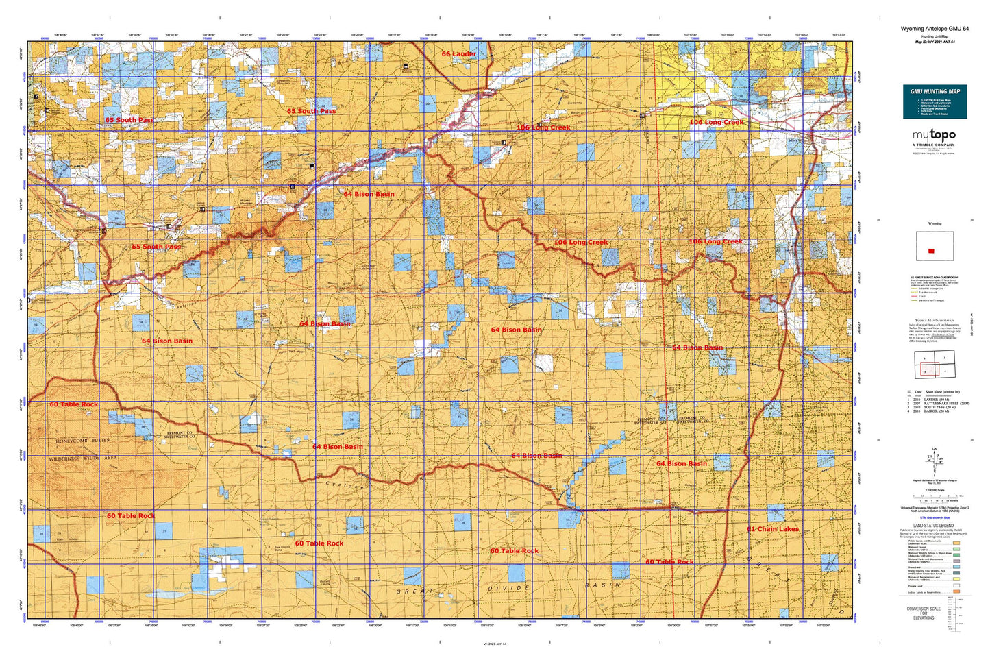
Hunting unit map of Wyoming Game Management Unit ANT-64 with topographic lines and unit boundaries. This topo map features UTM / MGRS and Latitude/Longitude grids, plus public land ownership. It comes folded on waterproof paper. Be fully prepared for your hunt with a MyTopo GMU map!.
This map contains the following named places: Alkali Creek,Amanda Mine,Antelope Hills,Antelope Reservoir,Arapahoe Creek,Arapahoe Ditch,Arnold Ditch Number 1,Arnold Spring,Baby Antelope Reservoir,Barras Springs,Beaver Dam Ditch,Big Bend,Big Nugget Claim,Bison Basin Oil Field,Bison Basin Project Mine,Brannan Number 1 Dam,Brannan Number 1 Reservoir,Brannan Reservoir,Brown Ditch,Buck Spring,Buffalo Basin,Buffalo Bill Camp,Buffalo Gulch,Bull Canyon,Bullion Mine,Burr Gulch,Burr Mine,Canoys Cabin,Carpenter Ranch,Chapman Homestead,Chicken Springs,Chimney Creek,Circle Bar Lake,Cold Spring Reservoir,Copper Chief Gold Mine,Cottonwood Creek,Cow Camp Spring,Coyote Gulch,Coyote Lake,Crows Nest,Crows Nest Gulch,Cyclone Draw,Cyclone Rim,Daley Lake,Deep Creek,Diamond Springs,Duncan Draw,East Alkali Creek,East Arapahoe Creek,Eight Lazy Y Ranch,Ellis Ranch,Eye of the Eagle,Five Fingers Butte,Flattop Buttes,Fort Stambaugh Historical,French George Crossing,Giblin Gulch,Gilespie Place,Gold Dollar Mine,Graham and Farmsley Ditch Number 1,Graham and Farmsley Ditch Number 2,Graham Ranch Pit,Granite Creek,Granite Spring,Grassy Lake,Hadsell Cabin,Hadsell Reservoir,Happy Spring,Happy Spring Creek,Happy Spring Sheep Camp,Happy Springs Oil Field,Harris Ditch,Harris Slough,Hay Gulch,Haypress Creek,Hidden Hand Mine,Honeycomb Buttes,Horace Gulch,Horse Track Ridge,Horse Track Spring,Hyde Homestead,Immigrant Springs,Irish Gulch,Iron Duke Mine,Jabcig Mine,Jamerman Ranch,Jones Gulch,Kinch McKinney Spring,Kindt Ranch,Ladysmith Creek,Ladysmith Draw,Ladysmith Spring,Lame Jack Gulch,Last Chance Number Three Mine,Level Meadows Creek,Lewiston,Lewiston Area Mine,Lewiston Lakes,Little Beaver Creek,Little Osborne Lake,Long Gulch,Long Slough,Lost Creek Reservoir,Lower Ladysmith Spring,Lower Mormon Spring,Magpie Creek,Maxwell Claim,McKay Lake,McKay Reservoirs,McLean Meadows,McTurk Spring,Metterling Prospect,Middle Fork Sulphur Creek,Miller Ditch,Mitten Springs,Mormon Creek,Mud Spring,Murray Lake,North Bear Mountain,North Fork Bear Creek,North Fork Sulphur Creek,Obert Homestead,Olson Spring,Olson Springs,Omara Gulch,Osborne Draw,Osborne Reservoir,Osborne Spring,P B Creek,P B Spring,Picket Creek,Picket Lake,Radium Springs,Rate Homestead,Red Hill Mine,Rock Creek,Rock Creek Ditch,Rock Creek Hollow Cemetery,Saint Marys Peak,Saint Marys Spring,Saint Marys Station,Sand Creek,Scotty Lake,Silver Creek,Silver Creek Dam,Silver Creek Reservoir,Smiley Springs,Smith Gulch,Soap Holes,South Fork Silver Creek,South Fork Sulphur Creek,Spring Creek,Stinking Springs Draw,Stinking Springs Reservoir,Stough Lake,Stratton Lakes,Strawberry Creek,Sulphur Bar Spring,Sulphur Creek,Sweeney Basin,Tierney Spring,Upper Mormon Spring,Wagon Tire Spring,Warm Springs,Warm Springs Creek,Weasel Draw,Weasel Spring,West Alkali Creek,West Arapahoe Creek,Willow Creek,Wilson Gulch,Woods Gulch Pond,Woolery Ranch Spring,Yellowstone Cow Camp